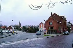
Rumst
Rumst (Dutch pronunciation: [rʏmst], old spelling: Rumpst) is a municipality located in the Belgian province of Antwerp. Since 1976 the municipality not only comprises Rumst proper but also the towns of Reet (old spelling: Reeth) and Terhagen, which were independent municipalities before that year.
Rumst | |
|---|---|
 | |
 Flag  Coat of arms | |
Location of Rumst | |
 Rumst Location in Belgium
Location of Rumst in the province of Antwerp 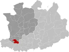 | |
| Coordinates: 51°05′N 04°25′E | |
| Country | |
| Community | Flemish Community |
| Region | Flemish Region |
| Province | Antwerp |
| Arrondissement | Antwerp |
| Government | |
| • Mayor | Jurgen Callaerts (N-VA) |
| • Governing party/ies | N-VA, CD&V -3D |
| Area | |
| • Total | 20.15 km2 (7.78 sq mi) |
| Population (2018-01-01)[1] | |
| • Total | 15,114 |
| • Density | 750/km2 (1,900/sq mi) |
| Postal codes | 2840 |
| NIS code | 11037 |
| Area codes | 03, 015 |
| Website | www.rumst.be |
Industry in Rumst, like Boom, was heavily focused around the production of clay products like bricks. This industry has largely disappeared after 1970.
In Rumst, the river Rupel starts as a combination of the Dijle and Nete (river) rivers.
In 2021, Rumst had a total population of 15,146. The total area is 19.90 km² (7.7 sq mi).[2]
Notable residents
- Kristof Calvo, Belgian politician, was born in Rumst
- Yvonne Verbeeck, actress
References
- "Wettelijke Bevolking per gemeente op 1 januari 2018". Statbel. Retrieved 9 March 2019.
- "Bevolking per statistische sector - Sector 11037". Statistics Belgium. Retrieved 10 May 2022.
External links
 Media related to Rumst at Wikimedia Commons
- (in Dutch) Official website
Places adjacent to Rumst | |
|---|---|

This article is issued from Wikipedia. The text is licensed under Creative Commons - Attribution - Sharealike. Additional terms may apply for the media files.