Runoff (hydrology)
Runoff is the flow of water across the earth, and is a major component in the hydrological cycle. Runoff that flows over land before reaching a watercourse is referred to as surface runoff or overland flow. Once in a watercourse, runoff is referred to as streamflow, channel runoff, or river runoff. Urban runoff is surface runoff created by urbanization.
Background

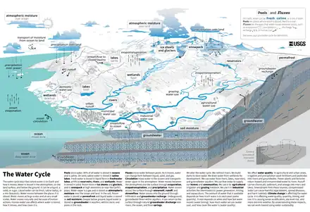
The water cycle, also known as the hydrologic cycle or the hydrological cycle, is a biogeochemical cycle that describes the continuous movement of water on, above and below the surface of the Earth. The mass of water on Earth remains fairly constant over time but the partitioning of the water into the major reservoirs of ice, fresh water, saline water (salt water) and atmospheric water is variable depending on a wide range of climatic variables. The water moves from one reservoir to another, such as from river to ocean, or from the ocean to the atmosphere, by the physical processes of evaporation, transpiration, condensation, precipitation, infiltration, surface runoff, and subsurface flow. In doing so, the water goes through different forms: liquid, solid (ice) and vapor. The ocean plays a key role in the water cycle as it is the source of 86% of global evaporation.[1]
The water cycle involves the exchange of energy, which leads to temperature changes. When water evaporates, it takes up energy from its surroundings and cools the environment. When it condenses, it releases energy and warms the environment. These heat exchanges influence climate.
The evaporative phase of the cycle purifies water, causing salts and other solids picked up during the cycle to be left behind, and then the condensation phase in the atmosphere replenishes the land with freshwater. The flow of liquid water and ice transports minerals across the globe. It is also involved in reshaping the geological features of the Earth, through processes including erosion and sedimentation. The water cycle is also essential for the maintenance of most life and ecosystems on the planet.Surface runoff
Surface runoff (also known as overland flow or terrestrial runoff) is the unconfined flow of water over the ground surface, in contrast to channel runoff (or stream flow). It occurs when excess rainwater, stormwater, meltwater, or other sources, can no longer sufficiently rapidly infiltrate in the soil. This can occur when the soil is saturated by water to its full capacity, and the rain arrives more quickly than the soil can absorb it. Surface runoff often occurs because impervious areas (such as roofs and pavement) do not allow water to soak into the ground. Furthermore, runoff can occur either through natural or human-made processes.[2]
Surface runoff is a major component of the water cycle. It is the primary agent of soil erosion by water.[3][4] The land area producing runoff that drains to a common point is called a drainage basin.
Runoff that occurs on the ground surface before reaching a channel can be a nonpoint source of pollution, as it can carry human-made contaminants or natural forms of pollution (such as rotting leaves). Human-made contaminants in runoff include petroleum, pesticides, fertilizers and others.[5] Much agricultural pollution is exacerbated by surface runoff, leading to a number of down stream impacts, including nutrient pollution that causes eutrophication.
In addition to causing water erosion and pollution, surface runoff in urban areas is a primary cause of urban flooding, which can result in property damage, damp and mold in basements, and street flooding.Urban runoff

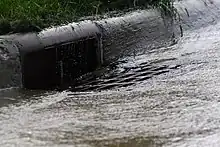
Urban runoff is surface runoff of rainwater, landscape irrigation, and car washing[6] created by urbanization. Impervious surfaces (roads, parking lots and sidewalks) are constructed during land development. During rain, storms, and other precipitation events, these surfaces (built from materials such as asphalt and concrete), along with rooftops, carry polluted stormwater to storm drains, instead of allowing the water to percolate through soil.[7] This causes lowering of the water table (because groundwater recharge is lessened) and flooding since the amount of water that remains on the surface is greater.[8][9] Most municipal storm sewer systems discharge untreated stormwater to streams, rivers, and bays. This excess water can also make its way into people's properties through basement backups and seepage through building wall and floors.
Urban runoff can be a major source of urban flooding and water pollution in urban communities worldwide.Channel runoff
Model
A runoff models or rainfall-runoff model describes how rainfall is converted into runoff in a drainage basin (catchment area or watershed). More precisely, it produces a surface runoff hydrograph in response to a rainfall event, represented by and input as a hyetograph. Rainfall-runoff models need to be calibrated before they can be used.
A well known runoff model is the linear reservoir, but in practice it has limited applicability.
The runoff model with a non-linear reservoir is more universally applicable, but still it holds only for catchments whose surface area is limited by the condition that the rainfall can be considered more or less uniformly distributed over the area. The maximum size of the watershed then depends on the rainfall characteristics of the region. When the study area is too large, it can be divided into sub-catchments and the various runoff hydrographs may be combined using flood routing techniques.Curve number
References
- "Water Cycle | Science Mission Directorate". science.nasa.gov. Archived from the original on 2018-01-15. Retrieved 2018-01-15.
- "runoff". National Geographic Society. 2011-01-21. Retrieved 2021-02-19.
- Ronnie Wilson, The Horton Papers (1933)
- Keith Beven, Robert E. Horton's perceptual model of infiltration processes, Hydrological Processes, Wiley Intersciences DOI 10:1002 hyp 5740 (2004)
- L. Davis Mackenzie and Susan J. Masten, Principles of Environmental Engineering and Science ISBN 0-07-235053-9
- "Impact of Water Runoff from Streets and Yards". Highlands Ranch, CO: Highlands Ranch Metro District. Retrieved 30 August 2021.
- "Runoff (surface water runoff)". USGS Water Science School. Reston, VA: U.S. Geological Survey (USGS). 2018-06-06.
- Water Environment Federation, Alexandria, VA; and American Society of Civil Engineers, Reston, VA. "Urban Runoff Quality Management." WEF Manual of Practice No. 23; ASCE Manual and Report on Engineering Practice No. 87. 1998. ISBN 1-57278-039-8. Chapter 1.
- Schueler, Thomas R. (2000) [initial publ. 1995]. "The Importance of Imperviousness". In Schueler; Holland, Heather K. (eds.). The Practice of Watershed Protection. Ellicott City, MD: Center for Watershed Protection. pp. 1–12. Archived from the original (pdf) on 2014-03-27. Retrieved 2014-12-24.
- United States Department of Agriculture (1986). Urban hydrology for small watersheds (PDF). Technical Release 55 (TR-55) (Second ed.). Natural Resources Conservation Service, Conservation Engineering Division.