Țaga
Țaga (Hungarian: Cege; German: Zegen) is a commune in Cluj County, Transylvania, Romania. It is composed of five villages: Năsal (Noszoly), Sântejude (Vasasszentegyed), Sântejude-Vale (Vasasszentegyedi völgy), Sântioana (Vasasszentiván), and Țaga.
Țaga | |
|---|---|
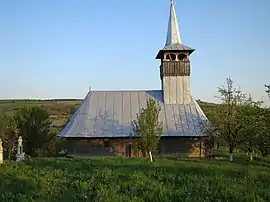 Wooden church (1804) in Năsal | |
 Location in Cluj County | |
 Țaga Location in Romania | |
| Coordinates: 46°56′44.52″N 24°3′33.84″E | |
| Country | Romania |
| County | Cluj |
| Subdivisions | Năsal, Sântioana, Sântejude, Sântejude-Vale, Țaga |
| Government | |
| • Mayor (2020–2024) | Romulus Mârza[1] (PNL) |
| Area | 100.01 km2 (38.61 sq mi) |
| Elevation | 313 m (1,027 ft) |
| Population (2011-10-31)[2] | 1,947 |
| • Density | 19/km2 (50/sq mi) |
| Time zone | EET/EEST (UTC+2/+3) |
| Postal code | 407565 |
| Vehicle reg. | CJ |
| Website | www |
Geography
The commune is located in the eastern part of the county, having as neighbors: to the east Bistrița-Năsăud County and Chiochiș commune, to the south Geaca and Pălatca communes, to the west Sic commune, and to the north Fizeșu Gherlii and Sânmartin communes. Țaga is crossed by the county road DJ 109C Cămărașu–Gherla, a road that connects the national roads Apahida-Reghin and the national road Cluj-Napoca–Gherla–Dej.
Demographics
According to the census from 2002 there was a total population of 2,162 people living in this commune. Of this population, 91.67% are ethnic Romanians, 6.15% are ethnic Hungarians, and 2.12% ethnic Romani.[3]
Natives
See also
- Wass Castle
References
- "Results of the 2020 local elections". Central Electoral Bureau. Retrieved 11 June 2021.
- "Populaţia stabilă pe judeţe, municipii, oraşe şi localităti componenete la RPL_2011" (XLS). National Institute of Statistics.
- "Structura Etno-demografică a României".
- Atlasul localităților județului Cluj (Cluj County Localities Atlas), Suncart Publishing House, Cluj-Napoca, ISBN 973-86430-0-7
 Church (Țaga)
 Traditional house (Țaga)
 Wass Castle (Țaga)
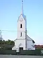 Reformed church, 15th century (Năsal)
.JPG.webp) Reformed church (Sântejude)
Reformed church (Sântejude)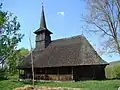 Wooden church (Sântejude)