Florida State Road 501
State Road 501 (SR 501) is a three-mile (5 km) long north–south highway entirely within Cocoa, Florida, in the United States. It southern terminus is an intersection with King Street (SR 520); its northern terminus is an intersection with SR 524 just south of an interchange with State Road 528 and Grissom Parkway. The road is also known as Clearlake Road. Until the mid-1980s, it was State Road 503A.
State Road 501 | ||||
|---|---|---|---|---|
| Clearlake Road | ||||
| Route information | ||||
| Maintained by FDOT | ||||
| Length | 3.358 mi[1] (5.404 km) | |||
| Major junctions | ||||
| South end | ||||
| North end | ||||
| Location | ||||
| Country | United States | |||
| State | Florida | |||
| Highway system | ||||
| ||||

SR 501 is a commercial artery of Cocoa, with shopping centers on both sides of the street. A campus of Brevard Community College is also located on Clearlake Road.
Major intersections
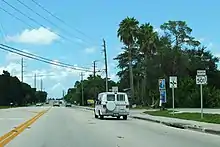
Northbound on SR 501 in Cocoa
The entire route is in Brevard County.
| Location | mi[1] | km | Destinations | Notes | |
|---|---|---|---|---|---|
| | 0.000 | 0.000 | |||
| Cocoa | 1.193 | 1.920 | Dixon Boulevard (CR 503 east) | ||
| 3.358 | 5.404 | ||||
| 1.000 mi = 1.609 km; 1.000 km = 0.621 mi | |||||
References
- FDOT Straight Line Diagram of Road Inventory for State Road 501 (PDF File), accessed 30 November 2017
External links
Template:Attached KML/Florida State Road 501
KML is not from Wikidata
 Media related to Florida State Road 501 at Wikimedia Commons
This article is issued from Wikipedia. The text is licensed under Creative Commons - Attribution - Sharealike. Additional terms may apply for the media files.