Mandi district
Mandi district is one of the central districts of Himachal Pradesh state in northern India. The town of Mandi is the headquarters of the district.
Mandi district | |
|---|---|
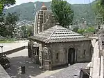     Clockwise from top-left: Triloknath temple, Mandi, IIT Mandi, view of Nargu Wildlife Sanctuary, Prashar Lake, Rewalsar Lake | |
.svg.png.webp) Location in Himachal Pradesh | |
| Country | |
| State | |
| Headquarters | Mandi, India |
| Area | |
| • Total | 3,951 km2 (1,525 sq mi) |
| Population (2011) | |
| • Total | 999,777 |
| • Density | 250/km2 (660/sq mi) |
| Time zone | UTC+05:30 (IST) |
| Major highways | NH 3, NH 154 |
| Website | http://hpmandi.nic.in/ |
The main native language is Mandeali.[1]
As of 2011, it is the second most populous district of Himachal Pradesh (out of 12), after Kangra.[2]
Demographics
| Year | Pop. | ±% p.a. |
|---|---|---|
| 1901 | 228,721 | — |
| 1911 | 236,038 | +0.32% |
| 1921 | 239,376 | +0.14% |
| 1931 | 265,873 | +1.06% |
| 1941 | 303,685 | +1.34% |
| 1951 | 310,626 | +0.23% |
| 1961 | 384,259 | +2.15% |
| 1971 | 515,180 | +2.98% |
| 1981 | 644,827 | +2.27% |
| 1991 | 776,372 | +1.87% |
| 2001 | 901,344 | +1.50% |
| 2011 | 999,777 | +1.04% |
| source:[3] | ||
According to the 2011 census, Mandi district has a population of 9,99,777[2] roughly equal to the nation of Fiji[4] or the US state of Montana.[5] This gives it a ranking of 446th in India (out of a total of 640).[2] The district has a population density of 253 inhabitants per square kilometre (660/sq mi).[2]
Its population growth rate over the decade 2001-2011 was 10.89%.[2] Mandi has a sex ratio of 1012 females for every 1000 males[2] and a literacy rate of 82.81%. 6.27% of the population lives in urban areas. Scheduled Castes and Scheduled Tribes make up 29.38% and 1.28% of the population respectively.[2]
At the 2011 census, 59.11% of the population in the district identified their first language as Mandeali, 33.32% opted for Pahari (a term broadly applicable to most Indo-Aryan languages of Himachal and Uttarakhand), while 4.1% chose Hindi, 0.66% – Punjabi and 0.47% – Kangri.[7]
Subdivisions
Mandi district Divived in to 12 Sub divisions:
- Mandi Sadar
- Balh
- Sundar Nagar
- Sarkaghat
- Dharampur
- Joginder Nagar
- Padhar
- Gohar
- Thunag
- Karsog
- Balichoki
- Kotli[8]
Villages in the district include Janjheli, which falls in Thunag Tehsil. It is near Kullu-Manali, around 80 km from Bhunter Airport, 90 km from Kullu and 67 km from Mandi. It has thick deodar forests, sprawling apple orchards, and springs. It is a trekking/hiking outpost. Shikari Devi is a tourist spot. It hosts Himachal Cultural Village, an ethnic village highlighting the culture of Himachal Pradesh.[9]
Politics
| No. | Constituency | Member | Party | Remarks | Reference | |
|---|---|---|---|---|---|---|
| 26 | Karsog (SC) | Hira Lal | Bhartiya Janata Party | |||
| 27 | Sundernagar | Rakesh Jamwal | Bhartiya Janata Party | |||
| 28 | Nachan (SC) | Vinod Kumar | Bharatiya Janata Party | |||
| 29 | Seraj | Jai Ram Thakur | Bharatiya Janata Party | Chief Minister | ||
| 30 | Darang | Jawahar Thakur | Bharatiya Janata Party | |||
| 31 | Jogindernagar | Prakash Rana | Bharatiya Janata Party | Defected From Independent To BJP[10] | ||
| 32 | Dharampur | Mahender Singh | Bharatiya Janata Party | Jal Shakti Minister | ||
| 33 | Mandi | Anil Sharma | Bharatiya Janata Party | MPP and Power Minister (27.12.2017–13.04.2019) | [11] | |
| 34 | Balh (SC) | Inder Singh | Bharatiya Janata Party | [12] | ||
| 35 | Sarkaghat | Inder Singh | Bharatiya Janata Party | Chairman, Subordinate Legislation Committee | [13] | |
Education
Universities and colleges

- Indian Institute of Technology Mandi (IIT Mandi)
- Jawaharlal Nehru Government Engineering College
- Sardar Vallabhbhai Patel Cluster University
- Shri Lal Bahadur Shastri Government Medical College & Hospital Mandi
- College of Horticulture and Centre of Excellence for Horticulture Research and Extension, Thunag
- Atal Bihari Vajpayee University of Medicine and Health Sciences (upcoming)
Polytechnics
- Govt Polytechnic Sundernagar
- Industrial Training Institute (ITI) Mandi
Sports
The district is home to the Bandy Federation of India[14] which is a member of the IOC recognized[15] Federation of International Bandy.
See also
References
- Lewis, M. Paul (2009). "Mandeali". Ethnologue: Languages of the World, Sixteenth edition. Dallas, TX: SIL International. Retrieved 3 October 2009.
- "District Census Handbook: Mandi" (PDF). censusindia.gov.in. Registrar General and Census Commissioner of India. 2011.
- "Decadal Variation In Population Since 1901".
- US Directorate of Intelligence. "Country Comparison:Population". Archived from the original on 13 June 2007. Retrieved 1 October 2011.
Fiji 883,125 July 2011 est.
- "2010 Resident Population Data". U. S. Census Bureau. Archived from the original on 19 October 2013. Retrieved 30 September 2011.
Montana 989,415
- "Table C-01 Population by Religion: Himachal Pradesh". censusindia.gov.in. Registrar General and Census Commissioner of India. 2011.
- "Table C-16 Population by Mother Tongue: Himachal Pradesh". www.censusindia.gov.in. Registrar General and Census Commissioner of India.
- "Sub-Division, Tehsil and Sub Tehsil | District Mandi, Government of Himachal Pradesh | India".
- "- KULLU MANALI HIMACHAL CULTURAL VILLAGE Ethnic Cultural Village in the Himalayas". Archived from the original on 22 August 2018. Retrieved 23 March 2020.
- "Two Independent MLAs join BJP in Himachal". Hindustan Times. 9 June 2022. Retrieved 26 August 2022.
- "Anil Sharma". Himachal Pradesh - 13th Legislative Assembly (Vidhan Sabha). Archived from the original on 27 October 2014. Retrieved 27 November 2021.
- "Inder Singh". Himachal Pradesh 13th Legislative Assembly ( Vidhan Sabha ). Archived from the original on 6 November 2021. Retrieved 3 December 2021.
- "Inder Singh". Himachal Pradesh 13th Legislative Assembly (Vidhan Sabha). Archived from the original on 6 November 2021. Retrieved 3 December 2021.
- "Federation of International Bandy-About-About FIB-National Federations-India". Archived from the original on 4 October 2009. Retrieved 2 November 2009.
- "Federation of International Bandy-Olympic". Archived from the original on 3 October 2009. Retrieved 2 September 2011.
External links
- Mandi district website
- DISTRICT PROFILE
- CULTURAL & TOURISM HERITAGE OF THE DISTT
- Janjehli Valley Himachal Pradesh
Places adjacent to Mandi district | |
|---|---|
