Saint-Lin–Laurentides
Saint-Lin–Laurentides is a small city located in the Montcalm Regional County Municipality of Quebec, Canada. Its official name uses an en dash; however, the city's own website uses the two-hyphen version of its name: Saint-Lin-Laurentides. In the Canada 2021 Census its population was 24,030.
Saint-Lin–Laurentides | |
|---|---|
| Ville de Saint-Lin–Laurentides | |
.jpg.webp) Route 335 | |
 Location within Montcalm RCM. | |
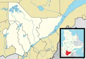 Saint-Lin–Laurentides Location in central Quebec. | |
| Coordinates: 45°51′N 73°46′W[1] | |
| Country | |
| Province | |
| Region | Lanaudière |
| RCM | Montcalm |
| Settled | 1807 |
| Constituted | March 1, 2000 |
| Government | |
| • Mayor | Mathieu Maisonneuve |
| • Federal riding | Montcalm |
| • Prov. riding | Rousseau |
| Area | |
| • Total | 118.80 km2 (45.87 sq mi) |
| • Land | 118.29 km2 (45.67 sq mi) |
| Population (2021)[3] | |
| • Total | 24,030 |
| • Density | 203.2/km2 (526/sq mi) |
| • Pop 2016-2021 | |
| • Dwellings | 9,615 |
| Time zone | UTC−5 (EST) |
| • Summer (DST) | UTC−4 (EDT) |
| Postal code(s) | |
| Area code(s) | 450 and 579 |
| Highways[4] | |
| Website | www |
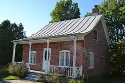
Saint-Lin was the birthplace of former Canadian Prime Minister Wilfrid Laurier, whose paternal home is now a National Historic Site of Canada.
History
Saint-Lin–Laurentides was formed on 1 March 2000, when the Municipality of Saint-Lin and the Town of Laurentides were merged.[5]
Saint-Lin was first settled in 1807 when pioneers from Saint-Pierre-du-Portage (now L'Assomption) arrived. In 1828, the Saint-Lin-de-Lachenaie Parish was founded. In 1845, the Parish Municipality of Saint-Lin was established, but was abolished 2 years later in 1847 when it was absorbed into the county municipality. That same year, its post office opened. In 1855, the municipality was reestablished as Saint-Lin-de-Lachenaye, with Carolus Laurier, father of Sir Wilfrid Laurier, as first mayor.[5]
Laurentides was originally the Village Municipality of Saint-Lin, which became an incorporate entity in 1856. In 1883, it changed name and statutes and became the Town of Laurentides. Also that year, the local post office opened.[6]
Demographics
In the 2021 Census of Population conducted by Statistics Canada, Saint-Lin—Laurentides had a population of 24,030 living in 9,289 of its 9,615 total private dwellings, a change of 15.6% from its 2016 population of 20,786. With a land area of 118.29 km2 (45.67 sq mi), it had a population density of 203.1/km2 (526.1/sq mi) in 2021.[7]
Population:[8]
- Population in 2021: 24,030 (2006 to 2011 population change: 15.6%)
- Population in 2016: 20,786 (2006 to 2011 population change: 19.0%)
- Population in 2011: 17,463 (2006 to 2011 population change: 23.3%)
- Population in 2006: 14,159 (2001 to 2006 population change: 14.4%)
- Population in 2001: 12,379
- Population in 1996:
- Laurentides: 2703
- Saint-Lin: 9336
- Population in 1991:
- Laurentides: 2336
- Saint-Lin: 7029
Mother tongue:
- English as first language: 1.5%
- French as first language: 94.2%
- English and French as first language: 1.1%
- Other as first language: 2.5%
Education
The Commission scolaire des Samares operates francophone public schools
- École de l'Aubier[9]
- École des Trois-Temps
- École du ruisseau
Sir Wilfrid Laurier School Board operates English-language public schools. Schools serving the town:
- Joliette Elementary School in Saint-Charles-Borromée serves most of the town[13]
- Laurentia Elementary School in Saint-Jérôme serves a portion of the town[14]
- Joliette High School in Joliette serves all of the town[15]
References
- "Reference number 360840 in Banque de noms de lieux du Québec". toponymie.gouv.qc.ca (in French). Commission de toponymie du Québec.
- "Geographic code 63048 in the official Répertoire des municipalités". www.mamh.gouv.qc.ca (in French). Ministère des Affaires municipales et de l'Habitation.
- Statistics Canada 2021 Census - Saint-Lin-Laurentides census profile
- Official Transport Quebec Road Map
- "Saint-Lin–Laurentides (Ville)" (in French). Commission de toponymie du Québec. Retrieved 2009-09-24.
- "Laurentides (Ville)" (in French). Commission de toponymie du Québec. Retrieved 2009-09-24.
- "Population and dwelling counts: Canada, provinces and territories, and census subdivisions (municipalities), Quebec". Statistics Canada. February 9, 2022. Retrieved August 29, 2022.
- Statistics Canada: 1996, 2001, 2006, 2011, 2016, 2021 census
- "de l'Aubier." Commission scolaire des Samares. Retrieved on September 23, 2017.
- "des Trois-Temps (pavillon de l'Arc-en-Ciel)." Commission scolaire des Samares. Retrieved on September 23, 2017.
- "des Trois-Temps (pavillon de l'Oiseau-Bleu)." Commission scolaire des Samares. Retrieved on September 23, 2017.
- "des Trois-Temps (pavillon Sir-Wilfrid-Laurier)." Commission scolaire des Samares. Retrieved on September 23, 2017.
- "JOLIETTE ELEMENTARY ZONE." Sir Wilfrid Laurier School Board. Retrieved on September 17, 2017.
- "LAURENTIA ELEMENTARY ZONE." Sir Wilfrid Laurier School Board. Retrieved on September 4, 2017.
- "Joliette High School Zone Sec 1-5." Sir Wilfrid Laurier School Board. Retrieved on September 5, 2017.
External links
 Media related to Saint-Lin–Laurentides at Wikimedia Commons
- (in French) Ville de Saint-Lin-Laurentides
Places adjacent to Saint-Lin–Laurentides | ||||||||||||||||
|---|---|---|---|---|---|---|---|---|---|---|---|---|---|---|---|---|
| ||||||||||||||||
| Cities/towns | |
|---|---|
| Municipalities | |
| |