Saint John County, New Brunswick
Saint John County (2016 population: 74,020[1]) is located in southern New Brunswick, Canada. The city of Saint John dominates the county. Elsewhere in the county, tourism is focused around the Bay of Fundy.

Saint John | |
|---|---|
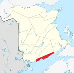 Location within New Brunswick. | |
| Coordinates: 45°18′N 66°00′W | |
| Country | Canada |
| Province | New Brunswick |
| Established | 1785 |
| Area | |
| • Land | 1,463.70 km2 (565.14 sq mi) |
| Population (2016)[1] | |
| • Total | 74,020 |
| • Density | 50.6/km2 (131/sq mi) |
| • Change 2011-2016 | |
| • Dwellings | 36,825 |
| Time zone | UTC-4 (AST) |
| • Summer (DST) | UTC-3 (ADT) |
| Area code | 506 |
Census subdivisions
Communities
There are two municipalities within Saint John County (listed by 2016 population):[2]
| Official Name | Designation | Area km2 | Population | Parish |
|---|---|---|---|---|
| Saint John | City | 315.96 | 67,575 | Simonds |
| Fundy-St. Martins | Village | 2.35 | 276 | Saint Martins |
Parishes
The county is subdivided by the Territorial Division Act (Section 27) into one city and three parishes (listed by 2016 population):[2]
| Official Name | Area km2 | Population | Municipalities | Unincorporated communities |
|---|---|---|---|---|
| Saint John (city) | 315.96 | 67,575 | Saint John (city) | |
| Simonds | 280.86 | 3,843 | Baxters Corner / Black River / Cape Spencer / Coleraine / Fairfield / Gardner Creek / Garnett Settlement / Grove Hill / Lake View Estates / Mispec / Otter Lake / Primrose / Quaco Road / Simonds / Upper Golden Grove / Upper Loch Lomond / West Beach / Willow Grove | |
| Musquash | 235.33 | 1,194 | Chance Harbour / Dam Road / Dipper Harbour East / Dipper Harbour West / Five Fathom Hole / Gilmore Subdivision / Gooseberry Cove / Little Lepreau / Musquash / Point Lepreau / Prince of Wales / Sherwood Road / South Musquash | |
| Saint Martins | 629.20 | 1,132 | St. Martins (village) | Bains Corner / Bay View / Burchills Flats / Chapel Flats / Chester / Drawlin Hill / Fair View / Hardingville / Little Beach / Mosher Hill / Orange Hill / Porter Road / Salmon River / Shanklin / Tynemouth Creek / West Quaco |
Demographics
| Year | Pop. | ±% |
|---|---|---|
| 1991 | 81,462 | — |
| 1996 | 79,302 | −2.7% |
| 2001 | 76,407 | −3.7% |
| 2006 | 74,621 | −2.3% |
| 2011 | 76,550 | +2.6% |
| 2016 | 74,020 | −3.3% |
| [3][1] | ||
As a census division in the 2021 Census of Population conducted by Statistics Canada, Saint John County had a population of 76,558 living in 34,634 of its 36,964 total private dwellings, a change of 3.4% from its 2016 population of 74,020. With a land area of 1,461.05 km2 (564.11 sq mi), it had a population density of 52.4/km2 (135.7/sq mi) in 2021.[4]
| 2021 | 2016 | 2011 | |
|---|---|---|---|
| Population | 76,558 (+3.4% from 2016) | 74,020 (-3.3% from 2011) | 76,550 (+2.6% from 2006) |
| Land area | 1,461.05 km2 (564.11 sq mi) | 1,463.70 km2 (565.14 sq mi) | 1,464.53 km2 (565.46 sq mi) |
| Population density | 52.4/km2 (136/sq mi) | 50.6/km2 (131/sq mi) | 52.3/km2 (135/sq mi) |
| Median age | 44.4 (M: 42.4, F: 46) | 44.1 (M: 42.6, F: 45.5) | 42.3 (M: 40.7, F: 43.8) |
| Private dwellings | 34,635 (total) | 36,825 (total) | 36,426 (total) |
| Median household income | $53,887 | $48,963 |
Language
| Canada Census Mother Tongue - Saint John County, New Brunswick[3][1] | ||||||||||||||||||
|---|---|---|---|---|---|---|---|---|---|---|---|---|---|---|---|---|---|---|
| Census | Total | English |
French |
English & French |
Non-official languages | |||||||||||||
| Year | Responses | Count | Trend | Pop % | Count | Trend | Pop % | Count | Trend | Pop % | Count | Trend | Pop % | |||||
2016 |
72,645 |
65,645 | 90.36% | 3,075 | 4.23% | 410 | 0.56% | 3,695 | 5.08% | |||||||||
2011 |
75,085 |
68,540 | 91.28% | 3,495 | 4.65% | 320 | 0.43% | 2,730 | 3.64% | |||||||||
2006 |
73,255 |
66,545 | 90.84% | 3,610 | 4.93% | 340 | 0.46% | 2,760 | 3.77% | |||||||||
2001 |
75,195 |
69,575 | 92.53% | 3,765 | 5.01% | 225 | 0.30% | 1,630 | 2.17% | |||||||||
1996 |
77,925 |
72,615 | n/a | 93.19% | 3,650 | n/a | 4.68% | 360 | n/a | 0.46% | 1,300 | n/a | 1.67% | |||||
Access Routes
Highways and numbered routes that run through the county, including external routes that start or finish at the county limits:[9]
Protected areas and attractions
Notable people
See also
References
- "Census Profile, 2016 Census: Saint John, County [Census division], New Brunswick". Statistics Canada. Retrieved September 29, 2019.
- "2016 Community Profiles". 2016 Canadian Census. Statistics Canada. August 12, 2021. Retrieved September 29, 2019.
- Statistics Canada: 1996, 2001, 2006, 2011 census
- "Population and dwelling counts: Canada and census divisions". Statistics Canada. February 9, 2022. Retrieved April 3, 2022.
- "2021 Community Profiles". 2021 Canadian Census. Statistics Canada. February 4, 2022. Retrieved April 27, 2022.
- "2011 Community Profiles". 2011 Canadian Census. Statistics Canada. March 21, 2019. Retrieved March 31, 2014.
- "2006 Community Profiles". 2006 Canadian Census. Statistics Canada. August 20, 2019.
- "2001 Community Profiles". 2001 Canadian Census. Statistics Canada. July 18, 2021.
- Atlantic Canada Back Road Atlas ISBN 978-1-55368-618-7
External links
Places adjacent to Saint John County, New Brunswick | ||||||||||||||||
|---|---|---|---|---|---|---|---|---|---|---|---|---|---|---|---|---|
| ||||||||||||||||
Subdivisions of New Brunswick | |
|---|---|
| Cities | |
| Towns |
|
| Villages | |
| Regional municipality | |
| Rural communities | |
| Rural districts |
|
| Other administrative divisions | |
| |