Sainte-Anne-du-Lac
Sainte-Anne-du-Lac is a municipality and village in the Laurentides region of Quebec, Canada, part of the Antoine-Labelle Regional County Municipality.
Sainte-Anne-du-Lac | |
|---|---|
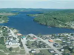 Sainte-Anne-du-Lac and Lake Tapani | |
 Coat of arms | |
_Quebec_location_diagram.png.webp) Location within Antoine-Labelle RCM | |
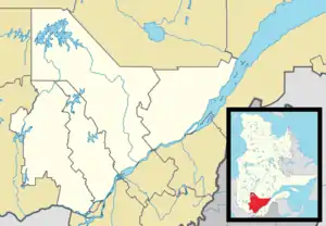 Sainte-Anne-du-Lac Location in central Quebec | |
| Coordinates: 46°53′N 75°20′W[1] | |
| Country | Canada |
| Province | Quebec |
| Region | Laurentides |
| RCM | Antoine-Labelle |
| Settled | 1870s |
| Constituted | December 30, 1976 |
| Government | |
| • Mayor | Jocelyne Lafond |
| • Federal riding | Laurentides—Labelle |
| • Prov. riding | Labelle |
| Area | |
| • Total | 345.73 km2 (133.49 sq mi) |
| • Land | 320.73 km2 (123.83 sq mi) |
| Population (2021)[3] | |
| • Total | 556 |
| • Density | 1.7/km2 (4/sq mi) |
| • Pop. 2016-2021 | |
| • Dwellings | 422 |
| Time zone | UTC−05:00 (EST) |
| • Summer (DST) | UTC−04:00 (EDT) |
| Postal code(s) | |
| Area code | 819 |
| Highways | |
| Website | www |
Sainte-Anne-du-Lac is the northernmost community in the Laurentides region, about 45 km (28 mi) from Mont-Laurier. The village itself is located at the northern terminus of Quebec Route 309, on the south shore of Lake Tapani.
History
Settlement began around 1870. In 1916, the Parish of Sainte-Anne-du-Lac was formed, and the following year, the first school was built. Also in 1917, the Township of Décarie was established, and incorporated as a township municipality in 1920. It was named in honour of Jérémie-Louis Décarie.[1] The township municipality used to extend to the Lièvre River, but the south-eastern portion was ceded in 1928 to the then newly created Municipality of Mont-Saint-Michel.[4]
In 1950, the village itself separated from the township to form the Village Municipality of Sainte-Anne-du-Lac.[1]
On December 30, 1976, the township and village municipalities merged to form the current Municipality of Sainte-Anne-du-Lac.[1]
Demographics
| 2021 | 2016 | |
|---|---|---|
| Population | 556 (-3.3% from 2016) | 575 (-7.1% from 2011) |
| Land area | 320.73 km2 (123.83 sq mi) | 322.59 km2 (124.55 sq mi) |
| Population density | 1.7/km2 (4.4/sq mi) | 1.8/km2 (4.7/sq mi) |
| Median age | 59.6 (M: 60.4, F: 58.0) | 55.5 (M: 57.4, F: 54.4) |
| Private dwellings | 422 (total) | 364 (total) |
| Median household income | $37,760 |
|
| ||||||||||||||||||||||||||||||||||||
| 1991, 1996.[9] 2001, 2006.[10] 2011, 2016[11] | |||||||||||||||||||||||||||||||||||||
Private dwellings occupied by usual residents (2021): 299 (total dwellings: 422)[3]
Mother tongue:
- French as first language: 95.65%
- English as first language: 2.61%
- English and French as first language: 0.87%
- Other as first language: 0.87%
Local government
List of former mayors:
- Aimé Lachapelle (...–2013)
- Annick Brault (2013–2021)
- Jocelyne Lafond (2021–present)
See also
References
- "Reference number 77617 in Banque de noms de lieux du Québec". toponymie.gouv.qc.ca (in French). Commission de toponymie du Québec.
- "Geographic code 79115 in the official Répertoire des municipalités". www.mamh.gouv.qc.ca (in French). Ministère des Affaires municipales et de l'Habitation.
- "Sainte-Anne-du-Lac, Municipalité (MÉ) Census Profile, 2021 Census of Population". www12.statcan.gc.ca. Government of Canada - Statistics Canada. Retrieved 4 July 2022.
- "Reference number 42206 in Banque de noms de lieux du Québec". toponymie.gouv.qc.ca (in French). Commission de toponymie du Québec.
- "2021 Community Profiles". 2021 Canadian Census. Statistics Canada. February 4, 2022. Retrieved 2022-07-04.
- "2016 Community Profiles". 2016 Canadian Census. Statistics Canada. August 12, 2021. Retrieved 2022-07-04.
- "2006 Community Profiles". 2006 Canadian Census. Statistics Canada. August 20, 2019.
- "2001 Community Profiles". 2001 Canadian Census. Statistics Canada. July 18, 2021.
- Population and Dwelling Counts, for Census Agglomerations in Alphabetical Order, 1991 and 1996 Censuses – 100% Data
- 2006 Community Profiles – Yellowknife
- "Census Profile, 2016 Census Sainte-Anne-du-Lac, Municipalité [Census subdivision], Quebec and Antoine-Labelle, Municipalité régionale de comté [Census division], Quebec". Statistics Canada. Retrieved 2020-01-27.
External links
![]() Media related to Sainte-Anne-du-Lac, Laurentides, Quebec at Wikimedia Commons
Media related to Sainte-Anne-du-Lac, Laurentides, Quebec at Wikimedia Commons
Adjacent Municipal Subdivisions | ||||||||||||||||
|---|---|---|---|---|---|---|---|---|---|---|---|---|---|---|---|---|
| ||||||||||||||||
| Cities/towns | |
|---|---|
| Municipalities | |
| Villages | |
| Unorganized territories | |
| |