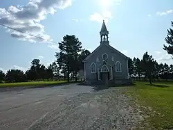
Sainte-Jeanne-d'Arc, Bas-Saint-Laurent, Quebec
Sainte-Jeanne-d'Arc is a parish municipality in La Mitis Regional County Municipality in the Bas-Saint-Laurent region of Quebec, Canada. Its population in the Canada 2021 Census was 217.[2][3]
Sainte-Jeanne-d'Arc | |
|---|---|
 | |
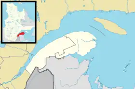
_Quebec_location_diagram.png.webp) Location within La Mitis RCM | |
 Sainte-Jeanne-d'Arc Location in eastern Quebec | |
| Coordinates: 48.4955595°N 67.9615137°W[1] | |
| Country | |
| Province | |
| Region | Bas-Saint-Laurent |
| RCM | La Mitis |
| Constituted | January 30, 1922 |
| Government | |
| • Mayor | Maurice Chrétien |
| • Federal riding | Haute-Gaspésie—La Mitis—Matane—Matapédia |
| • Prov. riding | Matane-Matapédia |
| Area | |
| • Total | 112.80 km2 (43.55 sq mi) |
| • Land | 110.34 km2 (42.60 sq mi) |
| Population | |
| • Total | 217 |
| • Density | 2/km2 (5/sq mi) |
| • Pop 2016-2021 | |
| • Dwellings | 146 |
| Time zone | UTC−5 (EST) |
| • Summer (DST) | UTC−4 (EDT) |
| Postal code(s) | |
| Area code(s) | 418 and 581 |
| Highways | |
| Website | www |
Demographics
In the 2021 Census of Population conducted by Statistics Canada, Sainte-Jeanne-d'Arc had a population of 217 living in 110 of its 146 total private dwellings, a change of -22.5% from its 2016 population of 280. With a land area of 110.34 km2 (42.60 sq mi), it had a population density of 2.0/km2 (5.1/sq mi) in 2021.[4]
Canada census – Sainte-Jeanne-d'Arc community profile
| 2021 | 2016 | 2011 | |
|---|---|---|---|
| Population | 217 (-22.5% from 2016) | 280 (-10.5% from 2011) | 313 (-2.8% from 2006) |
| Land area | 110.34 km2 (42.60 sq mi) | 110.55 km2 (42.68 sq mi) | 109.86 km2 (42.42 sq mi) |
| Population density | 2.0/km2 (5.2/sq mi) | 2.5/km2 (6.5/sq mi) | 2.8/km2 (7.3/sq mi) |
| Median age | 54.8 (M: 54.4, F: 54.8) | 50.4 (M: 48.2, F: 51.1) | 45.7 (M: 47.0, F: 45.1) |
| Private dwellings | 146 (total) | 169 (total) | 149 (total) |
| Median household income | $41,280 | $34,053 |
| Year | Pop. | ±% |
|---|---|---|
| 1931 | 794 | — |
| 1941 | 955 | +20.3% |
| 1951 | 1,037 | +8.6% |
| 1956 | 1,099 | +6.0% |
| 1961 | 1,057 | −3.8% |
| 1966 | 951 | −10.0% |
| 1971 | 720 | −24.3% |
| 1976 | 537 | −25.4% |
| 1981 | 483 | −10.1% |
| 1986 | 451 | −6.6% |
| 1991 | 369 | −18.2% |
| 1996 | 371 | +0.5% |
| 2001 | 354 | −4.6% |
| 2006 | 322 | −9.0% |
| 2011 | 313 | −2.8% |
| 2016 | 280 | −10.5% |
| 2021 | 217 | −22.5% |
References
- "Reference number 56217 in Banque de noms de lieux du Québec". toponymie.gouv.qc.ca (in French). Commission de toponymie du Québec.
- "Geographic code 09020 in the official Répertoire des municipalités". www.mamh.gouv.qc.ca (in French). Ministère des Affaires municipales et de l'Habitation.
- "Tableau de profil, Profil du recensement, Recensement de la population de 2021". 9 February 2022.
- "Population and dwelling counts: Canada, provinces and territories, and census subdivisions (municipalities), Quebec". Statistics Canada. February 9, 2022. Retrieved August 29, 2022.
- "2021 Community Profiles". 2021 Canadian Census. Statistics Canada. February 4, 2022. Retrieved 2022-08-25.
- "2016 Community Profiles". 2016 Canadian Census. Statistics Canada. August 12, 2021. Retrieved 2022-08-25.
- "2011 Community Profiles". 2011 Canadian Census. Statistics Canada. March 21, 2019. Retrieved 2022-08-25.
- "2006 Community Profiles". 2006 Canadian Census. Statistics Canada. August 20, 2019.
- "2001 Community Profiles". 2001 Canadian Census. Statistics Canada. July 18, 2021.
- Statistics Canada: 1996, 2001, 2006, 2011, 2016 , 2021 census
This article is issued from Wikipedia. The text is licensed under Creative Commons - Attribution - Sharealike. Additional terms may apply for the media files.