Saitobaru Kofun Cluster
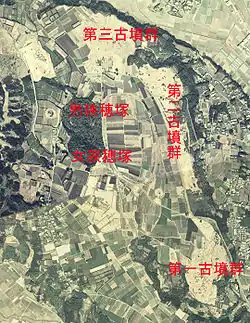
Saitobaru Kofun Cluster (Japanese: 西都原古墳群) is a group of three hundred thirty three kofuns or tumuli in Saito city, Miyazaki Prefecture, Japan. This is one of the largest kofun groups in Japan, and the largest group in Kyushu situated on a 70-meter hill composed of diluvium. It is located within the Saitobaru-Sugiyasukyō Prefectural Natural Park.
General description
The Saitobaru kofungun or Burial Mounds were designated by the national government as a special historical site in 1952. The majority of the tumuli in Saitobaru have yet to be excavated and many remain wrapped in a veil of mystery. There are 311 elevated mounds, (31 keyhole-shaped mound (zenpo-koenfun (前方後円墳), unique to ancient Japan, 1 Houfun (方墳), 279 circular type (empun (円墳)), kofuns) and 10 Yokoana (横穴) kofuns and 12 underground kofuns, the last being peculiar to southern Kyushu. The first scientific excavation was made in 1912. In 1952, Saito City Museum was founded, which was later changed to Miyazaki Prefectural Saitobaru Archaeological Museum.
Important Kofuns
Osahozuka and Mesahozuka
Himezuka Kofun
- A 50-meter-long keyhole-shaped kofun, one of the most beautiful kofuns encircled by a moat and had precious treasures such as swords, vases, glass-balls inside. It was assumed to be built in the early 6th century.
Oninoiwaya Kofun
It was the only sideway kofun which was completely encircled by an earthwork (archaeology). This is unique and reminds one of kofuns in China.
Festival
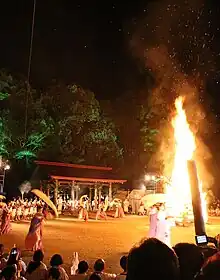
There is an annual festival in november dedicated to the Kofun cluster[6].
Kiki no Michi
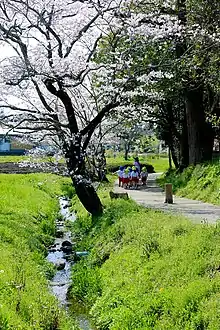
The Kiki no Michi is a sidewalk with a total length of about 4 kilometers (km) in Saito, Miyazaki Prefecture. Kiki refers to Kojiki and Nihon Shoki, and connects places of historical interest related to the Hyūga Myth described in these documents.[7]
Outline
The road received the 2019 Handmade Hometown Award for "Kiki no Michi: Connecting Local Treasures to Nurture the Heart"[8]. From Sosha in Hinata Province, the shrine is said to have been the place where Ninigi-no-Mikoto and Konohanasakuya-hime were newly married. The road leads to Saitobaru Kofun Cluster's male and female mounds (mausoleum reference site) via a legendary place where Konohanasakuya-hime and Ninigi-no-Mikoto are said to have spent their married life together. A section of the road is maintained as a pedestrian-only road.
There are several places in Miyazaki Prefecture that are said to be the setting of the same story, making it difficult to compare these traditional sites. The legend of the Kiki no Michi can be seen in the "Illustrated Map of the Jindai" completed in 1823 by Kokugaku Sanemitsu Kodama in the Edo period, which is thought to have already existed as the legend of Hyuga mythology at that time. It is believed to have already existed at that time as a place of legend of Hyuga mythology. These traditional sites are still carefully preserved by local residents. In addition, Historic sites such as Hyūga Province and a group of ancient tombs are densely located along the Kiki Path, suggesting that this area was the political, economic, and cultural center of Ancient times Hyuga.[9][10]。Nishito-shi is a town where archaeological artifacts and mythological traditions are concentrated, and based on the idea of Mr. Masaharu Hidaka, an archaeologist from Nishito-shi, a road connecting scattered historical sites and folklore was named "Kiki no Michi".[11]。
Several place names remain in the vicinity, such as Tsuma, Koyu, Sakamoto, Ishinuki, and Dojimaru, which are thought to have their roots in Hyuga mythology. One of the traditional places, "Koyu no Ike" is said to have been the origin of the current name of Koyu-gun.[10]。There is also a theory that the land of Tsuman (Tsuma) is a place that is compared to Toumakoku mentioned in Wajinden, and it can be said to be associated with historical books other than the Chronicles of Japan.
The entire area is a prefectural bird and animal sanctuary, and parts of it overlap with the Kyushu Nature Trail, creating a landscape where nature and human settlements coexist.
The Saito Kofun Festival, held every November, features a torchlight procession of several hundred people marching along the Kikki Path.
On May 24, 2018, the Saitobaru Kofun Tumulus Group and other tombs in the surrounding area were recognized as Japanese Heritage as "Monuments of Ancient People - Painting on the Plateau: Kofun Landscape of Miyazaki in Southern Japan", and the Kiki Road became one of the component cultural properties as a complement to the story's subject matter.[12]。
It is the winner of the 2019 Good Design Award for its efforts to protect local residents' traditional landscapes and landscape creation.[13]。
Sites of lore
A series of ten lore sites are located along the Kiki Path, and several lore sites are scattered off the Kiki Path as well.
Lore sites along the path of the Chiki
- Toman Shrine
- Mifunezuka
- Aizomegawa River
- Yahiro-dono (Yahiro-den) site
- Ruins of Mutsu Muro
- Pond of Kodu
- Ishinuki Shrine
- Oyamakizuka Mound
- Oni no grotto
- Male and female mounds
Other places of lore
- Miyake Shrine
- Sasanuki Shrine
- Kakishozuka Shrine
- Dojimaru Shrine
- Ono of Tango-no Ono
Historic Sites and Natural Monuments
- Saitobaru Tumulus Group (Special Historic Site) - In addition to the Saitobaru Plateau, 25 round mounds are scattered among houses and fields in an area known as the Middle Territory, where underground horizontal burial mounds have also been discovered. (Dogashima Branch Group)[14]
- Hyuga Kokufu Ruins (National Historic Site)
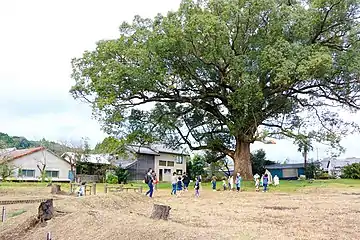
- Tsuma no Kusu (Prefecturally-designated natural monument)
- Ogatama tree in Terasaki area cemetery (city-designated natural monument) - a huge tree of Ogatama tree. It is described as "ogatama tree" in "Jindai no Ezu" and is depicted as a considerably large tree. The tree has a chest-high circumference of 3.9 m, a height of 15 m, and an estimated age of 310 years.[15]
See Also
References
- Osahozuka and Mesahozuka Archived 2012-09-02 at the Wayback Machine
- Osahozuka and Mesahozuka 2 Archived 2012-09-05 at the Wayback Machine
- Saitobaru Burial Mounds
- Japan Atlas, Historic Sites, Cluster of Burial Mounds in Saitobaru
- Japan Cultural Profile, Saitobaru Burial Mounds
- "Saito Burial Mound Festival | 20 Component Cultural Properties". Japan Heritage Kofun landscapes in the southern lands of Miyazaki‐Monuments of the ancients‐. Retrieved 2023-10-19.
- "Why not Come to Miyazaki?-the Mythology world 5days". *** i TRAVEL SQUARE *** (in Japanese). 2019-06-15. Retrieved 2023-05-19.
- "宮崎県受賞一覧 - 国土交通省". www.mlit.go.jp. Retrieved 2023-05-19.
- 『西都市史』通史編上巻、西都市、2016年
- 『西都の歴史』西都市、1976年
- 梅原猛『天皇家の”ふるさと”日向を行く』新潮社、2005年
- "古代人のモニュメント―台地に絵を描く南国宮崎の古墳景観―" (PDF). 日本遺産ポータルサイト. 文化庁. Retrieved 2019-02-19.
- "2019年度グッドデザイン賞". 公益財団法人日本デザイン振興会. Retrieved 2019-10-02.
- 『西都市史』資料編、西都市、2015年
- "西都市の文化財について". 西都市. Retrieved 2019-02-19.
Bibliography
- 『西都の民話』第一巻
- 森浩一『日本神話の考古学』朝日新聞社、1993年
- 児玉実満『神代の絵図』1823年
- 日高正晴『古代日向の国』日本放送出版協会、1993年