Sakar Sar
Sakar Sar is a mountain peak located at 6,272 metres (20,577 ft) above sea level.[2] It lies in the Hindu Kush-Karakoram, in part in the Gilgit-Baltistan region of Pakistan-administered Kashmir and in part in Afghanistan's Wakhan Corridor.
| Sakar Sar | |
|---|---|
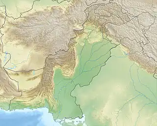 Sakar Sar Location in Gilgit-Baltistan  Sakar Sar Sakar Sar (Gilgit Baltistan) | |
| Highest point | |
| Elevation | 6,272 m (20,577 ft)[1] |
| Coordinates | 36°53′42″N 74°14′30″E |
| Geography | |
| Location | Karakoram |
| Climbing | |
| First ascent | August 13, 1999 by a Japanese team |
The first successful ascent was completed by a Japanese team in August 1999.[3]
Location
Sakar Sar is located 9 km east of the Irshad Pass on the watershed between Wachandarja in the north and Chapursan in the south.[4] The dominance reference point is a 6610 m high mountain in the Karakoram, 2.26 km east of the Koz Sar (6677 m) is located. Also, a few kilometers away is Dilisang Pass, a historic and disused cross-border trading route connecting Kyrgyz people and Wakhi people settlements.[5]
First ascent
On August 13, 1999, a Japanese team consisting of Akira Miyazawa, Makoto Ishikawa, Kanji Kamei, and Teruaki Suzuki and the two carriers reached the summit.[6][3]
References
- "Sakar Sar" on CEP.com.pk Listed as "Sakar Sar". Retrieved 18 August 2021
- "Where are the Hindu Kush Mountains?". WorldAtlas. 10 January 2019. Retrieved 2021-08-18.
- "AAC Publications - Asia, Pakistan, Hispar Muztagh, Sakar Sar, First Ascent". publications.americanalpineclub.org. Retrieved 2021-08-18.
- "Attractions :: Gilgit Baltistan". visitgilgitbaltistan.gov.pk. Retrieved 2021-08-18.
- "2004 Mock & O'Neil Wakhan Expedition Report". www.mockandoneil.com. Retrieved 2021-08-18.
- 2000 American Alpine Journal. The Mountaineers Books. ISBN 978-1-933056-47-0.