Salt Lake meridian
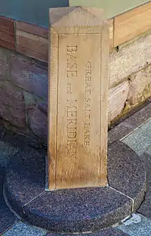
The Salt Lake meridian, established in 1855, in longitude 111° 54′ 00″ west from Greenwich, has its initial point at southeast corner of Temple Square, in Salt Lake City, Utah, extends north and south through the state, and, with the base line, through the initial, and coincident with the parallel of 40° 46′ 04″ north latitude, governs the surveys in the territory, except those referred to the Uintah meridian and Baseline projected from an initial point in latitude 40° 26′ 20″ north, longitude 109° 57′ 30″ west from Greenwich.

The Great Salt Lake Base and Meridian
See also
References
- Raymond, William Galt (1914). Plane Surveying for Use in the Classroom and Field (via Internet Archive). New York: American Book Company.
External links
- "Cadastral Survey [Salt Lake meridian]". U.S. Bureau of Land Management. Retrieved 2012-10-03.
- "Principal Meridians and Base Lines". U.S. Bureau of Land Management. Archived from the original on 2012-10-18. Retrieved 2012-10-03.
- "Great Salt Lake Meridian, Salt Lake, UT". Principal Meridian Project. Retrieved 2012-10-03.
- "Salt Lake Meridian". The Center for Land Use Interpretation. Retrieved 2012-10-03.
- Historic American Engineering Record (HAER) No. UT-36, "Great Salt Lake Base and Meridian, Temple Square, Salt Lake City, Salt Lake County, UT", 1 photo, 1 data page, 1 photo caption page
This article is issued from Wikipedia. The text is licensed under Creative Commons - Attribution - Sharealike. Additional terms may apply for the media files.