San Diego volcanic field
The San Diego volcanic field is an extensive volcanic field on the El Salvador–Guatemala border of Central America. It consists of a group of basaltic cinder cones and lava flows, with the largest feature being Volcán de San Diego after which the volcanic field is named.[1]
| San Diego volcanic field | |
|---|---|
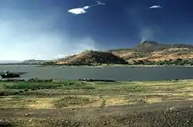 Lake Güija with Volcán de San Diego in the upper right | |
| Highest point | |
| Peak | Cerro el Shiste |
| Elevation | 781 m (2,562 ft) |
| Coordinates | 14°24′N 89°34′W |
| Geography | |
| Country | El Salvador/Guatemala |
| State | Santa Ana Department/Jutiapa Department |
| Geology | |
| Volcanic arc | Central America Volcanic Arc |
| Last eruption | Unknown |
Volcanism in the San Diego volcanic field took place north and east of Lake Güija which is dammed by a large basaltic lava flow from Volcán de San Diego. The volcanic field remains undated but may have been active within the last few thousand years.[1]
Volcanoes
The San Diego volcanic field includes the following volcanoes:
| Name | Landform | Elevation | Coordinates |
|---|---|---|---|
| Cerro la Chata | Lava cone | 746 m (2,448 ft) | 14°24′N 89°34′W |
| Laguneta Clara | Pyroclastic cone | 480 m (1,570 ft) | 14°18′N 89°28′W |
| Loma la Culebra | Pyroclastic cone | 572 m (1,877 ft) | 14°20′N 89°36′W |
| Loma Iguana | Pyroclastic cone | 521 m (1,709 ft) | 14°17′N 89°30′W |
| Cerro Junquillo | Pyroclastic cone | 640 m (2,100 ft) | 14°20′N 89°35′W |
| Cerro Masatepeque | Pyroclastic cone | 540 m (1,770 ft) | 14°18′N 89°29′W |
| Cerro de Ostúa | Pyroclastic cone | 580 m (1,900 ft) | 14°19′N 89°35′W |
| Loma los Pajalitos | Pyroclastic cone | 500 m (1,600 ft) | 14°18′N 89°30′W |
| Cerro Quemado | Pyroclastic cone | 460 m (1,510 ft) | 14°15′N 89°28′W |
| Cerro el Shiste | Lava cone | 780 m (2,560 ft) | 14°24′N 89°34′W |
| Cerro el Tule | Cone | 468 m (1,535 ft) | 14°15′N 89°29′W |
| Cerro la Vega de la Caña | Pyroclastic cone | 465 m (1,526 ft) | 14°17′N 89°30′W |
References
- "San Diego". Global Volcanism Program. Smithsonian Institution. Retrieved 2021-06-18.
This article is issued from Wikipedia. The text is licensed under Creative Commons - Attribution - Sharealike. Additional terms may apply for the media files.