San Rafael del Yuma
San Rafael del Yuma is a municipality located in the La Altagracia province of the Dominican Republic. It has a population of approximately 46,687 in 2012. The ruins of Juan Ponce de León's residence are located on a plateau located three kilometers from San Rafael de Yuma. The municipality is located 10 kilometers from Boca de Yuma.
San Rafael del Yuma | |
|---|---|
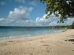
 The beach of Boca de Yuma | |
 Seal | |
 San Rafael del Yuma | |
| Coordinates: 18°27′12″N 68°42′36″W | |
| Country | Dominican Republic |
| Province | La Altagracia |
| Founded | 1608 |
| Municipality since | 1904 |
| Area | |
| • Total | 981.2 km2 (378.8 sq mi) |
| Elevation | 26 m (85 ft) |
| Population (2012)[2] | |
| • Total | 46,687 |
| • Density | 48/km2 (120/sq mi) |
| • Demonym | Yumense(a) |
| Municipal Districts | 2 |
Climate
| Climate data for San Rafael del Yuma (1961–1990) | |||||||||||||
|---|---|---|---|---|---|---|---|---|---|---|---|---|---|
| Month | Jan | Feb | Mar | Apr | May | Jun | Jul | Aug | Sep | Oct | Nov | Dec | Year |
| Record high °C (°F) | 34.5 (94.1) |
34.0 (93.2) |
36.0 (96.8) |
36.5 (97.7) |
36.5 (97.7) |
37.8 (100.0) |
39.1 (102.4) |
39.5 (103.1) |
38.6 (101.5) |
36.5 (97.7) |
35.2 (95.4) |
35.0 (95.0) |
39.5 (103.1) |
| Average high °C (°F) | 29.4 (84.9) |
29.9 (85.8) |
31.2 (88.2) |
32.0 (89.6) |
32.6 (90.7) |
33.2 (91.8) |
33.9 (93.0) |
33.9 (93.0) |
33.7 (92.7) |
32.6 (90.7) |
31.0 (87.8) |
29.9 (85.8) |
31.9 (89.4) |
| Average low °C (°F) | 19.1 (66.4) |
19.1 (66.4) |
19.9 (67.8) |
20.3 (68.5) |
22.0 (71.6) |
22.3 (72.1) |
22.9 (73.2) |
23.0 (73.4) |
22.7 (72.9) |
22.2 (72.0) |
21.0 (69.8) |
19.8 (67.6) |
21.2 (70.2) |
| Record low °C (°F) | 12.8 (55.0) |
12.3 (54.1) |
12.1 (53.8) |
10.5 (50.9) |
15.0 (59.0) |
16.0 (60.8) |
16.0 (60.8) |
15.5 (59.9) |
18.1 (64.6) |
18.2 (64.8) |
14.5 (58.1) |
14.0 (57.2) |
10.5 (50.9) |
| Average rainfall mm (inches) | 77.3 (3.04) |
59.7 (2.35) |
70.7 (2.78) |
71.7 (2.82) |
178.3 (7.02) |
98.2 (3.87) |
95.5 (3.76) |
121.7 (4.79) |
149.6 (5.89) |
202.4 (7.97) |
144.9 (5.70) |
95.9 (3.78) |
1,365.9 (53.78) |
| Average rainy days (≥ 1.0 mm) | 9.6 | 8.3 | 7.7 | 6.8 | 11.3 | 9.7 | 10.7 | 10.9 | 11.1 | 13.7 | 11.5 | 11.7 | 123.0 |
| Source: NOAA[3] | |||||||||||||
Sectors
The city is divided into 16 sectors that are,
- Banda Abajo
- Bayahíbe
- Bejucal Abajo
- Boca del Yuma
- Cabo Falso
- Coral
- Gato
- Jaragua Abajo
- La Piñita
- Las Joyas del Mar
- Mata Chalupe
- Punta Papayo
- San José del Yuma
- San Rafael
- Yuma Abajo
- Yuma Arriba
References
- Superficies a nivel de municipios, Oficina Nacional de Estadistica Archived 2009-04-17 at the Wayback Machine
- Censo 2012 de Población y Vivienda, Oficina Nacional de Estadistica
- "San R. Yuma Climate Normals 1961-1990". National Oceanic and Atmospheric Administration. Retrieved September 19, 2016.
Wikimedia Commons has media related to San Rafael del Yuma (La Altagracia).
This article is issued from Wikipedia. The text is licensed under Creative Commons - Attribution - Sharealike. Additional terms may apply for the media files.