Sanchong metro station
Sanchong (Chinese: 三重) is a station of the Zhonghe–Xinlu line on Taipei Metro and the Taoyuan Airport MRT located in Sanchong District, New Taipei, Taiwan.[2] The station opened for service on 5 January 2012.[3] It is a transfer station with the Taoyuan Airport MRT, which opened on 2 March 2017.
Sanchong 三重 | |||||||||||||||||||||
|---|---|---|---|---|---|---|---|---|---|---|---|---|---|---|---|---|---|---|---|---|---|
 | |||||||||||||||||||||
| General information | |||||||||||||||||||||
| Location | B1 36 Jieyun Rd Sanchong, New Taipei Taiwan | ||||||||||||||||||||
| Operated by | |||||||||||||||||||||
| Line(s) |
| ||||||||||||||||||||
| Connections | Bus stop | ||||||||||||||||||||
| Construction | |||||||||||||||||||||
| Structure type | Underground/Elevated | ||||||||||||||||||||
| History | |||||||||||||||||||||
| Opened | 2012-01-05 | ||||||||||||||||||||
| Key dates | |||||||||||||||||||||
| 2017-03-02 | Airport MRT added | ||||||||||||||||||||
| Passengers | |||||||||||||||||||||
| Taipei Metro: daily (December 2020)[1] | |||||||||||||||||||||
| Rank | Taipei Metro: 99 out of 109 | ||||||||||||||||||||
| Services | |||||||||||||||||||||
| |||||||||||||||||||||
| Sanchong metro station | |||||||||||||
|---|---|---|---|---|---|---|---|---|---|---|---|---|---|
| Chinese | 三重 | ||||||||||||
| |||||||||||||
| Alternative Chinese name | |||||||||||||
| Chinese | 三重埔 | ||||||||||||
| |||||||||||||
Station overview


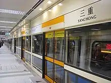
The Orange Line section is a four-level, underground station has an island platform.[4] It is located beneath Jieyun Rd., Lane 3 and Shuhong East Rd, near the Erchong flood diversion channel.[5] It was scheduled to open in March 2012 along with most of the Xinzhuang Line,[6] but opened for service earlier on 5 January 2012.[3]
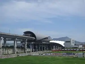
Sanchong station is a transfer station with the Taoyuan Airport MRT, which is a four-level, elevated station with an island platform.[7]
Construction
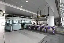
Excavation depth for this station is 19.2 m (63 ft). It is 221.4 m (726 ft) in length and 21.55 m (70.7 ft) wide.[8] It has three entrances, one accessibility elevator, and three vent shafts.[4] Two of the entrances are located next to a joint development lot. An 8,000 m2 (86,000 sq ft) plot of land beside the station is being set aside for joint development projects.[5] The entrance features a double arch-shaped glass roof.
Design
The Line 6 station design is based on a theme of "Waterfront Green Land" with walls and floors inlaid with various materials to form patterns (such as rushing water).[5]
Station layout

| 4F | Platform 1 | ← Airport MRT Commuter toward Huanbei (New Taipei Industrial Park) ← Airport MRT Express does not stop here |
| Island platform, doors will open on the left | ||
| Platform 2 | Airport MRT Commuter toward Taipei (terminus) → Airport MRT Express does not stop here → | |
| 2F | Lobby | Station lobby, information counter, automatic ticket machines, faregates |
| Street Level | Entrance/Exit | Entrance/Exit |
| B3 | Concourse | Lobby, information desk, automatic ticket dispensing machines, one-way faregates |
| Restrooms (Inside fare zone, outside fare zone near exit 1) | ||
| B4 | Platform 1 | ← |
| Island platform, doors will open on the left | ||
| Platform 2 | → | |
Exits
- Exit 1: No. 36, Jieyun Rd., near Shuhong E. Rd.

- Exit 2: Jieyun Rd. (near Lane 22)
- Exit 3: Jieyun Rd. (near Lane 19)
Around the station
- Erchong Floodway
- Erchong Floodway Park
- Jimei Elementary School
- Sanchong High School
- New Taipei Bridge
- Chongxin Bridge
- Zhongxing Bridge
- New Taipei Metropolitan Park
References
- "Passenger Volume at Taipei Rapid Transit Stations". Taipei Mass Rapid Transit Co., Ltd. 2021-01-15.
- "Sanchong". Taipei Rapid Transit Corporation. Retrieved 2012-01-07.
- "MRT Xinzhuang line begins commercial service". Focus Taiwan News Channel. 2012-01-05. Retrieved 2012-01-05.
- "Introduction to Xinzhuang MRT Line" (PDF). Department of Rapid Transit Systems. 2008-03-01. Archived from the original (PDF) on 2013-09-21. Retrieved 2010-06-17.
- "( O5 ) Sanchong". Comprehensive Planning Division, Civil Engineering and Architectural Design Division. 2008-11-19. Retrieved 2010-08-17.
- 黃村杉 (2010-03-18). "北縣/捷運新莊線搶先通 市民「樂」官員「愁」". NOWnews. Retrieved 2010-06-22.
- "A2車站影片簡介". MRT Engineering Office, Bureau of High Speed Rail, MOTC. Retrieved 2010-12-01.
- "捷運車站建築設計 後續路網 新莊線-縣轄段各車站透視圖說明". Department of Rapid Transit Systems. Retrieved 2010-08-01.