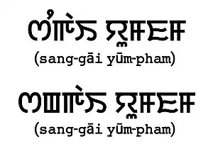
Sanggaiyumpham, Thoubal
Sanggaiyumpham (Sangaiyumpham) or Sanggai Yumpham (Sangai Yumpham) is a village in Thoubal district of Manipur.[1][2]
Sanggaiyumpham
(Sangaiyumpham) Meitei: Sanggāi Yūm-pham | |
|---|---|
Village | |
| Sangaiyumpham | |
| Coordinates: 24.5928159°N 94.0107956°E | |
| Country | |
| State | Manipur |
| District | Thoubal district |
| Government | |
| • Type | Democracy |
| • Body | Government of Manipur |
| Language(s) | |
| • Official | Meitei language (Manipuri language) |
| Pincode | 795148 |
Etymology
In Meitei language, "sanggāi" (Meitei: ꯁꯡꯒꯥꯏ, romanized: /səŋ.gai/) means residence or home, used in formal context.[3] The term "sangāi" (Meitei: ꯁꯉꯥꯏ, romanized: /sə.ŋai/) is the Meitei name of the brow-antlered deer, scientifically known as Cervus eldi eldi.[4] The Meitei term "yumpham" (Meitei: ꯌꯨꯝꯐꯝ, romanized: /yúm.pʰəm/) literally means "the place where a house is built". Morphologically, "yum‑pham" can be divided into two root words, "yum" (Meitei: ꯌꯨꯝ, romanized: /yúm/) and "pham" (Meitei: ꯐꯝ, romanized: /pʰəm/), meaning "house" and "place" respectively.[5]

The Meitei language (officially called Manipuri language) way of writing the name "Sangaiyumpham" in Bengali script is সাঙ্গাইয়ুমফম or সঙ্গাইয়ুমফম while the Bengali language way of writing the same name in the same script is সাঙ্গাইউম্ফাম. In Meitei script, the name is written as ꯁꯡꯒꯥꯏ ꯌꯨꯝꯐꯝ or ꯁꯪꯒꯥꯏ ꯌꯨꯝꯐꯝ.[lower-alpha 1]
Notes and references
- Meitei language (officially called Manipuri language) uses both Meitei script as well as Bengali script predominantly as well as officially.
- "Sangaiyumpham Pin Code, Sangaiyumpham , Thoubal Map , Latitude and Longitude , Manipur". Retrieved 2022-09-29.
- "SANGAIYUMPHAM Pin Code - 795148, Nil All Post Office Areas PIN Codes, Search THOUBAL Post Office Address". Retrieved 2022-09-29.
- Sharma, H. Surmangol (2006). "Learners' Manipuri-English dictionary (Definition of "sanggāi")". dsal.uchicago.edu. University of Chicago. Retrieved 2022-09-29.
- Sharma, H. Surmangol (2006). "Learners' Manipuri-English dictionary (Definition of "sangāi")". dsal.uchicago.edu. University of Chicago. Retrieved 2022-09-29.
- Sharma, H. Surmangol (2006). "Learners' Manipuri-English dictionary (Definition of "yumpham")". dsal.uchicago.edu. University of Chicago. Retrieved 2022-09-29.
External links
- "সাঙ্গাইয়ুমফম হায়র সেকেন্ডারি স্কুল | থৌবাল ডিষ্ট্রিক্ট, মণিপুর গোর্ভরমেন্ট | India" (in Manipuri). Retrieved 2022-09-29.
- "Sangaiyumpham Hr. Sec. School (Govt) | Thoubal District, Government of Manipur | India". Retrieved 2022-09-29.
- Sangaiyumpham at Internet Archive