Olivais, Lisbon
Olivais (Portuguese pronunciation: [oliˈvajʃ]) is a freguesia (civil parish) and district of Lisbon, the capital of Portugal. Located in eastern Lisbon, Olivais is west of Parque das Nações, north of Marvila and Alvalade, and east of Lumiar and Santa Clara. The population in 2021 was 32,179.[1][2]
Olivais | |
|---|---|
_(cropped).jpg.webp) 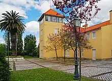 %252C_Lisbon%252C_Portugal_(51323558287).jpg.webp) _(cropped).jpg.webp) .jpg.webp)  Clockwise: Monument to João Maria Ferreira do Amaral; Viscondessa dos Olivais Square; Lisbon Airport; Olivais Philharmonic Society; Santa Maria dos Olivais Church; Municipal Library of Olivais | |
 Coat of arms | |
_localiza%C3%A7%C3%A3o.svg.png.webp) | |
| Coordinates: 38.774°N 9.118°W | |
| Country | |
| Region | Lisbon |
| Metropolitan area | Lisbon |
| District | Lisbon |
| Municipality | Lisbon |
| Area | |
| • Total | 8.09 km2 (3.12 sq mi) |
| Population (2021) | |
| • Total | 32,179 |
| • Density | 4,000/km2 (10,000/sq mi) |
| Time zone | UTC±00:00 (WET) |
| • Summer (DST) | UTC+01:00 (WEST) |
| Patron | Saint Mary |
| Website | www |
History
Kingdom of Portugal and incorporation into Lisbon (1147 - 1886)
The parish was created in 1397, probably resulting in the division of a part of Beato (to the south) and Sacavém (to the north) thanks to the intervention of the first bishop of Lisbon João Anes (bishop).[3]
The parish was duly sanctioned through a papal bull issued on the 1st of July in 1400 by Pope Boniface IX.
The creation of this new ecclesiastical entity was orchestrated by incorporating territory from the Lisbon Term. It is worth noting that these lands, long before their inclusion in the Parish of Olivais, had previously comprised the outskirts of the city, situated beyond Chelas. The Marvila district, once home to Moorish mosques, had been in the possession of the bishopric since the year 1149. Furthermore, it is presumed that this land may have also been affiliated with the Parish of Sacavém, which was established in the 12th century, potentially encompassing the areas of Marcos, Encarnação, and Portela. The demarcation of boundaries in this regard was somewhat vague and subject to fluctuation.
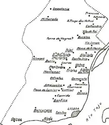
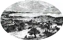
A map of the Lisbon Term from the year 1527 provides a visual representation of this historical context.
Granted to the capital city in 1385 by the benevolent D. João I, as a token of gratitude for services rendered to the nation and the monarchy, this Lisbon Term, in essence, extended as follows: encompassing the entire expanse of the kingdom from the western coastline along the Atlantic Ocean, to the south along the same ocean and the Tagus River, to the east along the Tagus River, and demarcated to the north, conceivably, by the Alcabrichel River on the ocean side, and the Ota River on the Tagus side. Consequently, the area that would later evolve into the parish in question fell under the administrative and policing jurisdiction of the city of Lisbon. This state of affairs endured until the 19th century.[5]
While this donation by the Master of Avis was undeniably advantageous for Lisbon, it gave rise to dissatisfaction among those who had vested interests incorporated within it. Notably, D. Nuno Álvares Pereira, the lord of the reguengos of Sacavém, Unhos, Frielas, and Charneca, voiced his grievances to the monarch. However, through a letter of sentence issued on the 13th of April in 1429, the wise king adeptly addressed the concerns of this distinguished military figure, reconciling their respective interests. In his ruling, the monarch declared, "we judge that the said city exercises jurisdiction over the said places freely, unencumbered by the letters of donation presented by the said count, and without prejudice to him in this matter." ("julgamos q.a dita cidade aja as jurisdições dos ditos lugares liuremente, e husse dellas sem embargo das cartas das doações mostradas da parte do dito conde (estabre), e ssem embargo daquilo q. da sua parte he dito").[6]
The exact date of the construction of the parish church remains unknown. Nevertheless, given the year of the parish's formation, we can place it at least in the 14th century, although there are no records of its founders. The story, preserved in tradition, that the patron saint's image was found within the hollow of an olive tree trunk, leading to the naming of the new jurisdiction as Nossa Senhora or Santa Maria dos Olivais, appears to be of a legendary nature. However, the said trunk, which the vicar of the time had ordered to be uprooted and preserved, was kept in the sacristy until 1700.[7][8]
In 1420, at the invitation of the vicar himself, the Congregation of Secular Canons of Saint John the Evangelist had their first temple there. However, this priest's hospitality ended with the expulsion of the friars, likely due to personal differences, and for this or other reasons, Archbishop D. Jorge da Costa united the church with the chapel of Nossa Senhora da Conceição at the Lóios Convent, near the São Jorge Castle of Lisbon, where they had been since 1442. Until 1834, the tithes of the parish belonged to the Lóios Convent. The church of Olivais became or already was a "vicarage, presented by the Rector of the Santo Eloy Convent."[9]
These were the beginnings of an era when the parish, as noted by Gomes de Brito, was a "repository of youthful affections, pious beliefs, grateful and salutary memories" and, at the same time, a "sacred ground where fathers, brothers, sons, and wives slept beneath the gravestones," serving as a focal point for collective attraction and strong, enduring bonds.[10]
Indeed, countless hours, both solemn and joyful, were spent under the welcoming roof of the Virgin Mary, while a multitude of bodies found their resting place in the church and its courtyard, where weathered gravestones, especially in the main altar area, still bear the names of respectable figures from the jurisdiction. Particularly notable are the two side chapels of the nave, one on the left dedicated to Gomes Alpoim de Brito and his family, with the tomb located at the rear, and the one on the right, more recently used, presumably by Diogo de Brito Delgado and family members residing in Panasqueira, possibly succeeding another older owner.
Holy water fonts on either side of the porch confirm the ownership of the two chapels, with their heraldic shields carved on them. In the left one, there are the Alpoim arms, and in the right, an unidentified coat of arms, perhaps belonging to one of the Esteves families in the vicinity, one of which had its roots at Fonte da Pipa, or possibly the aforementioned Brito Delgado family, connected to the Ataídes family, and in this case, with no prior bearers before them. Gomes Alpoim de Brito, who obtained his coat of arms on November 17, 1573, and was married to his cousin, D. Ana de Figueiroa de Barros, was the grandson of Amador Alpoim, the royal finance clerk of D. Duarte, president of the Municipal Senate, and founder of the Morgado dos Marcos, headquartered at the Quinta dos Alpoins. He was widowed in 1609 and passed away on August 25, 1621, being the husband of D. Ana de Barros.
The proximity to Lisbon benefited the new parish, whose area witnessed numerous settlements. However, in return, the central area occupied by the church experienced slow progress in contrast to the more rapid development of peripheral zones, especially those along the Tagus River on this side of Cabo Ruivo, which had been considered beautiful environs of Lisbon from the beginning.[11]
Nevertheless, the chosen location for building the temple, which was restored in the 16th and 17th centuries, reconstructed after 1755, and renovated again in the 19th century, is roughly equidistant from the boundaries of Sacavém and the beach (entry and exit points). It overlooks the kneeling valley, until recently, at the foot of Vale Formoso de Cima, Laje, and Aldeia. This choice doesn't seem purely coincidental.
It is believed that Nossa Senhora dos Olivais owes its existence to the requests of the local population, given the difficulty of attending religious services in the distant churches of Lisbon and Sacavém, which were heavily dependent on poor transportation, particularly during the winter. This was the case with Charneca on November 6, 1511, where three brotherhoods served the parish under the names of Nossa Senhora do Rosário, das Almas, and do Santíssimo, with only the latter still in existence today. The same applied to Camarate in terms of the number and names of confraternities.
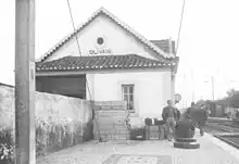
The construction of the railway in 1856 triggered the establishment of industries that benefited from both the proximity to the railway line and the nearby river port of Olivais, which remained complementary to rail transport for a considerable period.
.jpg.webp)
Following the undeniable trend that progressive urban centers tend to absorb neighboring rural areas, the municipality began to decline toward the end of the 19th century.
Fragmented and gradually parceled into a scarcely profitable domain, the Parish of Olivais, until the end of the 19th century, represented an attractive enclave for the Lisbon aristocracy. Alas, it fell victim to the inevitable tide of progress, much like its neighboring parishes. It was, fundamentally, a place of leisure, frequented for holidays and, much later, retreats, renowned along the Road to Sacavém. Despite its crucial role in supplying the city, it naturally became a target for Lisbon's expansion, albeit through a gradual process of annexation. The following phases emerged from this process, on the peripheral fringes of the parish, intrinsic to its involvement in the Lisbon Term.
Firstly, the law of August 20, 1654, annexed the parishes of the Term to the neighborhoods of Lisbon for the purposes of law enforcement and criminal prosecution, without, however, incorporating them within their jurisdiction. Subsequently, the position of Corregedor do Crime (Crime Magistrate) of the Term was abolished, subjecting the 42 judicatures he oversaw to the jurisdiction of the city's magistrates, naturally including that of Olivais.
.jpg.webp)
At that time, a substantial portion of the Olivais parish was commonly regarded as integrated into the capital, so intertwined were the extremities of both, and so enriched were the former by their lucrative association with the latter.[12]

Nonetheless, the boundaries of the splendid city, established by decree on December 3, 1755, and confirmed by royal decree on May 12, 1758, extended from the Tejo River to Santa Apolónia on one side, with Olivais bordering the Vale de Chelas. On the Sacavém side, the delineations of the parish encompassed Marcos, Encarnação, Portela, and the Road to Sacavém, in the vicinity of Bela Vista.[13]
In 1756, a relatively short period later, the vast eastern territory was carved out for the first time with the establishment of the new parish of Beato, which encompassed Chelas, Fonte do Louro up to Cruz do Almada, Rua Direita de Marvila, Grilo, Beato, and Poço do Bispo. Officially established in 1770, this valuable jurisdiction was altered by the 1780 plan, which returned Rua Direita de Marvila to Olivais. In 1811 and 1834, it participated in the city's division into 13 neighborhoods, featuring prominently in Alfama.[14]
Following a judicial division approved by decree on August 7, 1835, it was structured into six judicatures, each with its own Term. The Alfama neighborhood judicature comprised the parishes of São Bartolomeu da Charneca, Campo Grande, São João da Talha, Santa Iria da Azoia, Olivais, Sacavém, São Tiago dos Velhos, and Vialonga. On May 21, 1841, these arrangements served as the basis for a new administrative division of Lisbon, now reduced to six neighborhoods, with Olivais also participating in Alfama.
.jpg.webp)
The Municipality of Olivais was created by decree on September 11, 1852, issued by the Ministry of the Kingdom, which established new boundaries for the city of Lisbon.
Until municipal elections were held, the civil governor of Lisbon would appoint an Administrative Committee for the new municipality, endowed with the functions typically assigned to municipal councils. However, all the responsibilities conferred by laws and regulations regarding census and elections, until these took place, would be exercised in the Municipality of Olivais by the Municipal Council of Lisbon.
Furthermore, the government would designate a state building to serve as the Town Hall for the new municipality. The administration of properties that Lisbon held within the annexed territory would continue to belong to Lisbon. The revenue from municipal taxes that the Lisbon Municipal Council had acquired through auction until the establishment of the Municipality of Olivais would still be collected by the respective Municipal Council until the end of the respective auctions. The government also committed to annually provide the Municipality of Olivais with a sum equivalent to the expenses incurred by the Lisbon Municipal Council in the territory of the newly created municipality related to public lighting and road maintenance, until these matters were regulated. Finally, the Civil Governor of Lisbon would provisionally determine, within 60 days, the new municipality's boundaries, which, after a year, would become definitive, subject to a proposal from the same governor, accompanied by information from the competent authorities and any received complaints, a proposal contingent upon government confirmation or alteration.[15] Between 1852 and 1886 Santa Maria dos Olivais formed a large municipality, predominantly rural, including 22 civil parishes.

It covered an area of approximately 223 square kilometers and had a population of 25,495 inhabitants in 1864,
which increased to 29,491 inhabitants by 1878.
The headquarters of the Olivais Municipal Council were situated at Largo do Leão in São Jorge de Arroios. This building still stands today, currently housing the Professional School of Arts, Technologies, and Sports (EPAD), after serving as a primary school for many years.
Indeed, by a decree dated July 18, 1885, the Lisbon municipality annexed the parishes of Beato, Charneca, Ameixoeira, Lumiar, Campo Grande, and even the parish of Olivais to the Municipality of Olivais.
Following the dissolution of the Belém municipality, the parishes of Carnide and Odivelas were temporarily incorporated into the Municipality of Olivais, albeit for only one year. In 1886, the southernmost parishes were integrated into the city of Lisbon, and the following year, the municipality's seat was relocated to the town of Loures, thereby formally dissolving the Municipality of Olivais and establishing the new Municipality of Loures. The parish of Santo Estêvão das Galés became part of the Mafra municipality.
The Olivais Municipal Council convened for the last time in its official capacity at the Town Hall, now situated outside its boundaries at Largo do Leão, on December 30, 1886. The council members included the following: President, Barão de Vale Formoso, Tomás António Barbosa Leitão; Vice-President, João Antunes Pomba; and Councillors, Manuel Rodrigues Azevedo, Olegário Luís António de Sousa, Joaquim Marques Ferreira, Fernando Silvestre Alves, and Francisco Pereira Pedroso. On January 2, 1887, the council administered the oath of office to the new Municipal Council of Loures in the same location. On the 3rd of January, the same council convened an extraordinary meeting to address various matters, including urgent contracts, public lighting, municipal personnel, and the cleanliness of some parishes. The first regular session took place on January 7, with the council remaining at the "extinct" Municipality of Olivais until July. The session on the 7th was conducted in the council's own premises at the Palácio dos Marqueses da Praia in the Mealhada district.
Additionally, on a temporary basis, the parishes of Camarate and Sacavém (intramuros) remained within the jurisdiction of Lisbon until 1895 when they permanently transitioned to the Loures municipality.
Urbanization and new boundaries (1886-2012)
On September 26, 1895, a decree was approved that separated the extramural part of the Sítio dos Marcos from the Olivais Parish and joined it to the newly created Loures Municipality. Later, by Decree No. 15,222 dated March 23, 1928, the extramural part of the Sítio dos Marcos became the Moscavide Parish.[16]
Beginning in 1903, the city's last fiscal checkpoint was established in the former jurisdiction established by D. João Anes. It had posts in Encarnação, with the building located in front of the local church (which was demolished in 1940); Quinta do Cabeço; Moscavide; Rua Conselheiro Mariano de Carvalho, No. 5 to 7; Cabo Ruivo, with its location in Vale Formoso de Baixo at No. 198-A (since demolished); Braço de Prata, in front of the Arco das Panelas; and Beato, with a building in Marvila.
1940 saw the construction of the first structures of Lisbon Airport, in fact, significant part of the territory of the Olivais parish is occupied by said airport. Humberto Delgado Airport served approximately 28.4 million passengers in 2022, being the busiest airport in Portugal, the fourth busiest in the Iberian Peninsula and the 14th busiest in Europe.[17][18]


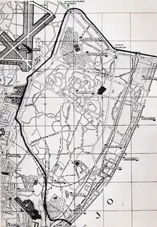
On February 7, 1959, a decree was approved that altered the administrative division of Lisbon, creating new parishes and adjusting existing ones. As a result, the massive Olivais parish was reduced to the following boundaries: "Starting from the edge of the Tejo River near Cabo Ruivo, it follows northwest along the axis of Lisbon's Second Circular Road. After passing the airport roundabout, it continues for about 1100 meters along the projected axis of the aforementioned circular road until it reaches the point closest to the same circular road, near the longest runway of Lisbon Airport (N.E.-S.W.). From here, it continues, skirting the airport, along the western side (along the edge of the lands reserved by the Directorate-General of Civil Aviation for the expansion of runways) until it reaches the circumferential road that limits the city and the municipality of Lisbon. It then continues east along the municipal boundary until it reaches the Tejo River. Finally, it turns south, following the riverbank until the starting point." [19]
.jpg.webp)
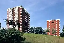
In the second half of the XX century the parish experienced sustained demographic growth. During this period many buildings were built, with contribution also from renowned Portuguese architects such as Cândido Palma de Melo, José Rafael Botelho and Raul Hestnes Ferreira.
.jpg.webp)
In the 1960s, with the occupation of regional properties already in the possession of the Lisbon Municipal Council, the parish gained in terms of real estate and population what it had gradually lost in proportion, shedding its rustic characteristics and picturesque divisions that had been maintained for nearly 600 years. The parish became an highly urbanized area located within the historic region of Estremadura.
.JPG.webp)
In 1960 the Olivais swimming pool opened. It was the first swimming pool in Portugal to have an Olympic-sized pool. Along with swimming pools in Areeiro and Campo Grande, it is considered exemplary of 1960s Portuguese architecture.The swimming pool was built as an outdoor pool complex according to plans by the architects Eduardo Paiva Lopes and Aníbal Barros da Fonseca. It lies in the valley between the neighborhoods of Olivais Sul and Encarnação on Avenida de Berlim. The sports complex closed in 2006 but was heavily expanded (it now houses four swimming pools as well as other sports facilities) in 2015.[20][21][22][23]
In 1998 Olivais and Cabo Ruivo metro stations opened to the public, being the first two stations of Lisbon metro ever built in Olivais parish. Their inauguration coincided with Expo 1998.
Infrastructure development (2012 - present)
_2011-2012.svg.png.webp)
In 2012, as part of the administrative reorganization of the city of Lisbon, the parish of Santa Maria dos Olivais (then renamed to the Parish of Olivais) was subdivided, losing approximately 25% of its territory (the waterfront area of the former Expo '98) to the new parish of Parque das Nações. Additionally, it underwent some adjustments in its boundaries with neighboring parishes.[24][25]
In 2012 three additional stations of Lisbon metro opened in the parish. They are, respectively, Moscavide, Encarnação and Aeroporto. The latter connects Lisbon airport with the city centre, making travel between the two extremely easy.
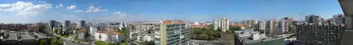
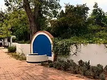
Landmarks

.jpg.webp)
Local landmarks include:
- António Damásio High school: Built in 2011, it was distinguished with an Honorable Mention in the 2011 Valmor and Municipal Architecture Prize
- Bartolomeu de Gusmão statue: Monument inaugurated in 1973[26]
- Capela da Quinta da Fonte do Anjo
- Casa da Fonte do Anjo
- Casa da Quinta do Policarpo, also known as Benagazil Palace, was built on the initiative of the politician and entrepreneur Policarpo José Machado (1796-1875)
- Conjunto da Praça da Viscondessa dos Olivais
- Dracaena draco L: Green monument[27]
- Edifício da Faculdade de Medicina Veterinária: Modern building dating from 1999 which received an Honorable Mention for the 1999 Valmor Prize[28]
- Fernando Pessoa statue: Monument inaugurated in 1988[29]
- Igreja Catolica Missionários da Consolata - Lisboa: Church of a Catholic organization operating in Portugal since 1944[30][31]
- Igreja de Nossa Senhora da Conceição Olivais Sul: Church built in 1988 in modernist style[32][33]
- Igreja de São José dos Olivais: Church built in 1960[34][35]
- João Ferreira do Amaral statue: Statue built in Macau in 1940, after the handover of Macau in 1999, it was decided it ought to be put in Olivais[36]
- Lagunaria patersonii (Andrewes) G. Don: Green monument[37]
- Lisbon Airport
- Palácio do Contador-Mor, a pedagogic farm
- Quinta da Bica
- Quinta da Fonte do Anjo: A noble residence in Pombaline style built in the second half of the 18th century.
- Parque do Vale do Silêncio, designed by Manuel de Sousa da Câmara in 1950
- Recriação statue: Monument inaugurated in 1989[38]
- Rotunda do Relógio
- Rua dos Eucaliptos Geomonument[39][40][41]
- Statue of Saint Cristopher: Monument inaugurated in 1969[42]
- Um olhar sobre a Cidade statue: Monument inaugurated in 2013[43]
Streets
With the entry into force of the Administrative Reorganization of Lisbon (Law no. 56/2012, of November 8), there was a transition of some streets to neighboring parishes, due to the detachment of the territory of the parish of Parque das Nations and adjustments to territorial limits with the parishes of Lumiar and Santa Clara.

.jpg.webp)

.jpeg.webp)

.jpg.webp)

The new parish of Olivais has 172 streets.[44] They are:
- Alameda da Encarnação
- Alameda das Comunidades Portuguesas
- Avenida Cidade de Lourenço Marques
- Avenida Cidade de Luanda
- Avenida Cidade do Porto
- Avenida de Berlim
- Avenida de Pádua
- Avenida Doutor Alfredo Bensaúde
- Avenida Dr. Francisco Luís Gomes
- Avenida Eugénio de Andrade
- Avenida Infante Dom Henrique
- Avenida Marechal Craveiro Lopes]
- Avenida Marechal Gomes da Costa
- Avenida Santos e Castro
- Azinhaga da Alagueza
- Azinhaga da Quinta das Courelas
- Azinhaga do Casquilho
- Calçadinha dos Olivais
- Circular Norte do Bairro da Encarnação
- Circular Sul do Bairro da Encarnação
- Estrada da Circunvalação de Lisboa
- Jardim Eduardo Prado Coelho
- Jardim Maria de Lourdes Sá Teixeira
- Largo Américo Rosa Guimarães
- Largo Castro Soromenho
- Largo Jaime Carvalho
- Largo Primeiro Tenente João Rodrigues de Moura
- Parque do Vale do Silêncio
- Parque Edgar Sampaio Fontes
- Percurso Manuel de Sousa da Câmara
- Praça Álvaro Ponce Dentinho
- Praça Baden Powell
- Praça Carlos Ramos
- Praça Cidade de Dili
- Praça Cidade de Salazar
- Praça Cidade de São Salvador
- Praça Cidade do Luso
- Praça Cottinelli Telmo
- Praça da Viscondessa dos Olivais
- Praça das Casas Novas
- Praça de Bilene
- Praça de Chinde
- Praça do Aeroporto
- Praça do Norte
- Praça Faria da Costa
- Praça José Queirós
- Praça Mota Veiga
- Rotunda Matilde Bensaúde
- Rua Acúrsio Pereira
- Rua Alberto MacBride
- Rua Alferes Barrilaro Ruas
- Rua Alferes Carvalho Pereira
- Rua Alferes Mota da Costa
- Rua Alferes Santos Sasso
- Rua Alfredo Franco
- Rua Almada Negreiros
- Rua Alves Gouveia
- Rua Américo de Jesus Fernandes
- Rua Cândido de Oliveira
- Rua Capitão Santiago de Carvalho
- Rua Capitão Tenente Oliveira e Carmo
- Rua Carlos George
- Rua Catorze (Bairro da Encarnação)
- Rua Cidade da Beira
- Rua Cidade da Praia
- Rua Cidade de Bafatá
- Rua Cidade de Benguela
- Rua Cidade de Bissau
- Rua Cidade de Bolama
- Rua Cidade de Cabinda
- Rua Cidade de Carmona
- Rua Cidade de Gabela
- Rua Cidade de Inhambane
- Rua Cidade de João Belo
- Rua Cidade de Lobito
- Rua Cidade de Malanje
- Rua Cidade de Margão
- Rua Cidade de Moçâmedes
- Rua Cidade de Nampula
- Rua Cidade de Nova Lisboa
- Rua Cidade de Novo Redondo
- Rua Cidade de Porto Alexandre
- Rua Cidade de Porto Amélia
- Rua Cidade de Quelimane
- Rua Cidade de Tete
- Rua Cidade de Vila Cabral
- Rua Cidade do Negage
- Rua Cinco (Bairro da Encarnação)
- Rua Contra-Almirante Armando Ferraz
- Rua Costa Malheiro
- Rua da Portela
- Rua da Quinta da Fonte
- Rua da Quinta de Santa Maria
- Rua da Quinta do Morgado
- Rua da Vila Pery
- Rua das Courelas
- Rua das Escolas
- Rua de Baixo Limpopo
- Rua de Chibuto
- Rua de Macia
- Rua de Manhiça
- Rua de Manica
- Rua de Manjacaze
- Rua de Marracuene
- Rua de Matola
- Rua de Mocímboa da Praia
- Rua de Montepuez
- Rua de Vila Alferes Chamusca
- Rua de Vila Fontes
- Rua de Vila Sena
- Rua Dez (Bairro da Encarnação)
- Rua Dezanove (Bairro da Encarnação)
- Rua Dezasseis (Bairro da Encarnação)
- Rua Dezassete (Bairro da Encarnação)
- Rua Dezoito (Bairro da Encarnação)
- Rua do Conselheiro Mariano de Carvalho
- Rua do Conselheiro Teles de Vasconcelos
- Rua do Dondo
- Rua do Ibo
- Rua do Mercado
- Rua do Poço Coberto
- Rua Dois (Bairro da Encarnação)
- Rua Dom Aleixo Corte-Real
- Rua dos Eucaliptos
- Rua dos Lojistas
- Rua Doze (Bairro da Encarnação)
- Rua Dr. Costa Sacadura
- Rua Dr. José Saraiva
- Rua Eurico da Fonseca
- Rua Francisco Mantero
- Rua Furriel Galrão Nogueira
- Rua Furriel João Nunes Redondo
- Rua General Silva Freire
- Rua Humberto Madeira
- Rua João Cunha Serra
- Rua João de Castro Osório
- Rua Major Figueiredo Rodrigues
- Rua Mamadu Sissé
- Rua Nove (Bairro da Encarnação)
- Rua Oito (Bairro da Encarnação)
- Rua Onze (Bairro da Encarnação)
- Rua Padre Joaquim Aguiar
- Rua Quatro (Bairro da Encarnação)
- Rua Quinze (Bairro da Encarnação)
- Rua Sargento Armando Monteiro Ferreira
- Rua Sargento José Paulo dos Santos
- Rua Seis (Bairro da Ecarnanção)
- Rua Sete (Bairro da Encarnação)
- Rua Três (Bairro da Encarnação)
- Rua Treze (Bairro da Encarnação)
- Rua Um (Bairro da Encarnação)
- Rua Vice Almirante Augusto de Castro Guedes
- Rua Vila da Fulacunda
- Rua Vila de Bissorã
- Rua Vila de Bubaque
- Rua Vila de Catió
- Rua Vila de Farim
- Rua Vila de Teixeira Pinto
- Rua Vinte (Bairro da Encarnação)
- Rua Vinte e Cinco (Bairro da Encarnação)
- Rua Vinte e Dois (Bairro da Encarnação)
- Rua Vinte e Nove (Bairro da Encarnação)
- Rua Vinte e Oito (Bairro da Encarnação)
- Rua Vinte e Quatro (Bairro da Encarnação)
- Rua Vinte e Seis (Bairro da Encarnação)
- Rua Vinte e Sete (Bairro da Encarnação)
- Rua Vinte e Três (Bairro da Encarnação)
- Rua Vinte e Um (Bairro da Encarnação)
- Rua 1º Cabo José Martins Silvestre
- Travessa das Courelas
- Travessa do Adro
- Travessa dos Buracos
Notable people
.jpg.webp)
- Francisco de Almada e Mendonça (1757-1804): Portuguese judge , magistrate and ombudsman for the district of Porto, responsible for important public works in the late 18th and early 19th centuries in the city of Porto and Póvoa de Varzim
- José Aleixo Falcão de Gamboa Fragoso van Zeller (1762-1835): Portuguese agricultural businessman, military man, poet and Freemason of Dutch descent
- Tomás José de Sousa Soares de Andrea (1777-1826): Portuguese soldier of Italian descent
- Francisco José de Sousa Soares de Andrea (1781-1858): Portuguese - Brazilian soldier and politician of Italian descent
- Maria Vicência Bressane Leite (1783-1868): One of the would-be brides of the Portuguese poet Bocage
- José Maria de Sousa Soares de Andrea (1791-1856): Portuguese soldier of Italian descent
- Bernardo José de Sousa Soares de Andrea (1795-1844): Portuguese colonial administrator of Italian descent
- Hugo Goodair de Lacerda Castelo Branco: Portuguese colonial administrator
- António Teófilo de Araújo (1804-1879): Portuguese nobleman
- Martens Ferrão (1824-1895): Portuguese jurisconsult , magistrate and politician who negotiated the 1886 Concordate with the Holy See
- João Pedroso (1825-1890): Portuguese painter, engraver and draftsman specialized in portraying ships. Works by him can be found in the Museu de Marinha and in the Palácio Nacional da Ajuda, as well as in private collections
- José Pinto Leite (1836-1926): Portuguese nobleman
- José Pinto Leite (1871-1956): Portuguese nobleman
- Fiel da Fonseca Viterbo (1873-1954): Portuguese mathematician
- José Joaquim de Almeida Borges (1910-2006): Portuguese magistrate who served as president of the Supreme Court of Justice
- João Morais Leitão (1938-2006): Portuguese politician and lawyer
- Simone de Oliveira (1938): Portuguese singer of n São Tomé and Príncipe and Belgian descent who represented her country twice at the Eurovision Song Contest
- Zé Pedro (singer) (1956-2017): Portuguese composer, musician, guitarist and founder of the Portuguese rock band Xutos & Pontapés
- Regula (rapper) (1983): Portuguese rapper
- Hélder Tavares (1989): Portuguese footballer of Cape Verdean descent
Economy
Companies with head offices in Santa Maria dos Olivais and Portela Airport include TAP Portugal and CTT Correios de Portugal, S.A.[45][46]
References
- "Áreas das freguesias, concelhos, distritos e país". Archived from the original on 2018-11-05. Retrieved 2018-11-05.
- Instituto Nacional de Estatística (INE), Census 2011 results according to the 2013 administrative division of Portugal
- Vaticano, Regesta Lateranensia, vol. 80, fls. 155V/157 (pesquisa do P.e António Bonifácio).
- "Dispersos", do Eng.º Augusto Vieira da Silva.
- Dispersos, do Eng.º Augusto Vieira da Silva, pp. 35 a 38. Só por decretos n.ºs 23 e 24 de 16 de maio de 1832, se separam, no país, as funções administrativas das judiciais (Idem, p. 48).
- Elementos da História do Município de Lisboa, de Eduardo Freire de Oliveira.
- "Igreja de Santa Maria dos Olivais | e-cultura". www.e-cultura.pt. Retrieved 2023-10-05.
- "Os muitos nomes de Nossa Senhora". www.mitologia.pt (in Portuguese). Retrieved 2023-10-05.
- Carvalho da Costa, P.e António. Corografia Portuguesa. Vol. III. p. 412.
- "4 de Maio de 1964. Ah! Nada como viver e conviver nos Olivais Sul!!!". ionline (in Portuguese). Retrieved 2023-10-05.
- Livros de Arruamentos, de 1762/1833; batismo de 4 de setembro de 1796; e livro destinado às assinaturas das Pessoas Reais, da igreja. De notar que neste livro, é citada N.ª S.ª da Assunção como padroeira do Templo.
- Fr. Nicolau Oliveira, por exemplo, nas suas "Grandezas de Lisboa", julgava a cidade encaixada entre Belém e São Bento de Xavregas, não citando a freguesia oliponense na relação das jurisdições seguidas à capital. Para outros, Lisboa findava em Marvila, cedida nos primórdios, à Mesa Pontifical.
- "Livro de Arruamentos", escriturados em função do alvará de 26 de setembro de 1762, relativo à cobrança da décima. São confirmados pelos assentos paroquiais, principiados em fim do século XVI.
- Plano de divisão, e translação das paróquias de Lisboa, de 1780.
- "Arquivo digital". Freguesia dos Olivais. Retrieved 5 September 2013.
- Decreto n.º 15 222 de 23 de março de 1928
- "Movimento de passageiros nos aeroportos portugueses fechou 2022 ainda 5,6% abaixo dos números pré-pandemia". Expresso (in Portuguese). 2023-02-13. Retrieved 2023-08-23.
- "Lisboa no top 10 dos aeroportos com mais passageiros". TSF Rádio Notícias (in European Portuguese). 2022-04-29. Retrieved 2023-08-23.
- "Olivais" (PDF).
- "Do Bairro da Encarnação a Olivais Antigo". www.agendalx.pt (in European Portuguese). Retrieved 2023-10-06.
- "Piscina dos Olivais volta a ter vida quase dez anos depois". www.dn.pt (in European Portuguese). 2015-02-04. Retrieved 2023-10-06.
- "Abate de três antigas piscinas de Lisboa indigna arquitectos". PÚBLICO (in Portuguese). 2006-08-31. Retrieved 2023-10-06.
- Henriques, Ana (2011-02-23). "Reconversão de antigas piscinas em Lisboa suscita dúvidas e críticas". PÚBLICO (in Portuguese). Retrieved 2023-10-06.
- Diário de Notícias newspaper. "List of new parishes" (pdf) (in Portuguese). Retrieved 27 October 2013.
- Lei n.º 56/2012, de 8 de novembro: Reorganização administrativa de Lisboa. Diário da República, 1.ª Série, n.º 216, de 08/11/2012. Acedido a 29/12/2014.
- "Diretório da Cidade". informacoeseservicos.lisboa.pt (in European Portuguese). Retrieved 2023-10-06.
- "Conheça as árvores da Quinta Conde dos Arcos". Jornal Expresso do Oriente (in European Portuguese). Retrieved 2023-10-06.
- "Diretório da Cidade". informacoeseservicos.lisboa.pt (in European Portuguese). Retrieved 2023-10-06.
- "Diretório da Cidade". informacoeseservicos.lisboa.pt (in European Portuguese). Retrieved 2023-10-06.
- "Comunidade de Lisboa". Consolata (in European Portuguese). 2021-06-17. Retrieved 2023-10-06.
- "75 anos da Consolata em Portugal". Instituto Missões Consolata. Retrieved 2023-10-06.
- "Paróquia dos Olivais Sul – O site da Paróquia de Nossa Senhora da Conceição dos Olivais Sul, Patriarcado de Lisboa" (in European Portuguese). Retrieved 2023-10-06.
- Coeli, Coro Regina (2018-10-15). "30 anos da Igreja de Olivais Sul – Coro Regina Coeli de Lisboa" (in European Portuguese). Retrieved 2023-10-06.
- "São José (Olivais)". Quo Vadis Lisboa (in Portuguese). Retrieved 2023-10-06.
- "Igreja de São José – Paróquia dos Olivais Sul" (in European Portuguese). 2021-12-12. Retrieved 2023-10-06.
- "Diretório da Cidade". informacoeseservicos.lisboa.pt (in European Portuguese). Retrieved 2023-10-06.
- por (2015-03-19). "DIA INTERNACIONAL DA FLORESTA pelo sócio Rui Máximo Santos". Associação de Defesa do Ambiente de Loures (in European Portuguese). Retrieved 2023-10-06.
- "Diretório da Cidade". informacoeseservicos.lisboa.pt (in European Portuguese). Retrieved 2023-10-06.
- "Geomonumentos de Lisboa" (PDF).
- "Geomonumentos".
- "Ocorrências Hidrominerais" (PDF).
- "Diretório da Cidade". informacoeseservicos.lisboa.pt (in European Portuguese). Retrieved 2023-10-06.
- "Diretório da Cidade". informacoeseservicos.lisboa.pt (in European Portuguese). Retrieved 2023-10-06.
- Câmara Municipal de Lisboa (CML) - Toponímia de Lisboa
- "Estatutos TAP Archived 2009-12-23 at the Wayback Machine". TAP Portugal. Retrieved on 23 February 2010. "A sede da sociedade é em Lisboa, no Edificio 25, no Aeroporto de Lisboa."
- "Contact Us Archived 2016-07-28 at the Wayback Machine". TAP Portugal. Retrieved on 15 December 2011. "AEROPORTO DE LISBOA / LISBON AIRPORT ED. 25 - R/C DTO / BUILDING 25 - Ground Floor (right side) 1704-801 LISBOA"
External links
- Santa Maria dos Olivais (in Portuguese)
Freguesias (Civil Parishes) of Lisbon | ||
|---|---|---|