Bad Saulgau
Bad Saulgau is a town in the district of Sigmaringen, in Baden-Württemberg, Germany. It is situated 23 km east of Sigmaringen, and 27 km north of Ravensburg between the Danube and Lake Constance.
Bad Saulgau | |
|---|---|
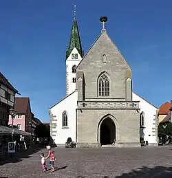 Saint John the Baptist Church | |
 Coat of arms | |
Location of Bad Saulgau within Sigmaringen district 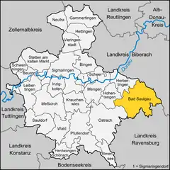 | |
 Bad Saulgau 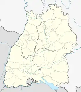 Bad Saulgau | |
| Coordinates: 48°1′3″N 9°30′1″E | |
| Country | Germany |
| State | Baden-Württemberg |
| Admin. region | Tübingen |
| District | Sigmaringen |
| Subdivisions | 14 |
| Government | |
| • Mayor (2015–23) | Doris Schröter[1] |
| Area | |
| • Total | 97.34 km2 (37.58 sq mi) |
| Elevation | 587 m (1,926 ft) |
| Population (2021-12-31)[2] | |
| • Total | 17,586 |
| • Density | 180/km2 (470/sq mi) |
| Time zone | UTC+01:00 (CET) |
| • Summer (DST) | UTC+02:00 (CEST) |
| Postal codes | 88348 |
| Dialling codes | 07581 |
| Vehicle registration | SIG or SLG[3] |
| Website | www.bad-saulgau.de |
Geography
Bad Saulgau is located north of the wooded hills Wagenhart and a few kilometers west-northwest of the hill Atzenberger Höhe. It is located between the Danube and Lake Constance, on the Danube tributary Schwarzach. The European watershed, which separates the catchment areas of the Rhine and the Danube, runs through the municipal district Lampertsweiler. The waters flowing southward eventually join the Rhine, the northbound ones the Danube.
Neighboring communities
Bad Saulgau borders the following municipalities, clockwise starting from the North: Ertingen, Riedlingen, Allmannsweiler, Bad Buchau, Dürnau, Bad Schussenried, Ebersbach-Musbach, Boms, Eichstegen, Hoßkirch, Ostrach, Hohentengen and Herbertingen.
Subdivisions
Bad Saulgau consists of the main town (with Bernhausen, Enge Weiler, Schwarzach and Wilfertsweiler) and 13 Ortsteile.
| Coat of arms | District | Inhabitants | Area |
|---|---|---|---|
| Bad Saulgau (main locality) | 11,673 | 5690 ha | |
| Bierstetten and Steinbronnen | 591 | 615 ha | |
| Bolstern and Heratskirch | 417 | 1206 ha | |
| Bondorf | 333 | 278 ha | |
| Braunenweiler/Untereggartsweiler | 553 | 1005 ha | |
| Friedberg | 406 | 541 ha | |
| Fulgenstadt | 672 | 673 ha | |
| Großtissen and Kleintissen | 374 | 669 ha | |
| Haid-Sießen-Bogenweiler | 874 | 1320 ha | |
| Hochberg and Luditsweiler | 579 | 664 ha | |
| Lampertsweiler | 302 | 252 ha | |
| Moosheim | 337 | 443 ha | |
| Renhardsweiler | 273 | 170 ha | |
| Wolfartsweiler | 275 | 351 ha |
History
The first historical reference to the settlement dates back to 819. In 1239, it received town privileges from Frederick II, Holy Roman Emperor. The town became a possession of the House of Habsburg in 1299, and thus part of Further Austria. In Napoleonic times, it was incorporated into the Kingdom of Württemberg.
During World War II, a subcamp of the Dachau concentration camp was located in the town.[4] In 2005, a memorial commemorating the camp and the victims was inaugurated at the camp's former location.[5]
After World War II, Saulgau was part of the French occupation zone in 1945 and became part of the newly founded state of Württemberg-Hohenzollern in 1947, which was incorporated into the state of Baden-Württemberg in 1952.
In 2000, the name of the town was officially changed from Saulgau to Bad Saulgau, where the German Bad refers to its spa facilities and important natural thermal source.
Education
Apart from nursery schools, Bad Saulgau has several public schools from primary to secondary level, for vocational training as well as a centre for secondary schools specialised in economics or technical training. (Technisches Gymnasium, Wirtschaftsgymnasium)
The Toin Gakuen Schule Deutschland, a Japanese international boarding secondary school, was previously located in Bad Saulgau, but closed in 2012.[6]
Notable people
- Sebastian Rentz (born 1799), winemaker
- Franz Michelberger (born 1955), football player
- Erik E. Lehmann (born 1963), economist
- Stefan Buck (born 1980), football player
- Fabian Gerster (born 1986), football player
- Tatjana Maria born Malek (born 1987), tennis player
- Isabelle Harle (born 1988), swimmer and multiple German champion, world and European champion
Notes
- Aktuelle Wahlergebnisse, Staatsanzeiger, accessed 15 September 2021.
- "Bevölkerung nach Nationalität und Geschlecht am 31. Dezember 2021" [Population by nationality and sex as of December 31, 2021] (CSV) (in German). Statistisches Landesamt Baden-Württemberg. June 2022.
- "Kreistag stimmt für SLG-Kennzeichen". Schwäbische. 27 July 2020.
- Gedenkstätten für die Opfer des Nationalsozialismus. Eine Dokumentation. volume I. Bonn 1995, ISBN 3-89331-208-0, p. 74 (in German)
- Jürgen Witt: Gedenken an Opfer der NS-Tyrannei. Nazi-Verfolgung in der Region. In: Südkurier vom 29. Januar 2015 (in German)
- "Japanische Schule kehrt Bad Saulgau den Rücken" (Archive). Südkurier. 20 March 2010. Retrieved on 6 January 2015.
Towns and municipalities in Sigmaringen (district) | ||
|---|---|---|