Sedalia, Colorado
Sedalia is an unincorporated town, a post office, and a census-designated place (CDP) located in and governed by Douglas County, Colorado, United States. The CDP is a part of the Denver–Aurora–Lakewood, CO Metropolitan Statistical Area. The Sedalia post office has the ZIP Code 80135.[4] At the United States Census 2020, the population of the Sedalia CDP was 177.[3]
Sedalia, Colorado | |
|---|---|
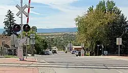 Looking south on Manhart Street in Sedalia. | |
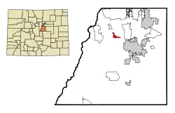 Location of the Sedalia CDP in Douglas County, Colorado. | |
 Sedalia Location of the Sedalia CDP in the United States. | |
| Coordinates: 39°26′23″N 104°58′12″W[1] | |
| Country | |
| State | |
| County | Douglas County |
| Government | |
| • Type | unincorporated town |
| Area | |
| • Total | 1.363 sq mi (3.531 km2) |
| • Land | 1.363 sq mi (3.531 km2) |
| • Water | 0.000 sq mi (0.000 km2) |
| Elevation | 5,823 ft (1,775 m) |
| Population | |
| • Total | 177 |
| • Density | 130/sq mi (50/km2) |
| Time zone | UTC-7 (MST) |
| • Summer (DST) | UTC-6 (MDT) |
| ZIP Code[4] | 80135 |
| Area codes | 303 & 720 |
| GNIS feature[2] | Sedalia CDP |
History
The Sedalia post office has been in operation since 1872.[5] The community was named after Sedalia, Missouri.[6]
Geography
Sedalia is located in northern Douglas County along U.S. Route 85, which leads 8 miles (13 km) southeast to Castle Rock, the county seat, and north 24 miles (39 km) to downtown Denver.
The Sedalia CDP has an area of 873 acres (3.531 km2), all land.[1]
Demographics
The United States Census Bureau initially defined the Sedalia CDP CDP for the United States Census 2000.
| Year | Pop. | ±% |
|---|---|---|
| 2000 | 211 | — |
| 2010 | 206 | −2.4% |
| 2020 | 177 | −14.1% |
| Source: United States Census Bureau | ||
Education
The Douglas County School District serves Sedalia.
Notable residents
- Philip F. Roach (1881-1976), U.S. Coast Guard Commodore, Navy Cross recipient,[7]
See also
References
- "State of Colorado Census Designated Places - BAS20 - Data as of January 1, 2020". United States Census Bureau. Retrieved December 21, 2020.
- "U.S. Board on Geographic Names: Domestic Names". United States Geological Survey. Retrieved December 21, 2020.
- United States Census Bureau. "Sedalia CDP, Colorado". Retrieved April 17, 2023.
- "Look Up a ZIP Code". United States Postal Service. Retrieved December 21, 2020.
- "Post offices". Jim Forte Postal History. Retrieved July 9, 2016.
- Dawson, John Frank. Place names in Colorado: why 700 communities were so named, 150 of Spanish or Indian origin. Denver, CO: The J. Frank Dawson Publishing Co. p. 46.
- "Philip Francis Roach". Hall of Valor. Military Times. Retrieved April 20, 2016.
External links
Municipalities and communities of Douglas County, Colorado, United States | ||
|---|---|---|
| Cities |  Map of Colorado highlighting Douglas County | |
| Towns | ||
| CDPs | ||
| Unincorporated communities | ||
| Ghost towns | ||
| Footnotes | ‡This populated place also has portions in an adjacent county or counties | |