Selirong Island
Selirong Island (Malay: Pulau Selirong), also known as Mosquito Island,[2] is an island located within the Brunei Bay and Mukim Labu, Temburong District, Brunei.[3] The island also sits at the river delta of the Temburong River.[4]
Native name: Pulau Selirong Nickname: Mosquito Island | |
|---|---|
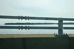
 Selirong Island as seen from Sultan Haji Omar Ali Saifuddien Bridge | |
 Selirong Island Location in Brunei | |
| Geography | |
| Location | Brunei Bay |
| Coordinates | 4.8818999°N 115.1298164°E |
| Area | 25[1] km2 (9.7 sq mi) |
| Highest elevation | 1 m (3 ft) |
| Administration | |
| District | Temburong |
| Mukim | Labu |
| Demographics | |
| Population | 0 |
History
In 1948, the 2,499 hectares (6,180 acres) Labu–Selirong Wildlife Sanctuary was established.[5] Initially in 1950, plans for both the Andulau and Selirong Forest Reserve were set to begin within that year but later fell through.[6] Later in 1954, the Labu–Selirong Wildlife Sanctuary was later expanded to an area of 8,984 hectares (22,200 acres).[5]
Tourism
It is home to the Selirong Island Mangrove Park and Selirong Forest Reserve.[7][8] The island consisted of the largest mangrove swamps and wildlife reserve with an area of 2,566 hectares (6,340 acres).[9][10] Selirong is one of the ten islands used for ecotourism, research and educational purposes.[11] In order to monitor and investigate the wildlife on the island, notably a 2 kilometres (1.2 mi) walkway and an observation tower were built.[12]
Flora
Animals such as the proboscis monkeys, macaques, kingfishers and eagles made up the fauna.[13]
Fauna
Plants such as the nipah palms, stilt roots, bakau trees can be found in the Pulau Selirong Forest Recreation Park.[14]
Transportation
The island can only be accessed by speedboats from Bandar Seri Begawan.[15] The estimated time to reach the island from Muara is 45 minutes as it is required to pass through the Brunei River and across the Brunei Bay.[16]
See also
References
- "Pulau Selirong Recreational Park | Brunei Darussalam Attractions". Lonely Planet. Retrieved 2022-07-08.
- Borneo Bulletin Brunei Yearbook. Brunei Press Sdn. Bhd. in collaboration with Integrated Information Pte. Limited. 2007.
- The Asian Wetlands: Bringing Partnerships Into Good Wetland Practices : Proceedings of the Asian Wetland Symposium 2001 "bringing Partnerships Into Good Wetland Practices", 27-30 August 2001, Penang, Malaysia. Penerbit Universiti Sains Malaysia. 2002. p. 293.
- "Brunei Darussalam: Nature-Based Tourism". Southeast Asia Travel. Retrieved 2022-07-08.
- Nature, World Wide Fund for (1989). A Directory of Asian Wetlands. IUCN, The World Conservation Union. p. 915. ISBN 978-2-88032-984-6.
- Office, Great Britain Colonial (1950). Annual Report on Brunei for the Year. H.M. Stationery Office. p. 22.
- The Report: Brunei Darussalam 2009. Oxford Business Group. 2009. p. 136. ISBN 978-1-907065-09-5.
- Silvestre, Geronimo (1992). The Coastal Resources of Brunei Darussalam: Status, Utilization and Management. WorldFish. p. 149. ISBN 978-971-8709-11-5.
- Forum, IUCN World Commission on Protected Areas Southeast Asia Regional (2000). The World Commission on Protected Areas, 2nd Southeast Asia Regional Forum, Pakse, Lao PDR, 6-11 December 1999: Papers presented. IUCN Lao PDR. p. 56.
- "SELIRONG ISLAND MANGROVE TOUR". Borneo Tour Specialists.
- The Integrated Management Plan for the Coastal Zone of Brunei Darussalam. WorldFish. 1992-01-01. p. 86. ISBN 978-971-8709-15-3.
- Asia, Inc: The Region's Business Magazine. Manager International Company. 2002. p. 19.
- Fidgeon, Tamsin (2004). World Travel Guide. Highbury Columbus Travel Publishing. p. 105. ISBN 978-1-902221-84-7.
- "Department of Fisheries - Pulau Selirong Forest Recreation Park". www.fisheries.gov.bn. Retrieved 2022-07-08.
- Welcome to Brunei Darussalam: The Complete Traveller's Guide. Brunei Press. 2000. p. 39. ISBN 978-99917-32-05-3.
- Fidgeon, Tamsin (2004). World Travel Guide. Highbury Columbus Travel Publishing. p. 105. ISBN 978-1-902221-84-7.