Seljord (village)
Seljord is the administrative centre of Seljord Municipality in Vestfold og Telemark county, Norway. The village is located along the European route E134 highway, on the north end of the lake Seljordsvatn. It is located about 12 kilometres (7.5 mi) to the northeast of Kviteseidbyen, about 12 kilometres (7.5 mi) south of Flatdal, and about 25 kilometres (16 mi) southeast of Åmotsdal.[3]
Seljord | |
|---|---|
Village | |
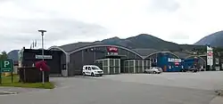 View of the village business district | |
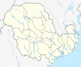 Seljord Location of the village  Seljord Seljord (Norway) | |
| Coordinates: 59.48477°N 8.63017°E | |
| Country | Norway |
| Region | Eastern Norway |
| County | Vestfold og Telemark |
| District | Vest-Telemark |
| Municipality | Seljord Municipality |
| Area | |
| • Total | 2.21 km2 (0.85 sq mi) |
| Elevation | 126 m (413 ft) |
| Population (2022)[1] | |
| • Total | 1,415 |
| • Density | 641/km2 (1,660/sq mi) |
| Time zone | UTC+01:00 (CET) |
| • Summer (DST) | UTC+02:00 (CEST) |
| Post Code | 3840 Seljord |
The 2.21-square-kilometre (550-acre) village has a population (2022) of 1,415 and a population density of 641 inhabitants per square kilometre (1,660/sq mi).[1]
The Mælefjell Tunnel is located just a short distance north of the village. Seljord Church is also located in the village. The village is also the site of the Seljord folk high school, one of three of these schools in Telemark.[3]
References
- Statistisk sentralbyrå (1 January 2022). "Urban settlements. Population and area, by municipality".
- "Seljord, Seljord". yr.no. Retrieved 13 August 2023.
- Mæhlum, Lars, ed. (28 December 2022). "Seljord (tettstad)". Store norske leksikon (in Norwegian). Kunnskapsforlaget. Retrieved 13 August 2023.