Semyonov Peak
Semyonov Peak (Russian: Пик Семёнова, romanized: Pik Semyonova, Kyrgyz: Семёнов чокусу, romanized: Semyonov chokusu) is a 5,816-metre (19,081 ft) high mountain in the Tian Shan on the border between Kyrgyzstan and Kazakhstan.[2][3]
| Semyonov Peak | |
|---|---|
| Pik Semyonova | |
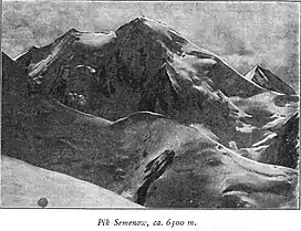 Taken by German geographer Gottfried Merzbacher in 1902/3 | |
| Highest point | |
| Elevation | 5,816 m (19,081 ft)[1] |
| Prominence | 802 m (2,631 ft)[1] |
| Coordinates | 42°16′34″N 80°7′5″E |
| Geography | |
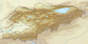 Semyonov Peak  Semyonov Peak Semyonov Peak (Kazakhstan) | |
| Parent range | Saryjaz Range, Tian Shan |
Semyonov Peak is one of the highest peaks of the Saryjaz Range. To its northwest lies the Semyonov Glacier.[2] It lies 8.64 km northwest of Khan Tengri (6995 m) on the opposite side of the Northern Engilchek Glacier. The peak is named after the Russian geographer Pyotr Semyonov-Tyan-Shansky.[2]
References
- "Semionova". Peakbagger.com. Retrieved 2020-11-20.
- "Семёнов чокусу" [Semyonov Peak] (PDF). Кыргызстандын Географиясы [Geography of Kyrgyzstan] (in Kyrgyz). Bishkek. 2004. p. 83.
{{cite encyclopedia}}: CS1 maint: location missing publisher (link) - "Pik Semenova". peakvisor.com. Retrieved 2020-11-20.
This article is issued from Wikipedia. The text is licensed under Creative Commons - Attribution - Sharealike. Additional terms may apply for the media files.