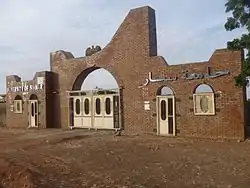
Sennar
Sennar (Arabic: سنار Sannār) is a city on the Blue Nile in Sudan and possibly the capital of the state of Sennar.[1] It remains publicly unclear whether Sennar or Singa is the capital of Sennar State. For several centuries it was the capital of the Funj Kingdom of Sennar.
Sennar
سنار | |
|---|---|
 | |
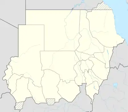 Sennar Location in Sudan | |
| Coordinates: 13°33′N 33°35′E | |
| Country | |
| State | Sinnar State |
| Population (2007) | |
| • Total | 143,059 |
Overview
The French traveler Charles-Jacques Poncet, who visited Sennar near the end of the 17th century, estimated the town had a population of 100,000 inhabitants. However, when the Dutch explorer Juan Maria Schuver travelled through the town in April 1881, he doubted it had "anything like 100,000 inhabitants, when Khartoum, the centre and capital of a tenfold larger country is not able to muster more than a quarter of that number, if we exclude the garrison."[2] He observed that Sennar had declined as trade had over the years shifted to Karkoj, "much more advantageously situated as the terminus of regular navigation, as the natural outlet of the Takruri country between Kassala and Galabat."[2]
The modern town lies SSE of the ruins of the ancient capital of the Funj Kingdom, 300 kilometres (186 miles) southeast of Khartoum, the Capital of Sudan.
The city is home to Sinnar University, established in 1977.[3]
Climate
Despite receiving over 400 millimetres or 16 inches of rainfall per year, the extreme heat and high evaporation means Sennar still has a borderline hot arid climate (Köppen BWh) a little below a hot semi-arid climate (BSh).
| Climate data for Sennar (1961-1990, extremes 1907-present) | |||||||||||||
|---|---|---|---|---|---|---|---|---|---|---|---|---|---|
| Month | Jan | Feb | Mar | Apr | May | Jun | Jul | Aug | Sep | Oct | Nov | Dec | Year |
| Record high °C (°F) | 44.0 (111.2) |
45.9 (114.6) |
45.4 (113.7) |
47.0 (116.6) |
46.4 (115.5) |
46.5 (115.7) |
42.7 (108.9) |
41.5 (106.7) |
41.3 (106.3) |
42.0 (107.6) |
41.5 (106.7) |
40.3 (104.5) |
47.0 (116.6) |
| Average high °C (°F) | 33.5 (92.3) |
35.5 (95.9) |
38.9 (102.0) |
41.3 (106.3) |
41.1 (106.0) |
38.7 (101.7) |
35.2 (95.4) |
33.9 (93.0) |
35.3 (95.5) |
37.5 (99.5) |
36.4 (97.5) |
34.1 (93.4) |
36.8 (98.2) |
| Daily mean °C (°F) | 23.7 (74.7) |
25.5 (77.9) |
28.9 (84.0) |
31.3 (88.3) |
32.8 (91.0) |
31.5 (88.7) |
28.9 (84.0) |
28.0 (82.4) |
28.6 (83.5) |
29.9 (85.8) |
27.5 (81.5) |
28.6 (83.5) |
28.8 (83.8) |
| Average low °C (°F) | 14.0 (57.2) |
15.4 (59.7) |
19.0 (66.2) |
21.4 (70.5) |
21.5 (70.7) |
24.2 (75.6) |
22.7 (72.9) |
22.1 (71.8) |
21.9 (71.4) |
22.2 (72.0) |
18.6 (65.5) |
15.2 (59.4) |
19.9 (67.8) |
| Record low °C (°F) | 5.4 (41.7) |
5.7 (42.3) |
8.7 (47.7) |
10.0 (50.0) |
15.0 (59.0) |
16.7 (62.1) |
17.0 (62.6) |
17.6 (63.7) |
17.0 (62.6) |
14.7 (58.5) |
8.0 (46.4) |
4.7 (40.5) |
4.7 (40.5) |
| Average rainfall mm (inches) | 0.0 (0.0) |
0.0 (0.0) |
0.0 (0.0) |
0.0 (0.0) |
20.5 (0.81) |
66.1 (2.60) |
99.2 (3.91) |
135.9 (5.35) |
84.5 (3.33) |
13.7 (0.54) |
0.2 (0.01) |
0.0 (0.0) |
420.1 (16.55) |
| Average rainy days (≥ 0.1 mm) | 0.0 | 0.0 | 0.0 | 0.0 | 3.2 | 5.7 | 9.0 | 9.6 | 6.3 | 2.6 | 0.0 | 0.0 | 36.4 |
| Average relative humidity (%) | 34 | 28 | 23 | 21 | 30 | 44 | 58 | 64 | 60 | 48 | 34 | 36 | 40 |
| Mean monthly sunshine hours | 319.3 | 285.6 | 306.9 | 303.0 | 294.5 | 249.0 | 217.0 | 226.3 | 249.0 | 285.2 | 309.0 | 313.1 | 3,357.9 |
| Percent possible sunshine | 91 | 87 | 82 | 81 | 76 | 66 | 54 | 59 | 69 | 78 | 91 | 90 | 77 |
| Source 1: NOAA[4] | |||||||||||||
| Source 2: Meteo Climat (record highs and lows)[5] | |||||||||||||
Demographics
| Year | Population |
|---|---|
| 1973 (Census) | 28,546 |
| 1983 (Census) | 42,803 |
| 1993 (Census) | 72,187 |
| 2007 (Estimate) | 143,059 |
Notable people
- Nasra bint ʿAdlan, Sudanese royalty
See also
References
- "Sudan tribune news site".
- Wendy James, Gerd Baumann, and Douglas H. Johnson, Juan Maria Schuver's Travels in North East Africa, 1880-1883 (London: Hakluyt Society, 1996), p. 13
- "Sinar University". African Studies Center. Archived from the original on 2011-08-12. Retrieved 2011-09-17.
- "Sennar Climate Normals 1961-1990". National Oceanic and Atmospheric Administration. Retrieved 22 October 2016.
- "Station Sennar" (in French). Meteo Climat. Retrieved 22 October 2016.
External links
![]() Media related to Sennar (town) at Wikimedia Commons
Media related to Sennar (town) at Wikimedia Commons