North Hills, Los Angeles
North Hills, known previously as Sepulveda, is a neighborhood in the San Fernando Valley region of Los Angeles, California.
North Hills
Sepulveda | |
|---|---|
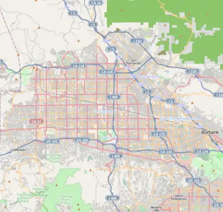 North Hills Location within Los Angeles/San Fernando Valley 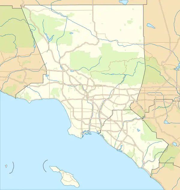 North Hills North Hills (the Los Angeles metropolitan area) | |
| Coordinates: 34°14′08″N 118°29′06″W | |
| Country | |
| State | |
| County | Los Angeles |
| City | Los Angeles |
| City Council Districts | • District 6 • District 7 • District 12 |
| Neighborhood Councils | • North Hills East • North Hills West |
| Named for | Location in the north of Los Angeles |
| Elevation | 256 m (841 ft) |
| Population (2000)[1] | |
| • Total | 56,946 |
| Time zone | UTC-8 (PST) |
| • Summer (DST) | UTC-7 (PDT) |
| ZIP code | 91343 |
| Area code(s) | 818 and 747 |
North Hills was originally part of an agricultural community known as Mission Acres. After WWII, the newly developed suburban community was renamed Sepulveda, after the prominent Sepúlveda family of California. In 1991, it was renamed North Hills.
Geography
North Hills is located in the central San Fernando Valley region of the City of Los Angeles, 21 miles northwest of downtown.[2] North Hills is bounded by Balboa Boulevard and Bull Creek ("the wash") on the west, Devonshire and Lassen Street on the north, the Pacoima Wash on the east, and Roscoe Boulevard on the south.
Surrounding neighborhoods are Northridge to the west, Panorama City to the east, Van Nuys to the south, and Granada Hills to the north. The neighborhood is divided into North Hills West and North Hills East by California Interstate 405, known locally as "the 405".
Overlapping Area codes 747 and 818 serve the area. The North Hills ZIP code is 91343.
History

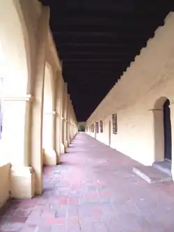
In the late 18th and 19th century the site was part of the Mission San Fernando Rey de España lands, until 1846 when it became part of the Rancho Ex-Mission San Fernando of Andrés Pico, near the Andrés Pico Adobe.
Rancho land
The Mexican armed resistance to the American intervention ceased in the beginning of 1848 and the Treaty of Guadalupe Hidalgo ceded the California Territory to the United States. The Treaty provided that the Mexican land grants would be honored and American officials acquired Spanish and Mexican records to confirm titles.[3] The rancho land grant was patented to Eulogio de Celis in 1873.[4] De Celis sold the southern half of the rancho, south of what is roughly now Roscoe Boulevard to Andrés Pico in 1854; Pico had sold his half-interest in the rancho to his brother Pío Pico in 1862, retaining 2,000 acres (8 km2) called the Pico Reserve around the old Mission. In a 1871 plat of the rancho, the North Hills area is shown to be relatively undeveloped land just south of the Pico Reserve with a road from the Mission to the Rancho Los Encino crossing the land diagonally and a sheep camp located just north of the ranch partition line to the west of the Pacoima Wash.[5] De Celis died in 1869 and his son Eulogio F. de Celis sold the northern half, which includes what is now North Hills, to Charles Maclay, George K. Porter and Benjamin F. Porter in 1875.[6]
Porter land
The Porter cousins' land lied to the west of present-day Sepulveda Boulevard and the Maclay land lied to the east.[7] In 1881, the Porter cousins split their holdings and George received the portion between Sepulveda Boulevard and Aliso Canyon. In 1882, the Porters received one-third of the Maclay land; with this purchase, the Porter's land covered all of current North Hills land. In 1887, George K. Porter subdivided the land and established the Porter Land and Water Company to take advantage of a land sales boom.[8] John B. Baskin, a partner and sales agent of the company began an extensive marketing and promotional campaign for the land subdivision; a frequent motif of the marketing is the remains of the mission which was surrounded by the tract. Baskin also hired California State Engineer William Hammond Hall to develop an irrigation plan for water derived from the local springs and arroyos like the current Pacoima Wash. The boom began to fade by the end of 1888 and went bust the next year with internal company problems and declining national and local economies which preceded the Panic of 1893; the decline would also be excacerbated by severe droughts in the 1890s. In October of 1903, Porter sold his firm and transferred remaining lands to a syndicate led by Leslie C. Brand which was incorporated as the San Fernando Mission Land Company in 1904.[9][10][11]
Community development
Mission Acres was an agricultural community made by early developers who created 1 acre plots for agricultural activities, with irrigation supplied by the Los Angeles Aqueduct in 1913.[12] The community was a stop for the Pacific Electric railway streetcars that transported passengers from downtown Los Angeles to the San Fernando Valley.[13]
Residents of Mission Acres renamed the area Sepulveda in 1927.[2][13] The Californio Sepulveda family, going back to the founding of the Pueblo of Los Angeles,[14] is the source of various Los Angeles place-names, including the post-war community of Sepulveda. Sepulveda Boulevard is the primary north–south street through North Hills, crossing Sepulveda Pass to the south. The community saw significant growth between the 1930s and the 1950s.[2]
In 1937, councilman Jim Wilson offered a resolution that instructed the city's real estate agent to make the right of way cost appraisal for diverting flood waters from Wilson and East Canyons into Pacoima Wash to protect the community of Sepulveda from floods that occurred during heavy storms.[15]
The area remained mostly rural through the 1940s, urbanization initiated during the 1950s during which the entire San Fernando Valley was experiencing a transition from semi-rural and agricultural uses into suburban development patterns. Multi-family residential units began to be developed in the 1960s.[16]
In 1991, residents of the western half of Sepulveda, west of the San Diego Freeway, voted to secede from the eastern section to form a new community named North Hills. The City of Los Angeles soon changed the name of remaining Sepulveda to North Hills also.[17] The city then formed a new sub-neighborhood of "North Hills West" which begins west of the 405 freeway and goes to Bull Creek Wash/Balboa Blvd. and from Roscoe Blvd. to Devonshire St.[18][19] The eastern section became the sub-neighborhood of North Hills East.[20]
North Hills East boundaries are east of the 405-San Diego Freeway, along the Pacoima Wash, South of Lassen, and North of Roscoe.[21]
In June 1999, a damaged airplane landed safely on Hayvenhurst Avenue on its way to Van Nuys Airport.[13]
As of 2020, about 242 (1.3%) of the approximately 17,977 occupied structures in North Hills were built in 1939 or earlier, 34.9% were built from 1940 to 1959, 3.4% from 1960 to 1979, 5.2% from 2000 to 2009, 0.9% from 2010 to 2013, and 1% from 2014 or later.[22]
Government
Local government
North Hills is governed locally by the City of Los Angeles and is represented in the Los Angeles City Council by the members elected for districts 6, 7 and 12; each district includes three different sections of the neighborhood.[23]
| Council District | Council Member | Neighborhood area served |
|---|---|---|
| City Council District 6 | Imelda Padilla | South portion of North Hills East |
| City Council District 7 | Monica Rodriguez | North portion of North Hills East |
| City Council District 12 | John Lee | North Hills West |
Neighborhood Councils
Both North Hills East and North Hills West Neighborhood Councils work together to improve the overall quality of life in North Hills communities.
North Hills West Neighborhood Council was certified in 2003.[24] Their slogan is "Fostering Community," and its logo is of a green tree in the city.[24] The 2012-2014 North Hills West Neighborhood Council was seated into office on September 20, 2012.[25] A northwestern section became part of the Northridge East Neighborhood Council in 2013.[26]
North Hills East Neighborhood Council was certified in 2010.[27] It has a growing, multicultural group of neighbors dedicated to service and community activism. In early 2014, North Hills East Neighborhood Council was approved as an Official Certifying Organization for the President's Volunteer Service Awards program, which is an initiative of the Corporation for National and Community Service, the same organization responsible for AmeriCorps and Senior Corps. This status as an Official Certifying Organization has enabled the North Hills East Neighborhood Council to verify hours and eligibility for volunteers to receive an award, which, depending on number of hours worked can range from a pin to a personalized letter from the President of the United States. More about the awards can be found here: www.presidentialserviceawards.gov Volunteers do not have to be a resident or stakeholder of North Hills East to qualify for a President's Volunteer Service Award.
Federal and State legislature representation
The neighborhood is represented federally by the congress member elected for California's 29th congressional district and both senators from California. On the state level, it is represented by the state assembly member elected for California State Assembly District 46 and the state senator elected for California State Senate District 18.
| United States Congress |
|---|
| United States Senate |
| California State Assembly |
|---|
| California State Senate |
Demographics
In 2009, the Los Angeles Times's "Mapping L.A." project supplied these North Hills community statistics: median household income: $52,456.[28] Population size is 60,254 according to 2010 Census data. This summarizes both sides of the 405 freeway. The North Hills West neighborhood had 24,000 residents in 2009.[19] The North Hills East neighborhood had nearly 40,000 residents in 2010.[21]
Education
Public schools
The community is served by schools in the Los Angeles Unified School District.[29]
Gledhill Street Elementary School, Langdon Avenue Elementary School, Mayall Street School, and Parthenia Street School serve North Hills.[30]
Most students attend Sepulveda Middle School.[31] Those students residing west of Woodley Avenue attend Holmes Middle School.[32]
North Hills high school students attend James Monroe High School.[33]
There are magnet programs in some schools, such as the Sepulveda Middle School which has a Gifted / High Ability Magnet, and Kennedy High School which has an Architecture/Digital Arts Magnet. A school bus is provided if pupils are more than 5 miles away from the school. North Hills West is also served by charter schools of all grades.
| Name | Grades |
|---|---|
| Mayall Street Elementary | K-5 |
| Vintage Math/Science/Technology Magnet | K-5 |
| Lassen Elementary | K-5 |
| Francisco Sepulveda Middle | 6-8 |
| Gledhill Street Elementary | K-5 |
| Albert Einstein Continuation | 9-12 |
| Valley Region Elementary No. 12 | K-5 |
| Plummer Elementary | K-5 |
| James Monroe High | 9-12 |
| Valley Charter Elementary | K-5 |
| Our Community Charter | K-8 |
| Rosa Parks Learning Center | K-5 |
| Langdon Avenue Elementary | K-5 |
| Noble Avenue Elementary | K-5 |
| Vista Middle | 6-8 |
Local School District Administration
| Local District | Superintendent | Neighborhood area served |
|---|---|---|
| Local District Northwest | David Baca | Most of North Hills |
| Local District Northeast | Andrés Chait | Small portion south of North Hills East |
| District | Board Member | Neighborhood area served |
|---|---|---|
| 3 | Scott Schmerelson[38] | Most of North Hills West |
| 6 | Kelly Gonez[39] | Most of North Hills East and small portion of West |
Private schools
The private and parochial schools in North Hills include Valley Park Baptist, Valley Presbyterian School, Heritage Christian, Our Lady of Peace, and Church of the Living Word. Los Angeles Baptist High School also serves the community and in 2012, was combined with Heritage Christian High School.
Several North Hills residents serve as host families to international students studying in the US. As of early 2014, about 50 foreign exchange students are attending school in the North Hills area. Host families get to share their way of life and culture with the students, and at the same time learn more about the students and their home countries.
| Name | Grades |
|---|---|
| Los Angeles Baptist Middle School/High School | 6-12 |
| North Hills Prep | 7-12 |
| Valley Presbyterian Elementary | K-6 |
| Our Lady of Peace Elementary | K-8 |
| Centers of Learning | K-12 |
| New Generation | K-6 |
| Holy Martyrs Armenian Elementary | K-5 |
| Valley High School/Site 1 | 6-12 |
| Valley High School/Site 2 | 6-12 |
Public library
The Los Angeles Public Library Mid-Valley Regional Branch, one of the biggest in the San Fernando Valley, is located on Nordhoff Street at Woodley Avenue in North Hills.[41]
Infrastructure
California Interstate 405 has direct access to the neighborhood on two points: exit 68 on Roscoe Boulevard and exit 69 on Nordhoff Street.[42] Main thoroughfares include Sepulveda and Roscoe Boulevards; Hayvenhurst, Woodley, and Haskell Avenues; Lassen, Plummer, and Nordhoff Streets. These thoroughfares, as is the case in the most of the San Fernando Valley. are arranged in a grid pattern with north–south ways labeled as avenues and east–west ways labeled as streets.
Bicycle infrastructure in the neighborhood includes marked street-side bike lanes on Devonshire Street, on Nordhoff Street starting eastward from Orion Avenue, Parthenia Street eastward from Burnet Avenue, and south–north lanes on Woodley Avenue. Plummer Street is designated as a bike route, allowing cyclists to share space with other vehicular traffic.[43][44]
The Los Angeles County Metropolitan Transportation Authority operates Metro Bus local lines 152,[45] 166,[46] 167,[47] 234,[48] and 237[49] through the neighborhood and the Los Angeles Department of Transportation's Panorama City/Van Nuys DASH route also runs through part of the neighborhood.[50]
North Hills is home to the large Veterans Administration Sepulveda Ambulatory Care Center campus, which serves veterans in the San Fernando Valley, with residential and outpatient care.[51][52]
Films
There are many locations in North Hills that have been used for various films such as "Terminator 2: Judgement Day", "Halloween (2007 film)", "Halloween II (2009 film)", "American Beauty (1999 film)", and "Step Brothers (film)".
Many of the films were shot in the Sepulveda VA Clinic to shoot large shots to captivate wide scenes, such as in the movie Step Brothers, the area is used to show a large fight between two men and a large group of kids. In one of the most famous scenes in the film Terminator 2: Judgement Day, after thinking John the main protagonist finally escaped the T-1000, due to some help from the T-800, John is surprised when the T-1000 drives a semi truck through the overpass wall of Bull Creek, a flood control channel located in North Hills.[53]
Notable people
- Bart Andrus, professional football coach and former collegiate player
- Kerry Rossall, stuntman and actor
- Sharon Shapiro, gymnast
References
- "Los Angeles Almanac: City of Los Angeles Population by Community & Race 2000 Census". Archived from the original on January 11, 2010. Retrieved April 4, 2010.
- Pitt, Leonard; Pitt, Dale (1997). Los Angeles A to Z. Los Angeles, California: University of California Press. p. 360. ISBN 978-0-520-20274-0.
- Beck, Warren A. and Ynez D. Haase, Historical Atlas of California, first edition, p.24
- Report of the Surveyor General 1844 - 1886 Archived 2013-03-20 at the Wayback Machine
- "Plat of the Ex Mission de San Fernando finally confirmed to Eulogio de Celis". hdl.huntington.org. Retrieved 2023-06-08.
- "In 1800s, De Celis Owned Most of the Valley", L.A. Times, July 9, 1997.
- K. Roderick, 2001, The San Fernando Valley: America’s Suburb, Los Angeles Times, Los Angeles, California, ISBN 978-1-883792-55-8
- Hodges, Hugh T. (1986). "Charles Maclay: California Missionary, San Fernando Valley Pioneer: PART III". Southern California Quarterly. 68 (4): 329–363. doi:10.2307/41171239. ISSN 0038-3929. JSTOR 41171239.
- "Water and Power Associates". waterandpower.org. Retrieved 2023-06-08.
- "Porter Land and Water Company". The Lopez Adobe. Retrieved 2023-06-08.
- Hoffman, Abraham (1981). Vision or Villainy: Origins of the Owens Valley–Los Angeles Water Controversy. Texas A&M University Press. ISBN 0-89096-509-9.
- "Community Profile / North Hills". LA Times. February 23, 1997. Retrieved 23 July 2016.
- Hoffmann, Michelle (2004-02-01). "Treasures amid Valley bustle". Los Angeles Times. Retrieved 2020-08-17.
- Wittenburg, Mary Joanne (1991). "Three Generations of the Sepulveda Family in Southern California". Southern California Quarterly. 73 (3): 197–250. doi:10.2307/41171580. JSTOR 41171580.
- "Daily News (Los Angeles) 17 April 1937 — California Digital Newspaper Collection". cdnc.ucr.edu. Retrieved 2023-01-20.
- "Mission Hills - Panorama City - North Hills Community Plan | Los Angeles City Planning". planning.lacity.org. Retrieved 2023-01-25.
- "What Remains of Sepulveda Will Also Become North Hills : Name change: Residents didn't want to be deserted by their former neighbors. Councilman Wachs says the decision takes effect immediately". 22 November 1991 – via LA Times.
- "Map of North Hills West Neighborhood Council boundaries".
- Neilson 2009
- "Map of North Hills East Neighborhood Council boundaries".
- 2010 Census tracts data.
- "Table S2504: Physical Housing Characteristics for Occupied Housing Units". data.census.gov. 2016-2020 American Community Survey 5-Year Estimates. U.S. Census Bureau. Retrieved October 14, 2022.
- "NavigateLA" (PDF). navigatela.lacity.org. Retrieved 2022-10-14.
- "North Hills West Neighborhood Council: history and information".
- wpadmin. "Home New".
- "Northridge East Neighborhood Council - Making Northridge, CA a Better Place to Live, Work, Play, and Learn - Boundaries".
- "North Hills East Neighborhood Council website".
- "North Hills" entry on the Los Angeles Times "Mapping L.A." website
- "Treasures amid Valley bustle - latimes.com". www.latimes.com. Archived from the original on 28 January 2013. Retrieved 3 February 2022.
- "Gledhill Street Elementary School".
- "Sepulveda Middle School".
- "You are about to leave the LAUSD Network". www.lausd.k12.ca.us.
- "Archived copy". Archived from the original on 2006-01-15. Retrieved 2007-02-06.
{{cite web}}: CS1 maint: archived copy as title (link) - "North Hills". Mapping L.A. Retrieved 2017-01-21.
- "Local Districts Home / Local Districts". achieve.lausd.net. Retrieved 2022-10-14.
- "Board of Education / Board of Education Homepage". achieve.lausd.net. Retrieved 2022-10-14.
- "LAUSD Maps / Board of Education Districts Maps 2022-2023". achieve.lausd.net. Retrieved 2022-10-14.
- "Home". Scott Schmerelson. Retrieved 2022-10-14.
- "Kelly Gonez / Kelly Gonez, Board District 6". achieve.lausd.net. Retrieved 2022-10-14.
- "North Hills". Mapping L.A. Retrieved 2017-01-21.
- "Mid-Valley Regional Library - Los Angeles Public Library". www.lapl.org.
- "Interstate 405 Freeway Interchanges" (PDF). California Numbered Exit Uniform System. California Department of Transportation. March 17, 2020. Retrieved October 22, 2020.
- "City of Los Angeles Bikeways". lahub.maps.arcgis.com. Retrieved 2023-03-01.
- "LA County Bikeways Map". dpw.lacounty.gov. Retrieved 2023-03-01.
- "152 Metro Local Line". LA Metro. Retrieved 2023-01-16.
- "166 Metro Local Line". LA Metro. Retrieved 2023-01-16.
- "167 Metro Local Line". LA Metro. Retrieved 2023-01-16.
- "234 Metro Local Line". LA Metro. Retrieved 2023-01-16.
- "237 Metro Local Line". LA Metro. Retrieved 2023-01-16.
- "DASH Panorama City/Van Nuys | LADOT Transit". www.ladottransit.com. Retrieved 2023-01-16.
- Affairs, VA Greater Los Angeles Healthcare System, U. S. Department of Veterans. "Sepulveda VA Medical Center - VA Greater Los Angeles Healthcare System". www.losangeles.va.gov.
{{cite web}}: CS1 maint: multiple names: authors list (link) - VA Sepulveda Ambulatory Care Center: Medical Campus Map
- "North Hills". Film Oblivion. 15 January 2019. Retrieved 2023-03-13.
External links
North Hills, Los Angeles.
- North Hills West Neighborhood Council
- North Hills East Neighborhood Council
- Los Angeles Times, Real Estate section, Neighborly Advice column: "[North Hills:] Treasures amid Valley bustle" (1 Feb 2004)
| Districts and neighborhoods |
|  |
|---|---|---|
| Points of interest | ||
| Neighboring cities and communities | ||