Sewall's Point, Florida
Sewall's Point is a town located on the peninsula of the same name in Martin County, Florida, United States. The population was 1,991 at the 2020 census.[4] Both the town and the peninsula are named for Capt. Henry Edwin Sewall (August 22, 1848 – August 1, 1925).[5] It is an eastern suburb of Stuart, the Martin county seat.
Sewall's Point, Florida | |
|---|---|
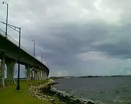 The new Ernest Lyons Bridge, which carries State Road A1A from Hutchinson Island to Sewall's Point | |
 Seal | |
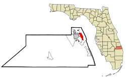 Location in Martin County and the state of Florida | |
| Coordinates: 27°12′N 80°12′W | |
| Country | |
| State | |
| County | Martin |
| Area | |
| • Total | 4.13 sq mi (10.70 km2) |
| • Land | 1.18 sq mi (3.05 km2) |
| • Water | 2.95 sq mi (7.65 km2) |
| Elevation | 20 ft (6 m) |
| Population (2020) | |
| • Total | 1,991 |
| • Density | 1,690.15/sq mi (652.62/km2) |
| Time zone | UTC-5 (Eastern (EST)) |
| • Summer (DST) | UTC-4 (EDT) |
| ZIP code | 34996 |
| Area code | 772 |
| FIPS code | 12-65225[2] |
| GNIS feature ID | 0290880[3] |
| Website | sewallspoint |
Geography
Sewall's Point is located in northeastern Martin County at 27°12′N 80°12′W (27.195, –80.198).[6] Occupying a peninsula, it is bordered by water on the south, east, and west. On the south and west is the St. Lucie River and to the east is the Indian River Lagoon. On the north it is bordered by unincorporated Jensen Beach.
According to the United States Census Bureau, the town has a total area of 4.1 square miles (11 km2), of which 1.2 square miles (3.1 km2) are land and 2.9 square miles (7.5 km2), or 71.48%, are water.[1]
Demographics
| Census | Pop. | Note | %± |
|---|---|---|---|
| 1960 | 151 | — | |
| 1970 | 298 | 97.4% | |
| 1980 | 1,187 | 298.3% | |
| 1990 | 1,588 | 33.8% | |
| 2000 | 1,946 | 22.5% | |
| 2010 | 1,996 | 2.6% | |
| 2020 | 1,991 | −0.3% | |
| U.S. Decennial Census[7] | |||
2020 census
| Race | Number | Percentage |
|---|---|---|
| White (NH) | 1,762 | 88.5% |
| Black or African American (NH) | 15 | 0.75% |
| Native American or Alaska Native (NH) | 3 | 0.15% |
| Asian (NH) | 36 | 1.81% |
| Some Other Race (NH) | 2 | 0.1% |
| Mixed/Multi-Racial (NH) | 55 | 2.76% |
| Hispanic or Latino | 118 | 5.93% |
| Total | 1,991 |
As of the 2020 United States census, there were 1,991 people, 863 households, and 607 families residing in the town.
2010 census
As of the census[2] of 2010, there were 1,999 people, 758 households, and 607 families residing in the town. The population density was 1,578.1 inhabitants per square mile (609.3/km2). There were 828 housing units at an average density of 671.5 per square mile (259.3/km2). The racial makeup of the town was 98.72% White, 0.41% African American, 0.41% Asian, 0.10% from other races, and 0.36% from two or more races. Hispanic or Latino of any race were 1.39% of the population.
There were 758 households, out of which 33.4% had children under the age of 18 living with them, 73.4% were married couples living together, 4.4% had a female householder with no husband present, and 19.8% were non-families. 15.3% of all households were made up of individuals, and 6.5% had someone living alone who was 65 years of age or older. The average household size was 2.57 and the average family size was 2.85.
In the town, the population was spread out, with 24.6% under the age of 18, 2.9% from 18 to 24, 19.9% from 25 to 44, 33.0% from 45 to 64, and 19.7% who were 65 years of age or older. The median age was 47 years. For every 100 females, there were 98.4 males. For every 100 females age 18 and over, there were 96.8 males.
The median income for a household in the town was $97,517, and the median income for a family was $104,893. Males had a median income of $82,748 versus $32,500 for females. The per capita income for the town was $55,121. About 4.6% of families and 4.3% of the population were below the poverty line, including 5.5% of those under age 18 and 3.8% of those age 65 or over.
On September 26, 2004, Hurricane Jeanne made landfall on Hutchinson Island, just east of Sewall's Point, exactly three weeks after Hurricane Frances did so at the same location.
Notable people
- Tori Amos, singer/pianist
- James F. Hutchinson, fine arts painter since 1948, Florida Hall of Fame, home/studio in Sewall's Point
- Vaughn Monroe, baritone singer, trumpeter and big band leader and actor, lived in Sewall's Point
- 1st Lieutenant Francis Tyndall, USAAC, World War I fighter pilot, Silver Star recipient, and namesake of Tyndall Air Force Base, Florida[9]
See also
- Capt. Henry E. Sewall House, built at the tip of Sewall's Point in 1889, moved in 1910 to Port Sewall, now located in Indian RiverSide Park
References
- "2022 U.S. Gazetteer Files: Florida". United States Census Bureau. Retrieved December 21, 2022.
- "U.S. Census website". United States Census Bureau. Retrieved January 31, 2008.
- "US Board on Geographic Names". United States Geological Survey. October 25, 2007. Retrieved January 31, 2008.
- Town of Sewall's Point history
- "US Gazetteer files: 2010, 2000, and 1990". United States Census Bureau. February 12, 2011. Retrieved April 23, 2011.
- "Census of Population and Housing". Census.gov. Retrieved June 4, 2015.
- "Explore Census Data". data.census.gov. Retrieved February 12, 2022.
- "Triumph & Tragedy of the Tyndall Family".
External links
Municipalities and communities of Martin County, Florida, United States | ||
|---|---|---|
| City |  | |
| Towns | ||
| Village | ||
| CDPs | ||
| Unincorporated community | ||