Shan Pui Tsuen
Shan Pui Tsuen (Chinese: 山背村) is a village in Shap Pat Heung, Yuen Long District, Hong Kong.

Administration
Shan Pui Tsuen is a recognized village under the New Territories Small House Policy.[1] For electoral purposes, Shan Pui Tsuen is located in the Shap Pat Heung North constituency of the Yuen Long District Council. It is currently represented by Shum Ho-kit, who was elected in the 2019 elections.[2][3]
Geography
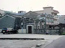
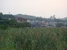
Shan Pui Tsuen is located north of a hill separating it from Yuen Long Kau Hui. A small boat near the village entrance serves as a ferry across the Kam Tin River towards Nam Sang Wai in the north.[4]
History
Shan Pui Tsuen was founded by Lam Siu-yuen (林兆元), a 13th generation member of the Lam Clan, who moved from Tai Wai Tsuen some 200 years ago.[5] Historically, the village was facing a large piece of fishing ponds.[6]
At the time of the 1911 census, the population of Shan Pui was 273. The number of males was 118.[7]
Shan Pui Tsuen is part of the Tung Tau alliance (東頭約)[8] or "Joint Meeting Group of Seven Villages", together with Nam Pin Wai, Tung Tau Tsuen, Choi Uk Tsuen, Ying Lung Wai, Wong Uk Tsuen and Tai Wai Tsuen.[9] The Yi Shing Temple in Wong Uk Tsuen is an alliance temple of the Tung Tau Alliance.[8]
Features
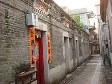
Lam Ancestral Hall (林氏家祠), located at No. 157 Shan Pui Tsuen, in the eastern part of the village,[6] was probably built in the 19th century.[10] The building was used as the classrooms of a school for teaching village children in the 1930s-1960s, and as classrooms of a kindergarten in 1967–1968.[5]
Several old residential houses in the village are Qing vernacular buildings and are considered to have built heritage value.[11]
Education
Shan Pui is in Primary One Admission (POA) School Net 74. Within the school net are multiple aided schools (operated independently but funded with government money) and one government school: Yuen Long Government Primary School (元朗官立小學).[12]
References
- "List of Recognized Villages under the New Territories Small House Policy" (PDF). Lands Department. September 2009.
- "Recommended District Council Constituency Areas (Yuen Long District)" (PDF). Electoral Affairs Commission. Retrieved 10 October 2021.
- "Yuen Long District Council - Yuen Long DC Members". District Council. Retrieved 10 October 2021.
- thaiworldview.com - Shan Pui Tsuen
- Brief Information on No Grade Items, pp.455-456 Archived 2012-10-15 at the Wayback Machine
- Brief Information on Proposed Grade III Items, p.447 Archived 2013-09-22 at the Wayback Machine
- Hase, Patrick (1996). "Traditional Life in the New Territories: The Evidence of the 1911 and 1921 Censuses" (PDF). Journal of the Royal Asiatic Society Hong Kong Branch. 36: 78. ISSN 1991-7295.
- Antiquities Advisory Board. Historic Building Appraisal. Yi Shing Temple, Wong Uk Tsuen
- Press Release: "Property development projects at Nam Cheong and Yuen Long Stations", May 13, 2009
- Introduction to 1444 Historic Buildings, p.1335 Archived 2012-10-13 at the Wayback Machine
- Brief Information on Proposed Grade III Items Archived 2013-09-22 at the Wayback Machine
- "POA School Net 74" (PDF). Education Bureau. Retrieved 2022-10-09.