Guangxin District
Guangxin District (simplified Chinese: 广信区; traditional Chinese: 廣信區; pinyin: Guǎngxìn qū) formerly, Shangrao County (simplified Chinese: 上饶县; traditional Chinese: 上饒縣; pinyin: Shàngráo Xiàn), is a district in the northeast of Jiangxi province, People's Republic of China, bordering Fujian province to the south. It is under the jurisdiction of the prefecture-level city of Shangrao.
Guangxin
广信区 Shangjao | |
|---|---|
.jpg.webp) The town of Wufushan in the January 2016 East Asia cold wave | |
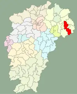 Guangxin in Jiangxi | |
| Coordinates: 28°26′56″N 117°54′29″E | |
| Country | People's Republic of China |
| Province | Jiangxi |
| Prefecture-level city | Shangrao |
| Area | |
| • Total | 2,240 km2 (860 sq mi) |
| Population (2017) | |
| • Total | 848,144 |
| • Density | 380/km2 (980/sq mi) |
| Time zone | UTC+8 (China Standard) |
| Postal Code | 334100 |
Administrative divisions
At present, Guangxin District has 3 subdistricts, 11 towns and 10 townships.[1]
- 3 subdistricts
- Xuri (旭日街道)
- Luoqiao (罗桥街道)
- Xingyuan (兴园街道)
- 11 towns
|
|
- 10 townships
|
|
Demographics
The population of the district was 660,674 in 1999.[2]
Climate
| Climate data for Guangxin (1981−2010 normals) | |||||||||||||
|---|---|---|---|---|---|---|---|---|---|---|---|---|---|
| Month | Jan | Feb | Mar | Apr | May | Jun | Jul | Aug | Sep | Oct | Nov | Dec | Year |
| Record high °C (°F) | 26.1 (79.0) |
29.2 (84.6) |
34.2 (93.6) |
35.9 (96.6) |
36.7 (98.1) |
39.0 (102.2) |
42.0 (107.6) |
41.6 (106.9) |
39.0 (102.2) |
37.4 (99.3) |
32.4 (90.3) |
25.4 (77.7) |
42.0 (107.6) |
| Average high °C (°F) | 10.4 (50.7) |
12.4 (54.3) |
16.8 (62.2) |
23.1 (73.6) |
28.1 (82.6) |
30.6 (87.1) |
35.2 (95.4) |
34.5 (94.1) |
30.5 (86.9) |
25.2 (77.4) |
18.9 (66.0) |
12.9 (55.2) |
23.2 (73.8) |
| Daily mean °C (°F) | 6.1 (43.0) |
8.3 (46.9) |
12.2 (54.0) |
18.0 (64.4) |
23.0 (73.4) |
25.9 (78.6) |
29.8 (85.6) |
29.2 (84.6) |
25.6 (78.1) |
20.3 (68.5) |
13.9 (57.0) |
7.9 (46.2) |
18.4 (65.0) |
| Average low °C (°F) | 3.1 (37.6) |
5.4 (41.7) |
8.9 (48.0) |
14.3 (57.7) |
19.2 (66.6) |
22.5 (72.5) |
25.6 (78.1) |
25.3 (77.5) |
21.9 (71.4) |
16.6 (61.9) |
10.4 (50.7) |
4.5 (40.1) |
14.8 (58.7) |
| Record low °C (°F) | −5.4 (22.3) |
−4.4 (24.1) |
−2.5 (27.5) |
5.3 (41.5) |
10.6 (51.1) |
15.2 (59.4) |
20.6 (69.1) |
20.0 (68.0) |
14.4 (57.9) |
3.8 (38.8) |
0.1 (32.2) |
−5.4 (22.3) |
−5.4 (22.3) |
| Average precipitation mm (inches) | 88.4 (3.48) |
121.6 (4.79) |
202.5 (7.97) |
241.0 (9.49) |
243.6 (9.59) |
376.7 (14.83) |
139.4 (5.49) |
102.9 (4.05) |
79.1 (3.11) |
57.5 (2.26) |
112.8 (4.44) |
77.2 (3.04) |
1,842.7 (72.54) |
| Average precipitation days (≥ 0.1 mm) | 13.8 | 14.6 | 17.6 | 16.5 | 16.2 | 17.6 | 10.7 | 11.7 | 9.0 | 8.0 | 11.3 | 10.7 | 157.7 |
| Average snowy days | 1.7 | 1.3 | 0.2 | 0 | 0 | 0 | 0 | 0 | 0 | 0 | 0 | 0.6 | 3.8 |
| Average relative humidity (%) | 76 | 78 | 76 | 75 | 74 | 77 | 71 | 71 | 73 | 71 | 75 | 74 | 74 |
| Mean monthly sunshine hours | 84.7 | 84.5 | 107.7 | 129.1 | 142.5 | 130.4 | 239.1 | 220.0 | 176.3 | 164.3 | 128.2 | 112.5 | 1,719.3 |
| Percent possible sunshine | 26 | 27 | 29 | 33 | 34 | 31 | 56 | 55 | 48 | 47 | 40 | 35 | 38 |
| Source: China Meteorological Administration (precipitation days, snow days, sunshine 2000–2020)[3][4] | |||||||||||||
Notes and references
- "常州市-行政区划网 www.xzqh.org" (in Chinese). XZQH. Retrieved 2012-05-24.
- (in English) National Population Statistics Materials by County and City - 1999 Period, in China County & City Population 1999, Harvard China Historical GIS
- 中国气象数据网 – WeatherBk Data (in Simplified Chinese). China Meteorological Administration. Retrieved 30 July 2023.
- 中国气象数据网 (in Simplified Chinese). China Meteorological Administration. Retrieved 30 July 2023.
This article is issued from Wikipedia. The text is licensed under Creative Commons - Attribution - Sharealike. Additional terms may apply for the media files.