Shingū, Wakayama
Shingū (新宮市, Shingū-shi) is a city located in Wakayama Prefecture, Japan. As of 1 November 2021, the city had an estimated population of 27,491 in 14649 households and a population density of 110 persons per km2.[1] The total area of the city is 255.23 square kilometres (98.54 sq mi). Shingū literally means 'New Shrine' and refers to Hayatama Shrine, one of the Three Grand Shrines of Kumano (See[2]). The 'old shrine' would be Kamikura Shrine.
Shingū
新宮市 | |
|---|---|
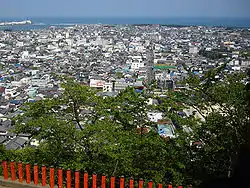 Skyline of Shingū viewed from Kamikura Shrine | |
 Flag  Seal | |
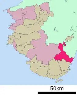 Location of Shingū in Wakayama Prefecture | |
 Shingū Location in Japan | |
| Coordinates: 33°43′N 136°0′E | |
| Country | Japan |
| Region | Kansai |
| Prefecture | Wakayama |
| First official recorded | 33 BC |
| City settled | October 1, 1933 |
| Government | |
| • Mayor | Michitoshi Taoka (since November 2009) |
| Area | |
| • Total | 255.23 km2 (98.54 sq mi) |
| Population (November 1, 2021) | |
| • Total | 27,491 |
| • Density | 110/km2 (280/sq mi) |
| Time zone | UTC+09:00 (JST) |
| City hall address | 1-1 Kasuga, Shingū-shi, Wakayama-ken 647-8555 |
| Climate | Cfa |
| Website | Official website |
| Symbols | |
| Flower | Crinum asiaticum and Kawasatsuki |
| Tree | Nageia nagi, Kumano sugi, Tendaiuyaku (Lindera strychnifolia) |
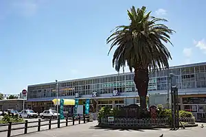
.jpg.webp)
Geography
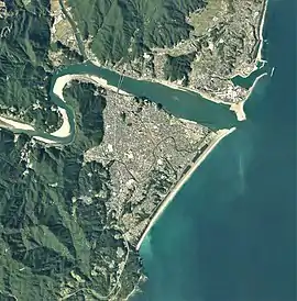
Shingū is located near the southern tip of Wakayama Prefecture on the Kii Peninsula, on the west side of the mouth of the Kumano River. It faces the Pacific Ocean to the east. Parts of the city are within the limits of the Yoshino-Kumano National Park.
Neighboring municipalities
Wakayama Prefecture
Mie Prefecture
Nara Prefecture
Climate
Shingū has a Humid subtropical climate (Köppen Cfa) characterized by warm summers and cool winters with light to no snowfall. The average annual temperature in Shingū is 17.3 °C (63.1 °F). The average annual rainfall is 3,332.9 mm (131.22 in) with June as the wettest month. The temperatures are highest on average in August, at around 27.2 °C (81.0 °F), and lowest in January, at around 7.6 °C (45.7 °F).[3] The area is subject to typhoons in summer. The highest temperature ever recorded in Shingū was 38.4 °C (101.1 °F) on 22 August 2016.[4] The coldest temperature ever recorded was −4.6 °C (23.7 °F) on 27 February 1981.[4]
| Climate data for Shingū (1991−2020 normals, extremes 1979−present) | |||||||||||||
|---|---|---|---|---|---|---|---|---|---|---|---|---|---|
| Month | Jan | Feb | Mar | Apr | May | Jun | Jul | Aug | Sep | Oct | Nov | Dec | Year |
| Record high °C (°F) | 21.7 (71.1) |
24.8 (76.6) |
27.8 (82.0) |
31.5 (88.7) |
34.2 (93.6) |
36.3 (97.3) |
37.9 (100.2) |
38.4 (101.1) |
37.4 (99.3) |
32.8 (91.0) |
27.1 (80.8) |
24.0 (75.2) |
38.4 (101.1) |
| Average high °C (°F) | 11.9 (53.4) |
12.8 (55.0) |
15.7 (60.3) |
19.9 (67.8) |
23.3 (73.9) |
25.8 (78.4) |
30.0 (86.0) |
30.9 (87.6) |
28.0 (82.4) |
23.7 (74.7) |
19.1 (66.4) |
14.3 (57.7) |
21.3 (70.3) |
| Daily mean °C (°F) | 7.6 (45.7) |
8.3 (46.9) |
11.3 (52.3) |
15.7 (60.3) |
19.4 (66.9) |
22.4 (72.3) |
26.3 (79.3) |
27.2 (81.0) |
24.6 (76.3) |
20.0 (68.0) |
15.0 (59.0) |
9.9 (49.8) |
17.3 (63.2) |
| Average low °C (°F) | 3.6 (38.5) |
4.2 (39.6) |
7.0 (44.6) |
11.5 (52.7) |
15.7 (60.3) |
19.4 (66.9) |
23.3 (73.9) |
24.3 (75.7) |
21.8 (71.2) |
16.9 (62.4) |
11.4 (52.5) |
6.0 (42.8) |
13.8 (56.8) |
| Record low °C (°F) | −3.4 (25.9) |
−4.6 (23.7) |
−1.7 (28.9) |
2.3 (36.1) |
8.7 (47.7) |
13.8 (56.8) |
17.3 (63.1) |
18.0 (64.4) |
13.5 (56.3) |
7.2 (45.0) |
2.5 (36.5) |
−0.9 (30.4) |
−4.6 (23.7) |
| Average precipitation mm (inches) | 110.1 (4.33) |
151.8 (5.98) |
259.8 (10.23) |
299.1 (11.78) |
311.7 (12.27) |
444.6 (17.50) |
342.2 (13.47) |
276.4 (10.88) |
443.0 (17.44) |
401.0 (15.79) |
184.0 (7.24) |
109.6 (4.31) |
3,332.9 (131.22) |
| Average precipitation days (≥ 1.0 mm) | 6.4 | 7.4 | 10.8 | 10.7 | 11.2 | 15.0 | 12.6 | 11.9 | 13.8 | 11.9 | 8.1 | 6.1 | 125.9 |
| Mean monthly sunshine hours | 200.1 | 182.6 | 196.4 | 196.2 | 183.7 | 127.4 | 174.4 | 209.1 | 145.8 | 149.4 | 165.1 | 194.2 | 2,124.3 |
| Source: Japan Meteorological Agency[4][3] | |||||||||||||
Demographics
Per Japanese census data,[5] the population of Shingū has decreased steadily over the past 60 years.
| Year | Pop. | ±% |
|---|---|---|
| 1960 | 45,666 | — |
| 1970 | 42,073 | −7.9% |
| 1980 | 42,428 | +0.8% |
| 1990 | 38,140 | −10.1% |
| 2000 | 35,176 | −7.8% |
| 2010 | 31,493 | −10.5% |
History
The area of the modern city of Shingū was within ancient Kii Province, and per the Nihon Shoki was the home of the Kumano Kuni no miyatsuko, a local king ruling the Kumano region which straddles what is now southern Wakayama and Mie prefectures. The settlement had prospered since before the Kamakura period as a timber distribution center using the Kumano River, and as an entrance to the Kumano Sanzan shrines. During the Edo period, it was part of the holdings of the Kii Tokugawa clan, and was the castle town of the Shingū Domain during the Edo period. After the Meiji restoration, the area became part of the Higashimuro District, Wakayama, and the town of Shingū was established with the creation of the modern municipalities system on April 1, 1889. Shingū and the neighboring town of Miwasaki merged to form the city of Shingū on October 1, 1933. Shingū annexed the village of Takeda on September 30, 1956. On October 1, 2005, the town of Kumanogawa (from Higashimuro District), an exclave between Nara and Mie prefectures, was merged with Shingū.
Government
Shingū has a mayor-council form of government with a directly elected mayor and a unicameral city council of 15 members. Shingū contributes one member to the Wakayama Prefectural Assembly. In terms of national politics, the city is part of Wakayama 3rd district of the lower house of the Diet of Japan.
Economy
Shingū is the central commercial city of the Kumano Region and is one of the largest cities in Wakayama Prefecture. Primary industries include forestry, commercial fishing, growing of leafy vegetables such as komatsuna and horticulture, and "Kumano brand" beef. Secondary industries are centered around timber and paper processing.
Education
Shingū has five public elementary schools and five public middle schools operated by the city government and two public high schools operated by the Wakayama Prefectural Department of Education. The city also has one private middle school and one private high school. The prefecture also operates one special education school for the handicapped, and one vocational education school.
Transportation
Highway
 Nachikatsuura-Shingū Road
 National Route 42
 National Route 168
 National Route 169
 National Route 311
Local attractions
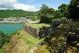
- Shingū Castle ruins, National Historic Site
- Kumano Hayatama Taisha, one of the Kumano Sanzan shrines
- Ōmine Okugakemichi and the Kumano Kodō, parts of the Sacred Sites and Pilgrimage Routes in the Kii Mountain Range, a UNESCO World Heritage Site
- Kumano River
- Kamikura Shrine, with the object of worship a great sacred rock called "Gotobiki-iwa".
Cuisine
A main dish is Nare-zushi, a very traditional type of sushi which, centuries ago, was imported from Southeast Asia to China, and from China to Japan. Narezushi was the birth of sushi, and influenced how the Japanese later made their own styles of sushi that most of us know today.
Sister city relations
Notable people from Shingū
- Yasuyuki Kishino, football player and manager
- Haruo Satō, former novelist and poet
- Kenji Nakagami, novelist
References
- "Shingū city official statistics" (in Japanese). Japan.
- "Home". kumano-world.org.
- 気象庁 / 平年値(年・月ごとの値). JMA. Retrieved April 4, 2022.
- 観測史上1~10位の値(年間を通じての値). JMA. Retrieved April 4, 2022.
- Shingū population statistics
- "Santa Cruz City Sister Cities Commission - Official Web Site". Archived from the original on 2009-04-14. Retrieved 2009-05-01.
External links
 Media related to Shingū, Wakayama at Wikimedia Commons
- Shingū City official website (in Japanese)
- Shingu City Tourist Association