Sêrxü County
Sêrxü County (Tibetan: སེར་ཤུལ་རྫོང་།; Chinese: 石渠县), also known as Sershul, Dzachuka, Serxu, or Shiqu is a county of the Garzê Tibetan Autonomous Prefecture in the northwest of Sichuan Province, China, bordering Qinghai to the west and the Tibet Autonomous Region to the southwest.
Sêrxü County
石渠县 · སེར་ཤུལ་རྫོང་། Sershul, Dzachuka, Serxu, Shiqu | |
|---|---|
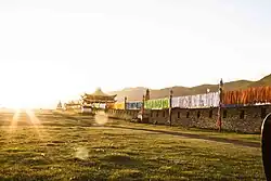
 "Muri Mani" stone sutra | |
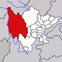
.png.webp) Location of Sêrxü County (red) within Garzê Prefecture (yellow) and Sichuan | |
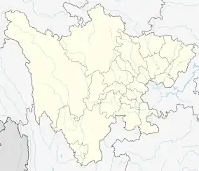
 Sêrxü Location of the seat in Sichuan  Sêrxü Sêrxü (China) | |
| Coordinates: 32°58′44″N 98°06′10″E | |
| Country | China |
| Province | Sichuan |
| Autonomous prefecture | Garzê |
| County seat | Jugar (Niga) |
| Area | |
| • Total | 24,944 km2 (9,631 sq mi) |
| Population (2020)[1] | |
| • Total | 103,633 |
| • Density | 4.2/km2 (11/sq mi) |
| Time zone | UTC+8 (China Standard) |
| Website | www |
| Sêrxü County | |||||||
|---|---|---|---|---|---|---|---|
| Chinese name | |||||||
| Simplified Chinese | 石渠县 | ||||||
| Traditional Chinese | 石渠縣 | ||||||
| |||||||
| Tibetan name | |||||||
| Tibetan | སེར་ཤུལ་རྫོང་། | ||||||
| |||||||
Geography

Sêrxü (sershul) County is situated at the northwest corner of Sichuan province, and is also the westernmost county-level division of the province. Its area is approximately 25,000 km2, mainly covered by grasslands. The average elevation is 4,200 m above sea level.
It has an area of over 25,000 square kilometers and is predominantly covered by grasslands used for nomadic herding. The population is around 68,000, 96% of whom are ethnic Tibetan.
By the end of 1997, there was an estimated livestock population of 581,470. These were mainly yaks, sheep, goats, and horses, but there was a small number of pigs. The human population of Shiqu County was approximately 63,400, 96.8% of which were ethnic Tibetans. There were 49,100 herdsmen, representing 77.6% of the population.
Sershul District villages include: Ariksar, Bumser, Changma, Dezhongma, Dzagyel, Geming, Gotsa, Junyung, Jowo, Kabshi, Kilung, Kyewu, Sershul Gompa, Serxu Dzong, Shaksa, Tromsa Genma, Tseboum Soumdo, Tsemkhog, Ombo and Wathul.
Sershul District has several monasteries, including: Ju Mohar, Sershul Monastery, Bumser Gonpo, Ariksar, Dzagyel, Changma, Trikar, Kabshi and Jowo; and the Gsumge Mani Stone Castle, a religious complex built out of mani stone tablets.
Administrative divisions
Sêrxü County is divided into 7 towns and 14 townships:
| Name | Simplified Chinese | Hanyu Pinyin | Tibetan | Wylie | Administrative division code | |
|---|---|---|---|---|---|---|
| Towns | ||||||
| Jugar Town (Niga) |
尼呷镇 | Nígā Zhèn | འཇུ་སྒར་གྲོང་རྡལ། | 'ju sgar grong rdal | 513332100 | |
| Loqug Town (Loqung) |
洛须镇 | Luòxū Zhèn | ལོ་ཕྱུག་གྲོང་རྡལ། | lo phyug grong rdal | 513332101 | |
| Sêrxü Town (Sênxü, Sexu) |
色须镇 | Sèxū Zhèn | སེར་ཤུལ་གྲོང་རྡལ། | ser shul grong rdal | 513332102 | |
| Qagca Town (Xiazha) |
虾扎镇 | Xiāzhā Zhèn | ཕྱག་ཚ་གྲོང་རྡལ། | phyag tsha grong rdal | 513332103 | |
| Woinbo Town (Wenbo) |
温波镇 | Wēnbō Zhèn | དབོན་པོ་གྲོང་རྡལ། | dbon po grong rdal | 513332104 | |
| Bumnying Town (Mengyi) |
蒙宜镇 | Méngyí Zhèn | འབུམ་རྙིང་གྲོང་རྡལ། | 'bum rnying grong rdal | 513332105 | |
| Arigza Town (Arizha) |
阿日扎镇 | Ārìzhā Zhèn | ཨ་རིག་རྫ་གྲོང་རྡལ། | a rig rdza grong rdal | 513332106 | |
| Townships | ||||||
| Zênda Township (Zhenda) |
真达乡 | Zhēndá Xiāng | རྩེ་མདའ་ཤང་། | rtse mda' shang | 513332200 | |
| Pênda Township (Benda) |
奔达乡 | Bēndá Xiāng | བེ་མདའ་ཤང་། | be mda' shang | 513332201 | |
| Zhêngko Township (Zhengke) |
正科乡 | Zhèngkē Xiāng | ཀྲེང་ཁོ་ཤང་། | kreng kho shang | 513332202 | |
| Dêxungma Township (De'ongma, Derongma) |
德荣马乡 | Déróngmǎ Xiāng | སྡེ་གཞུང་མ་ཤང་། | sde gzhung ma shang | 513332204 | |
| Chomsagabma Township (Changshagongma) |
长沙贡马乡 | Chángshāgóngmǎ Xiāng | ཁྲོམ་བཟའ་འགབ་མ་ཤང་། | khrom bza' 'gab ma shang | 513332206 | |
| Gaxi Township (Gayi) |
呷衣乡 | Gāyī Xiāng | ཀ་བཞི་ཤང་། | ka bzhi shang | 513332207 | |
| Gêmang Township (Gemeng) |
格孟乡 | Gémèng Xiāng | དགེ་མང་ཤང་། | dge mang shang | 513332208 | |
| Xinrung Township (Xinrong) |
新荣乡 | Xīnróng Xiāng | ཤིན་རུང་ཤང་། | shin rung shang | 513332210 | |
| Ju'nying Township (Yiniu) |
宜牛乡 | Yíniú Xiāng | འཇུ་རྙིང་ཤང་། | 'ju rnying shang | 513332211 | |
| Kyiu Township (Kyewu, Qiwu) |
起坞乡 | Qǐwū Xiāng | ཁྱེའུ་ཤང་། | khye'u shang | 513332213 | |
| Choxükongma Township (Changxugongma) |
长须贡马乡 | Chángxūgòngmǎ Xiāng | ཁྲོ་ཤུལ་གོང་མ་ཤང་། | khro shul gong ma shang | 513332215 | |
| Chomzagabma Township (Chomsakongma, Changshaganma) |
长沙干马乡 | Chángshāgānmǎ Xiāng | ཁྲོམ་རྫ་འགབ་མ་ཤང་། | khrom rdza 'gab ma shang | 513332216 | |
| Choxügabma Township (Changxuganma) |
长须干马乡 | Chángxūgānmǎ Xiāng | ཁྲོ་ཤུལ་འགབ་མ་ཤང་། | khro shul 'gab ma shang | 513332217 | |
| Waxü Township (Waxu) |
瓦须乡 | Wǎxū Xiāng | ཝ་ཤུལ་ཤང་། | wa shul shang | 513332219 | |
Demographics
The population of the district was 62,408 inhabitants in 1999.[2]
There are about 52,660 nomads in the district, or 77.6% of the population.
Climate
| Climate data for Sêrxü (1991–2020 normals, extremes 1981–2010) | |||||||||||||
|---|---|---|---|---|---|---|---|---|---|---|---|---|---|
| Month | Jan | Feb | Mar | Apr | May | Jun | Jul | Aug | Sep | Oct | Nov | Dec | Year |
| Record high °C (°F) | 12.1 (53.8) |
10.2 (50.4) |
14.8 (58.6) |
17.5 (63.5) |
20.7 (69.3) |
23.1 (73.6) |
23.5 (74.3) |
22.6 (72.7) |
21.7 (71.1) |
19.1 (66.4) |
12.5 (54.5) |
10.0 (50.0) |
23.5 (74.3) |
| Average high °C (°F) | −2.4 (27.7) |
0.0 (32.0) |
3.3 (37.9) |
7.2 (45.0) |
11.0 (51.8) |
14.0 (57.2) |
16.0 (60.8) |
15.9 (60.6) |
13.3 (55.9) |
7.4 (45.3) |
2.4 (36.3) |
−1.0 (30.2) |
7.3 (45.1) |
| Daily mean °C (°F) | −11.5 (11.3) |
−8.3 (17.1) |
−4.3 (24.3) |
0.0 (32.0) |
3.9 (39.0) |
7.4 (45.3) |
9.3 (48.7) |
8.7 (47.7) |
5.9 (42.6) |
0.0 (32.0) |
−6.2 (20.8) |
−10.5 (13.1) |
−0.5 (31.2) |
| Average low °C (°F) | −19.4 (−2.9) |
−15.7 (3.7) |
−10.8 (12.6) |
−5.8 (21.6) |
−1.8 (28.8) |
2.4 (36.3) |
3.8 (38.8) |
2.8 (37.0) |
0.6 (33.1) |
−5.2 (22.6) |
−13 (9) |
−18.5 (−1.3) |
−6.7 (19.9) |
| Record low °C (°F) | −37.2 (−35.0) |
−31.8 (−25.2) |
−27.5 (−17.5) |
−15.9 (3.4) |
−11.2 (11.8) |
−6.0 (21.2) |
−4.1 (24.6) |
−7.9 (17.8) |
−10.0 (14.0) |
−20.3 (−4.5) |
−30.3 (−22.5) |
−37.8 (−36.0) |
−37.8 (−36.0) |
| Average precipitation mm (inches) | 7.5 (0.30) |
10.0 (0.39) |
16.7 (0.66) |
28.8 (1.13) |
62.0 (2.44) |
108.6 (4.28) |
118.3 (4.66) |
92.1 (3.63) |
92.6 (3.65) |
46.4 (1.83) |
6.9 (0.27) |
4.0 (0.16) |
593.9 (23.4) |
| Average precipitation days (≥ 0.1 mm) | 6.7 | 7.9 | 12.5 | 15.4 | 20.3 | 23.8 | 20.8 | 18.5 | 20.8 | 16.0 | 6.5 | 4.8 | 174 |
| Average snowy days | 8.9 | 11.5 | 15.9 | 19.5 | 19.4 | 5.8 | 1.2 | 1.1 | 7.8 | 18.3 | 9.2 | 7.2 | 125.8 |
| Average relative humidity (%) | 45 | 45 | 48 | 55 | 62 | 68 | 68 | 69 | 71 | 67 | 53 | 46 | 58 |
| Mean monthly sunshine hours | 205.0 | 188.2 | 203.9 | 207.1 | 199.9 | 170.6 | 191.6 | 190.2 | 177.1 | 188.4 | 210.2 | 211.4 | 2,343.6 |
| Percent possible sunshine | 64 | 60 | 55 | 53 | 46 | 40 | 44 | 47 | 48 | 54 | 68 | 68 | 54 |
| Source: China Meteorological Administration[3][4] | |||||||||||||
References
- "甘孜州第七次全国人口普查公报(第二号)" (in Chinese). Government of Garzê Prefecture. 2021-06-04.
- (in English) National Population Statistics Materials by County and City - 1999 Period, in China County & City Population 1999, Harvard China Historical GIS
- 中国气象数据网 – WeatherBk Data (in Simplified Chinese). China Meteorological Administration. Retrieved 13 April 2023.
- 中国气象数据网 (in Simplified Chinese). China Meteorological Administration. Retrieved 13 April 2023.

