Shirakawa Barrier
The Shirakawa Barrier (白河の関, Shirakawa no seki) is the location of a frontier fortification on the Ōshū Kaidō highway in what is now the Hatajuku neighborhood of the city of Shirakawa, Fukushima Japan, three kilometers south of the border of Tochigi Prefecture[1] The site was designated a National Historic Site in 1966.,[2] and is part of the Shirakawa Seki-no-mori Park, containing a reconstructed ancient house and preserved old farm houses.
白河の関 | |
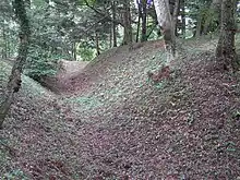
 Remnant of moat of Shirakawa Barrier | |
 Shown within Fukushima Prefecture  Shirakawa Barrier (Japan) | |
| Location | Shirakawa, Fukushima, Japan |
|---|---|
| Region | Tōhoku region |
| Coordinates | 37°2′49.1″N 140°13′43.6″E |
| Type | fortification |
| History | |
| Founded | Nara period |
| Site notes | |
| Excavation dates | 1956-1963 |
| Ownership | National Historic Site |
| Public access | Yes |
History
The barrier is one of three built during the Nara period to mark the border between the territory controlled by the Yamato state and the Emishi tribes of the Tōhoku region of northern Honshū, although there is archaeological evidence to show that it may actually date to as early as the latter half of the 5th century in the Kofun period. Its first appearance in historical records is dated December 3, 835, at which time the barrier is mentioned to be four hundred years old. The barrier served as a border fortress against excursions of the Emishi to the south, and to regulate and control traffic from the central provinces of Japan to the north. During the Nara period, it marked the northern border of Yamato control.
By the early to mid-Heian period, Yamato forces gradually conquered the Emishi, and the barrier fell into ruin as it had become redundant. It had largely vanished by the start of the Kamakura period. However, memory of the barrier was preserved as an utamakura in Japanese poetry, metaphorically evoking images of distance, transition and loneliness. The site was lost until the mid-Edo period, when it was rediscovered by Matsudaira Sadanobu, daimyō of Shirakawa Domain based on a study of ancient texts in the year 1800. He marked the location with a stone monument and the construction of a Shinto shrine, the Shirakawa Jinja.
The site was excavated by archaeologists from 1956 to 1963, and the remains of a dry moat, a double wooden palisade and earthen ramparts were uncovered,[1] along with the foundations of pit dwellings and blacksmith workshops.
References
- Campbell, Allen; Nobel, David S (1993). Japan: An Illustrated Encyclopedia. Kodansha. p. 904. ISBN 406205938X.
- "白河関跡" [Aizu-Shirakawa no seki ato] (in Japanese). Agency for Cultural Affairs.
- Haruo Shirane (2008). Early Modern Japanese Literature: An Anthology, 1600-1900. Columbia University Press. ISBN 978- 0-231-14415-5.
- Edward Kamens (1997). Utamakura, Allusion, and Intertextuality in Traditional Japanese Poetry. Yale University Press. ISBN 978-0-300-06808-5.
- Donald Keene (1999). Travelers of a Hundred Ages: The Japanese As Revealed Through 1,000 Years of Diaries. Columbia University Press. ISBN 978-0-231-11437-0.
External links
![]() Media related to Shirakawa no Seki at Wikimedia Commons
Media related to Shirakawa no Seki at Wikimedia Commons
- Shirakawa city official home page (in Japanese)