Golden Plains Shire
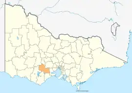
The Golden Plains Shire is a local government area in Victoria, Australia, located in the western part of the state. It covers an area of 2,703 square kilometres (1,044 sq mi) and in June 2018, had a population of 23,120.[1] It includes the towns of Bannockburn, Dereel, Gheringhap, Lethbridge, Linton, Berringa, Teesdale, Rokewood and Meredith.
| Golden Plains Shire Victoria | |||||||||||||||
|---|---|---|---|---|---|---|---|---|---|---|---|---|---|---|---|
 Typical scenery of the Golden Plains Shire. | |||||||||||||||
 | |||||||||||||||
| Population | 23,120 (2018)[1] | ||||||||||||||
| • Density | 8.553/km2 (22.153/sq mi) | ||||||||||||||
| Established | 1994 | ||||||||||||||
| Gazetted | 6 May 1994[2] | ||||||||||||||
| Area | 2,703 km2 (1,043.6 sq mi)[1] | ||||||||||||||
| Mayor | Cr Gavin Gamble[3] | ||||||||||||||
| Council seat | Bannockburn | ||||||||||||||
| Region | Grampians | ||||||||||||||
| State electorate(s) | |||||||||||||||
| Federal division(s) | |||||||||||||||
| Website | Golden Plains Shire | ||||||||||||||
| |||||||||||||||
The Shire was formed on 6 May 1994 by the amalgamation of the Shire of Bannockburn (the part remaining after part of it was amalgamated with several other councils to form the new City of Greater Geelong in May 1993), Shire of Leigh, part of the Shire of Grenville and part of the Shire of Buninyong. Upon its creation, it was known as the Southern Rural Shire, intended to exist temporarily until the Local Government Board drew up final council boundaries for the Ballarat region.[4] However, a few months later it was decided to make the municipality permanent, and it was renamed to its current name on 1 October 1994.[2][5]
The Shire is governed and administered by the Golden Plains Shire Council. Its seat of local government and administrative centre is located at the Golden Plains Civic Centre in Bannockburn, and it also has a service centre located in Smythesdale.[6]
Council
Current composition
The council is composed of seven councillors elected to represent an unsubdivided municipality. The current councillors, in order of election at the 2022 election, are:[7]
| Ward | Party | Councillor | |
|---|---|---|---|
| Unsubdivided | Independent | Brett Cunningham | |
| Independent | Owen Sharkey | ||
| Independent | Ian Getsom | ||
| Independent | Helena Kirby | ||
| Greens | Gavin Gamble | ||
| Independent | Clayton Whitfield | ||
| Independent | Les Rowe | ||
Administration and governance
The council meets on alternate months in the council chamber at the Golden Plains Civic Centre in Bannockburn, which is also the location of the council's administrative activities, and at the Linton Shire Hall.[8] It also provides customer services at both its administrative centre in Bannockburn, and its service centre in Smythesdale.
Climate
| Climate data for She Oaks (She Oaks 1991–2020, records 1990–2020) | |||||||||||||
|---|---|---|---|---|---|---|---|---|---|---|---|---|---|
| Month | Jan | Feb | Mar | Apr | May | Jun | Jul | Aug | Sep | Oct | Nov | Dec | Year |
| Record high °C (°F) | 43.7 (110.7) |
45.2 (113.4) |
39.3 (102.7) |
33.4 (92.1) |
26.6 (79.9) |
23.6 (74.5) |
20.8 (69.4) |
23.2 (73.8) |
28.4 (83.1) |
35.2 (95.4) |
39.1 (102.4) |
42.0 (107.6) |
45.2 (113.4) |
| Average high °C (°F) | 26.1 (79.0) |
25.5 (77.9) |
23.1 (73.6) |
19.3 (66.7) |
15.6 (60.1) |
12.9 (55.2) |
12.3 (54.1) |
13.3 (55.9) |
15.5 (59.9) |
18.4 (65.1) |
21.2 (70.2) |
23.8 (74.8) |
18.9 (66.0) |
| Daily mean °C (°F) | 19.3 (66.7) |
19.2 (66.6) |
17.2 (63.0) |
14.1 (57.4) |
11.5 (52.7) |
9.2 (48.6) |
8.7 (47.7) |
9.3 (48.7) |
10.9 (51.6) |
12.9 (55.2) |
15.2 (59.4) |
17.2 (63.0) |
13.7 (56.7) |
| Average low °C (°F) | 12.4 (54.3) |
12.8 (55.0) |
11.2 (52.2) |
8.8 (47.8) |
7.3 (45.1) |
5.5 (41.9) |
5.1 (41.2) |
5.3 (41.5) |
6.2 (43.2) |
7.3 (45.1) |
9.1 (48.4) |
10.5 (50.9) |
8.5 (47.3) |
| Record low °C (°F) | 2.0 (35.6) |
2.9 (37.2) |
−0.9 (30.4) |
−2.2 (28.0) |
−2.9 (26.8) |
−3.5 (25.7) |
−4.2 (24.4) |
−3.1 (26.4) |
−2.5 (27.5) |
−1.8 (28.8) |
−0.2 (31.6) |
−0.6 (30.9) |
−4.2 (24.4) |
| Average precipitation mm (inches) | 34.3 (1.35) |
39.9 (1.57) |
24.6 (0.97) |
38.8 (1.53) |
38.3 (1.51) |
41.8 (1.65) |
40.8 (1.61) |
43.8 (1.72) |
48.2 (1.90) |
51.9 (2.04) |
59.5 (2.34) |
30.6 (1.20) |
493.6 (19.43) |
| Average rainy days | 7.4 | 7.5 | 8.3 | 11.1 | 14.8 | 15.7 | 17.5 | 17.0 | 15.7 | 13.1 | 10.3 | 8.5 | 146.9 |
| Average afternoon relative humidity (%) | 47 | 48 | 49 | 54 | 66 | 72 | 70 | 65 | 63 | 58 | 56 | 48 | 58 |
| Source: [9] | |||||||||||||
Townships and localities
The 2021 census, the shire had a population of 24,985 up from 21,688 in the 2016 census[10]
| Population | ||
|---|---|---|
| Locality | 2016 | 2021 |
| Anakie^ | 690 | 734 |
| Bamganie | 37 | 44 |
| Bannockburn | 5,283 | 6,470 |
| Barunah Park | 27 | 33 |
| Batesford^ | 952 | 1,141 |
| Berringa | 167 | 194 |
| Berrybank^ | 40 | 37 |
| Cambrian Hill | 251 | 292 |
| Campbelltown^ | 55 | 51 |
| Cape Clear | 125 | 148 |
| Corindhap | 132 | 131 |
| Cressy^ | 175 | 176 |
| Dereel | 533 | 664 |
| Durdidwarrah | 9 | 12 |
| Durham Lead^ | 392 | 408 |
| Enfield | 538 | 574 |
| Population | ||
|---|---|---|
| Locality | 2016 | 2021 |
| Garibaldi | 123 | 131 |
| Gheringhap | 155 | 132 |
| Glengower^ | 13 | 15 |
| Grenville^ | 99 | 113 |
| Haddon | 1,194 | 1,276 |
| Happy Valley | 85 | 87 |
| Hesse | 19 | 14 |
| Illabarook | 32 | 41 |
| Inverleigh^ | 1,474 | 1,746 |
| Lethbridge | 1,014 | 1,181 |
| Linton^ | 580 | 635 |
| Mannibadar | 80 | 65 |
| Maude | 223 | 211 |
| Meredith^ | 788 | 821 |
| Morrisons^ | 128 | 118 |
| Population | ||
|---|---|---|
| Locality | 2016 | 2021 |
| Mount Bute^ | 58 | 61 |
| Mount Cameron^ | 9 | 15 |
| Mount Mercer | 69 | 94 |
| Murgheboluc | 131 | 132 |
| Napoleons | 553 | 555 |
| Newtown | 122 | 189 |
| Nintingbool | 173 | 168 |
| Piggoreet | 37 | 17 |
| Pitfield | 48 | 14 |
| Pittong^ | 15 | 12 |
| Rokewood | 217 | 208 |
| Rokewood Junction | 32 | 34 |
| Ross Creek | 1,153 | 1,221 |
| Russells Bridge | 67 | 70 |
| Scarsdale | 744 | 855 |
| Population | ||
|---|---|---|
| Locality | 2016 | 2021 |
| She Oaks | 107 | 126 |
| Shelford | 253 | 263 |
| Smythes Creek^ | 1,467 | 1,762 |
| Smythesdale^ | 1,032 | 1,189 |
| Springdallah | 26 | 35 |
| Staffordshire Reef | 45 | 63 |
| Steiglitz | 53 | 61 |
| Stonehaven | 81 | 79 |
| Stony Creek | 6 | 0 |
| Sutherlands Creek | 108 | 129 |
| Teesdale | 1,721 | 2,308 |
| Wallinduc | 37 | 42 |
| Werneth^ | 60 | 66 |
| Willowvale | 7 | 10 |
| Wingeel^ | 23 | 26 |
^ - Territory divided with another LGA
References
- "3218.0 – Regional Population Growth, Australia, 2017-18: Population Estimates by Local Government Area (ASGS 2018), 2017 to 2018". Australian Bureau of Statistics. Australian Bureau of Statistics. 27 March 2019. Retrieved 25 October 2019. Estimated resident population, 30 June 2018.
- Victoria Government Gazette – Online Archive (1837–1997). "Order establishing (Part 3) the Southern Rural Shire". State Library of Victoria. State Government of Victoria (published 6 May 1994). p. 1. Retrieved 10 January 2014.
- "My Councillors | Golden Plains Shire Council".
- "Golden Plains Shire 20th Annual Report" (PDF). Golden Plains Shire. Retrieved 31 May 2018.
- Victoria Government Gazette – Online Archive (1837–1997). "Order to provide transitional arrangements for the Golden Plains Shire Council in respect of its proposed budget for the 1995–1996 financial year". State Library of Victoria. State Government of Victoria (published 24 August 1995). p. 1. Retrieved 31 May 2018.
- "Contact Us | Golden Plains Shire Council". www.goldenplains.vic.gov.au. Retrieved 12 July 2021.
- "Golden Plains Shire Council election results 2020". www.vec.vic.gov.au. Retrieved 11 November 2020.
- "Meetings, minutes and agenda | Golden Plains Shire Council". www.goldenplains.vic.gov.au. Retrieved 12 July 2021.
- "Climate statistics for Australian locations". Australian Bureau of Meteorology. Retrieved 2 November 2021.
- "Census | Australian Bureau of Statistics". www.abs.gov.au. 11 January 2023.
External links
- Golden Plains Shire Council official website
- Metlink local public transport map
- Link to Land Victoria interactive maps
Localities in the Golden Plains Shire | ||
|---|---|---|
| Town |
|  |
| Locality |
| |
^ - Territory divided with another LGA | ||