Shire of Wongan–Ballidu
The Shire of Wongan–Ballidu is a local government area in the Wheatbelt region of Western Australia, about 180 kilometres (112 mi) NNE of Perth, the state capital. The Shire covers an area of 3,369 square kilometres (1,301 sq mi) and its seat of government is the town of Wongan Hills. The shire includes the Wongan Hills, after which the town is named.
| Shire of Wongan-Ballidu Western Australia | |||||||||||||||
|---|---|---|---|---|---|---|---|---|---|---|---|---|---|---|---|
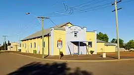
 Ballidu Hall, 2014 | |||||||||||||||
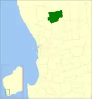
 Location in Western Australia | |||||||||||||||
| Population | 1,297 (LGA 2021)[1] | ||||||||||||||
| Established | 1887 | ||||||||||||||
| Area | 3,368.7 km2 (1,300.7 sq mi) | ||||||||||||||
| Shire President | Mandy Stephenson | ||||||||||||||
| Council seat | Wongan Hills | ||||||||||||||
| Region | Wheatbelt | ||||||||||||||
| State electorate(s) | Moore | ||||||||||||||
| Federal division(s) | Durack | ||||||||||||||
 | |||||||||||||||
| Website | Shire of Wongan-Ballidu | ||||||||||||||
| |||||||||||||||
History
On 10 February 1887, the Melbourne Road District was created. It was renamed the Wongan-Ballidu Road District on 18 June 1926. On 1 July 1961, it became a shire following the passage of the Local Government Act 1960, which reformed all remaining road districts into shires.[2]
Wards
As of 3 May 2003, there are ten councillors and no wards. The mayor is directly elected.
Towns and localities
The towns and localities of the Shire of X with population and size figures based on the most recent Australian census:[3][4]
| Locality | Population | Area | Map |
|---|---|---|---|
| Ballidu | 58 (SAL 2021)[5] | 8.5 km2 (3.3 sq mi) | |
| Burakin | 30 (SAL 2021)[6] | 342.5 km2 (132.2 sq mi) | |
| Cadoux | 56 (SAL 2021)[7] | 448.5 km2 (173.2 sq mi) | |
| East Ballidu | 35 (SAL 2021)[8] | 429.9 km2 (166.0 sq mi) | |
| Kondut | 41 (SAL 2021)[9] | 510.2 km2 (197.0 sq mi) | |
| Lake Hinds | 29 (SAL 2021)[10] | 329.5 km2 (127.2 sq mi) | |
| Lake Ninan | 17 (SAL 2021)[11] | 242.5 km2 (93.6 sq mi) | |
| Mocardy | 89 (SAL 2021)[12] | 473.5 km2 (182.8 sq mi) | |
| West Ballidu | 44 (SAL 2021)[13] | 343.3 km2 (132.5 sq mi) | |
| Wongan Hills | 896 (SAL 2021)[14] | 236.2 km2 (91.2 sq mi) |
Former towns
Population
|
|
Heritage-listed places
As of 2023, 183 places are heritage-listed in the Shire of Wongan–Ballidu,[15] of which five are on the State Register of Heritage Places.[16]
References
- Australian Bureau of Statistics (28 June 2022). "Wongan-Ballidu (Local Government Area)". Australian Census 2021 QuickStats. Retrieved 28 June 2022.
- "Municipality Boundary Amendments Register" (PDF). Western Australian Electoral Distribution Commission. Retrieved 11 January 2020.
- "SLIP Map". maps.slip.wa.gov.au. Landgate. Retrieved 1 February 2023.
- "NationalMap". nationalmap.gov.au. Geoscience Australia. Retrieved 1 February 2023.
- Australian Bureau of Statistics (28 June 2022). "Ballidu (Suburb and Locality)". Australian Census 2021 QuickStats. Retrieved 28 June 2022.
- Australian Bureau of Statistics (28 June 2022). "Burakin (Suburb and Locality)". Australian Census 2021 QuickStats. Retrieved 28 June 2022.
- Australian Bureau of Statistics (28 June 2022). "Cadoux (Suburb and Locality)". Australian Census 2021 QuickStats. Retrieved 28 June 2022.
- Australian Bureau of Statistics (28 June 2022). "East Ballidu (Suburb and Locality)". Australian Census 2021 QuickStats. Retrieved 28 June 2022.
- Australian Bureau of Statistics (28 June 2022). "Kondut (Suburb and Locality)". Australian Census 2021 QuickStats. Retrieved 28 June 2022.
- Australian Bureau of Statistics (28 June 2022). "Lake Hinds (Suburb and Locality)". Australian Census 2021 QuickStats. Retrieved 28 June 2022.
- Australian Bureau of Statistics (28 June 2022). "Lake Ninan (Suburb and Locality)". Australian Census 2021 QuickStats. Retrieved 28 June 2022.
- Australian Bureau of Statistics (28 June 2022). "Mocardy (Suburb and Locality)". Australian Census 2021 QuickStats. Retrieved 28 June 2022.
- Australian Bureau of Statistics (28 June 2022). "West Ballidu (Suburb and Locality)". Australian Census 2021 QuickStats. Retrieved 28 June 2022.
- Australian Bureau of Statistics (28 June 2022). "Wongan Hills (Suburb and Locality)". Australian Census 2021 QuickStats. Retrieved 28 June 2022.
- "Shire of Wongan–Ballidu Heritage Places". inherit.stateheritage.wa.gov.au. Heritage Council of Western Australia. Retrieved 25 February 2023.
- "Shire of Wongan–Ballidu State Register of Heritage Places". inherit.stateheritage.wa.gov.au. Heritage Council of Western Australia. Retrieved 25 February 2023.
External links
![]() Media related to Shire of Wongan-Ballidu at Wikimedia Commons
Media related to Shire of Wongan-Ballidu at Wikimedia Commons