Beaver County, Alberta
Beaver County is a municipal district in central-east Alberta, Canada. It is centred on Holden in the western part of Census Division No. 10. Its municipal office is located in Ryley.
Beaver County | |
|---|---|
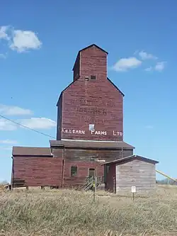 Killean Farms Ltd. grain elevator in Shonts | |
|
Logo | |
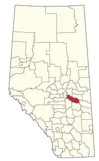 Location within Alberta | |
| Coordinates: 53°15′N 112°14′W | |
| Country | Canada |
| Province | Alberta |
| Region | Central Alberta |
| Census division | 10 |
| Established | 1943 |
| Incorporated | 1958 |
| Government | |
| • Reeve | Kevin Smook |
| • Governing body | Beaver County Council
|
| • CAO | Kayleena Spiess |
| • Administrative office | Ryley |
| Area (2021)[2] | |
| • Land | 3,219.74 km2 (1,243.15 sq mi) |
| Population (2021)[2] | |
| • Total | 5,868 |
| • Density | 1.8/km2 (5/sq mi) |
| Time zone | UTC-7 (MST) |
| • Summer (DST) | UTC-6 (MDT) |
| Postal code span | |
| Website | beaver.ab.ca |
Beaver County was incorporated as a municipal district on July 31, 1999, and the name was changed from "County of Beaver No. 9" to "Beaver County".[3]
Geography
Communities and localities
|
The following urban municipalities are surrounded by Beaver County.[4]
|
The following hamlets are located within Beaver County.[4]
|
The following localities are located within Beaver County.[5]
- Localities
|
|
- Lakes located within Beaver County
Demographics
In the 2021 Census of Population conducted by Statistics Canada, Beaver County had a population of 5,868 living in 2,180 of its 2,434 total private dwellings, a change of -0.6% from its 2016 population of 5,905. With a land area of 3,219.74 km2 (1,243.15 sq mi), it had a population density of 1.8/km2 (4.7/sq mi) in 2021.[2]
In the 2016 Census of Population conducted by Statistics Canada, Beaver County had a population of 5,905 living in 2,177 of its 2,381 total private dwellings, a 3.8% change from its 2011 population of 5,689. With a land area of 3,317.57 km2 (1,280.92 sq mi), it had a population density of 1.8/km2 (4.6/sq mi) in 2016.[6]
Attractions
Two parks with campgrounds are located in the county's limits, Black Nugget Lake (located between Tofield and Ryley, south of Highway 14) and Camp Lake (located east of Viking, between Kinsella and Innisfree).
References
- "Municipal Officials Search". Alberta Municipal Affairs. May 9, 2019. Retrieved October 1, 2021.
- "Population and dwelling counts: Canada, provinces and territories, and census subdivisions (municipalities)". Statistics Canada. February 9, 2022. Retrieved February 9, 2022.
- Beaver County municipal profile Archived 2018-09-02 at the Wayback Machine - Alberta Municipal Affairs
- "Specialized and Rural Municipalities and Their Communities" (PDF). Alberta Municipal Affairs. January 12, 2022. Retrieved January 21, 2022.
- "Standard Geographical Classification (SGC) 2006, Economic Regions: 4810016 - Beaver County, geographical codes and localities, 2006". Statistics Canada. March 5, 2010. Archived from the original on May 25, 2013. Retrieved August 11, 2012.
- "Population and dwelling counts, for Canada, provinces and territories, and census subdivisions (municipalities), 2016 and 2011 censuses – 100% data (Alberta)". Statistics Canada. February 8, 2017. Retrieved February 8, 2017.
External links
Places adjacent to Beaver County, Alberta | |
|---|---|