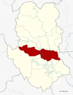
Si Samrong district
Si Samrong (Thai: ศรีสำโรง, pronounced [sǐː sǎm.rōːŋ]) is a district (amphoe) of Sukhothai Province in the lower north of Thailand.[1][2]
Si Samrong
ศรีสำโรง | |
|---|---|
 District location in Sukhothai province | |
| Coordinates: 17°9′53″N 99°51′43″E | |
| Country | Thailand |
| Province | Sukhothai |
| Seat | Khlong Tan |
| Area | |
| • Total | 565.7 km2 (218.4 sq mi) |
| Population (2005) | |
| • Total | 73,810 |
| • Density | 130.5/km2 (338/sq mi) |
| Time zone | UTC+7 (ICT) |
| Postal code | 64120 |
| Geocode | 6406 |
Geography
Neighboring districts are (clockwise from the south) Mueang Sukhothai, Ban Dan Lan Hoi, Thung Saliam, and Sawankhalok of Sukhothai Province and Phrom Phiram of Phitsanulok province.
Its important water resource is the Yom River.
History
The district was renamed from Khlong Tan to Si Samrong in 1939.[3]
Administration
The district is divided into 13 sub-districts (tambons), which are further subdivided into 137 villages (mubans). The township (thesaban tambon) Si Samrong covers tambon Wang Luek and parts of tambons Khlong Tan and Sam Ruean. There are a further 12 tambon administrative organizations (TAO).
| No. | Name | Thai name | Villages | Pop. | |
|---|---|---|---|---|---|
| 1. | Khlong Tan | คลองตาล | 8 | 7,638 | |
| 2. | Wang Luek | วังลึก | 8 | 4,906 | |
| 2. | Wang Luek | วังลึก | 8 | 764 | |
| 3. | Sam Ruean | สามเรือน | 11 | 7,412 | |
| 4. | Ban Na | บ้านนา | 10 | 2,640 | |
| 5. | Wang Thong | วังทอง | 8 | 4,263 | |
| 6. | Na Khun Krai | นาขุนไกร | 12 | 6,749 | |
| 7. | Ko Ta Liang | เกาะตาเลี้ยง | 14 | 7,369 | |
| 8. | Wat Ko | วัดเกาะ | 11 | 5,031 | |
| 9. | Ban Rai | บ้านไร่ | 10 | 5,532 | |
| 10. | Thap Phueng | ทับผึ้ง | 11 | 9,257 | |
| 11. | Ban San | บ้านซ่าน | 10 | 4,149 | |
| 12. | Wang Yai | วังใหญ่ | 8 | 3,771 | |
| 13. | Rao Ton Chan | ราวต้นจันทร์ | 8 | 4,329 |
References
- http://www.sukhothai.go.th/3584/data/data_01.htm
- "Tourism Investment Geo-Informatic Systems - Tourism Investment Geo-Informatic Systems". tourisminvest.tat.or.th. Archived from the original on 30 March 2016. Retrieved 22 May 2022.
- พระราชกฤษฎีกาเปลี่ยนนามอำเภอ กิ่งอำเภอ และตำบลบางแห่ง พุทธศักราช ๒๔๘๒ (PDF). Royal Gazette (in Thai). 56 (ก): 354–364. April 17, 1939. Archived from the original (PDF) on February 19, 2009.
This article is issued from Wikipedia. The text is licensed under Creative Commons - Attribution - Sharealike. Additional terms may apply for the media files.
.svg.png.webp)