Pajarito Mountains (Nayarit)
The Pajarito Mountains (Sierra Pajaritos[2]) are a small mountain range at the southern end of the Sierra Madre Occidental. They are located in the state of Nayarit in western Mexico.
| Pajarito Mountains | |
|---|---|
| |
| Highest point | |
| Elevation | 2,500 m (8,200 ft)[1] |
| Coordinates | 21°57′22″N 104°2′52″W |
| Naming | |
| Native name | Sierra Pajaritos (Spanish) |
| Geography | |
| Country | Mexico |
| State | Nayarit |
| Region | western Mexico |
| Range coordinates | 21°44′59″N 104°15′25″W |
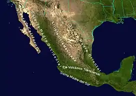
| Parent range | Sierra Madre Occidental |
| Topo map | NF13-08 |
| Geology | |
| Orogeny | Laramide |
| Type of rock | Volcanic |
Geography
The Pajaritos are bounded on the west by the valley of the Huajimic,[3] and on the east by the valley of the Camotlán River.[4] The range consists of tilted blocks with escarpments on their western sides and more gently sloped erosional surfaces on the eastern sides.[4] To the north the Pajaritos are bounded by the Atengo River, and to the south by a major ENE–WSW left-lateral strike-slip fault, and the Santiago River.[5]
Geology
The Pajarito Mountains consist of Cenozoic intrusive granites and granodiorites overlain by late Oligocene and Miocene (23–14 myo) volcanics mainly silicic (rhyolites grading into andesites) and followed (12–8 myo) by surface basalts (lava) and intruding basaltic dikes.[5]
Notes and references
- Gómez-Reyes, Eugenio; et al. (2015). "Water balance of La Yesca municipality, Nayarit, México / El balance hídrico en el municipio de La Yesca, Nayarit, México" (PDF). Revista Bio Ciencias. 3 (3): 228–246. doi:10.15741/revbio.03.03.09.
- Sierra Pajaritos (Unverified - D) at GEOnet Names Server, United States National Geospatial-Intelligence Agency
- Arroyo Huajimic (Approved - N) at GEOnet Names Server, United States National Geospatial-Intelligence Agency
- Barrera R., Rosier Omar (2002). "Consideraciones geomorfologías sobre la Sierra Madre Occidental en el norte de Jalisco, México / Geomorphological considerations about the Sierra Madre Occidental in Northern Jalisco, México" (PDF). Investigaciones geográficas (48): 44–75, page 56. Archived (PDF) from the original on 1 September 2017.
- Nieto-Samaniego, Ángel F.; et al. (1999). "Variation of Cenozoic extension and volcanism across the southern Sierra Madre Occidental volcanic province, Mexico" (PDF). Geological Society of America Bulletin. 111 (3): 347–363. doi:10.1130/0016-7606(1999)111<0347:VOCEAV>2.3.CO;2.