Siha District, Kilimanjaro
Siha is one of the seven administrative districts of Kilimanjaro Region in Tanzania.[1] The district covers approximately 1,217 square kilometres (470 sq mi).[2] It is bordered to the west by Meru District in Arusha Region and to the northeast by Rombo District and the southeast Hai District. The western part of Mount Kilimanjaro is located within the district's boundaries.
Siha
| |
|---|---|
| Wilaya ya Siha, Mkoa wa Kilimanjaro | |
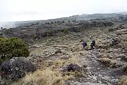 Shira Plateau, Siha District | |
| Nickname: West Kili | |
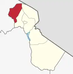 Siha District in Kilimanjaro Region 2022 | |
| Coordinates: 03°11′11″S 37°04′07″E | |
| Country | Tanzania |
| Region | Kilimanjaro Region |
| Capital | Sanya Juu |
| Area | |
| • Total | 1,217 km2 (470 sq mi) |
| Highest elevation (Klute Peak, Shira Plateau, Mount Kilimanjaro) | 3,952 m (12,966 ft) |
| Population (2012) | |
| • Total | 116,131 |
| • Density | 95/km2 (250/sq mi) |
| Demonym | Sihan |
| Ethnic groups | |
| • Settler | Swahili |
| • Native | Chaga |
| Tanzanian Postal Code | 25-4 |
| Website | District website |
According to the 2012 Tanzania National Census, the population of Siha District was 116,313.[3]
Administrative subdivisions
As of 2012, Siha District was administratively divided into 12 wards.[3]
References
- Tanzania: Arusha, Tanga, Kilimanjaro Get Three New Districts
- "Tanzania: Northern Tanzania (Districts and Wards) - Population Statistics, Charts and Map".
- "Census 2012". National Bureau of Statistics. Archived from the original on 5 March 2016. Retrieved 20 April 2016.
This article is issued from Wikipedia. The text is licensed under Creative Commons - Attribution - Sharealike. Additional terms may apply for the media files.