Sixteenth Street Heights
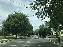
Sixteenth Street Heights is a large neighborhood of rowhouses, duplexes, and American Craftsman and American Foursquare detached houses in Northwest Washington, D.C.

Geography

Definitions of Sixteenth Street Heights' boundaries vary, although the neighborhood can be broadly outlined by 16th Street on the west, Georgia Avenue on the east, Missouri Avenue to the north, and Arkansas Avenue to the south.[1] The 16th Street Heights Tax Assessment Neighborhood is defined as 16th Street on the west, Missouri Avenue on the north, Georgia Avenue on the east, and Upshur Street on the south.[2][3] However, it is also common to view Kennedy Street or Longfellow Street as the northern border of 16th Street Heights. All of 16th Street Heights lies within ZIP code 20011.
Adjoining neighborhoods include:
- Brightwood (north of Missouri Avenue)
- Brightwood Park (northeast of Georgia Avenue and Kennedy Street)
- Columbia Heights (south of Spring Road)
- Crestwood (west of 16th Street)
- Park View (southeast of New Hampshire Avenue)
- Petworth (east of Georgia Avenue)
Transportation
- S1, S2, S4 and S9 Metrobus lines run north-south along 16th Street.
- 52, 54, and 59 Metrobus lines run north-south along 14th Street.
- 70 and 79 Metrobus lines run north-south along Georgia Avenue.
- E2, E3, and E4 Metrobus lines run along Military Road west of 14th Street, north-south along 14th Street, and along Kennedy Street west of 14th Street.
Culture

Sixteenth Street Heights is one of the most demographically diverse neighborhoods in the city. The homes along 16th Street and its surrounding corridor are primarily owned by affluent residents, while the commercial corridors of 14th Street and Georgia Avenue cater to middle- and lower-middle-class Hispanic and African American customers.
Commercial areas
Unlike the neighboring areas of Brightwood, Columbia Heights, and Petworth, 16th Street Heights has few commercial districts. Aside from a handful of corner shops in other areas of the neighborhood, businesses are confined to Georgia Avenue, 14th Street between Buchanan Street and Decatur Street, and the area surrounding the intersection of 14th Street, Colorado Avenue, and Kennedy Street. The Columbia Heights business district also extends to Shepherd Street in the southern end of the neighborhood. Many residents drive elsewhere for most of their shopping.[1]
The 14th and Colorado area was once home to Colorado Kitchen,[4] and Twins Lounge, a notable jazz club. Both have closed.[5]
Churches
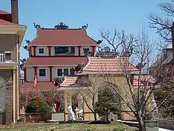
More than 45 churches line 16th Street between Silver Spring, Maryland, and Lafayette Square. In 2008, the LDS Church bought a convent on 1.5 acres (6,100 m2) at the corner of 16th Street and Emerson Street and demolished it. They sought to build a meetinghouse on the site with a 105-foot (32 m) steeple. Neighborhood outcry was fierce; many residents displayed lawn signs that read, "Too Big, Too Much, Too Many." Opponents of the church sought to extend southward the Sixteenth Street Heights overlay zone,[6] which is divided into SSH-1 from Military Road to Colorado Avenue and SSH-2 from Colorado to Decatur.[7] Both restrict non-residential uses and associated parking by requiring Board of Zoning Adjustment approval.[3][8] After much discussion, approval was granted to build the church, which was completed in October 2012 and is now home to two Mormon congregations: the Washington, DC, 3rd Ward and the Mount Pleasant Spanish-speaking Branch.
Recreation
Sixteenth Street Heights is next to Rock Creek Park, a 1,754-acre (7.1 km2) national park that bisects the District of Columbia. Park facilities near 16th Street Heights include the Carter Barron Amphitheater and the William H.G. Fitzgerald Tennis Center, which is the home of the Citi Open tournament (formerly, Legg Mason Tennis Classic).[9]
The Hamilton Recreation Center at 1340 Hamilton Street has a 60-foot (18 m) by 40-foot (12 m) athletic field, a basketball court, a playground, and a small multi-purpose room.[10] The Upshur Recreation Center at 4300 Arkansas Avenue has a baseball/softball field, two basketball courts, a computer lab, a kitchen, a medium-sized multi-purpose room, a playground, and a swimming pool.[11] The Twin Oaks Community Garden, at 1425 Taylor Street, has 40 plots and hosts a Junior Master Gardener Program.[12][13][14]
History
A part of Washington County until passage of the District of Columbia Organic Act of 1871, Sixteenth Street Heights was developed as a series of subdivisions.
Streetcar lines on 14th Street and Georgia Avenue accelerated the growth of the area. The 14th Street line, which originally stopped at Park Road, was extended in late 1906 to spur growth in the area.[15][16] Two historic streetcar facilities are currently used by Metrobus: the Capital Traction Company car barn at 4615 14th Street, NW, is now the Northern Division garage, and the 14th and Colorado turnaround is the terminal for some 52, 53, and 54 buses.
The initial generation of residents was largely white and Jewish. In the 1960s, the neighborhood became mostly African-American.[1][17]
In the 21st century, Sixteenth Street Heights has seen a tremendous transformation. Houses on every street are being renovated inside and out.[1] Many young families have moved in because homes in Sixteenth Street Heights tend to be more affordable than similar ones in many other neighborhoods in DC and close-in suburbs. They are also attracted by the diverse housing stock and the proximity to Carter Barron Amphitheater and Rock Creek Park.
Saul's Addition
Much of 16th Street Heights was once part of Maple Grove Farm, an 80-acre (320,000 m2) nursery acquired in May 1854 by John Hennessy Saul, who led improvements of the Mall, Capitol, and White House grounds.[18] By 1892, Saul's son, Bernard Francis Saul, founded the B.F. Saul Company to sell land in individual lots and take notes as mortgages to speed the sale.[19]
The subdivision known as Saul's Addition was generally bounded by Buchanan Street, Piney Branch Road, Gallatin Street, and Georgia Avenue. Two public buildings were planned: the John Dickson Home for Aged Men (now occupied by the LAMB Public Charter School) and West Elementary School (which has been replaced by a modern building on the same site).[15]
Numerous restrictions were put in the deeds of Saul's Addition lots. Some, including the requirement that all homes be fully detached and the prohibition of commercial and multifamily buildings, remain largely in effect through zoning laws. Others have been dropped or ruled illegal, such as the restriction on the sale of lots to people of color, which was struck down in 1948 by the Supreme Court in Shelley v. Kraemer.[20]
Fourteenth Street Terrace
The area to the north of Saul's Addition was subdivided as Fourteenth Street Terrace. While similar to Saul's Addition, the deeds did not prohibit semi-detached houses, and many duplexes can be seen on the 1300 blocks of Gallatin, Hamilton, and Ingraham Streets.[15]
Politics
Sixteenth Street Heights is represented as part of Ward 4 on the Council of the District of Columbia. Muriel Bowser served as councilperson before she became the city's mayor in 2015. Janeese Lewis George is the current Ward 4 councilperson. Most of Sixteenth Street Heights lies within Advisory Neighborhood Commission 4C.
Three neighborhood organizations serve 16th Street Heights: the 16th Street Heights Civic Association; the 16th Street Neighborhood Association; and the Carter Barron East Neighborhood Association, whose boundaries are Decatur Street to the south, Longfellow Street to the north and 13th Street to the east.[1] The community is also served by the Friends Of The 16th Street Heights Parks.
Former Chancellor of District of Columbia Public Schools Michelle Rhee used to live in the neighborhood.[21]
References
- Gebhardt, Sara (2 February 2008). "Hazy on Borders, Residents Are Sure of 16th Street Heights". The Washington Post. Retrieved 31 December 2008.
- "DC Citizens Atlas". Archived from the original on 3 February 2016. Retrieved 19 March 2012.
- "DC Citizen Atlas". Government of the District of Columbia. Retrieved 31 December 2008.
- Bhattarai, Abha. "Washington Post Colorado Kitchen". Washingtonpost.com. Retrieved 2019-06-20.
- DCist: Curtains for Colorado Kitchen Archived 2008-07-06 at the Wayback Machine
- Schwartzman, Paul (24 May 2008). "Full Up, Fed Up On God's Avenue". The Washington Post. Retrieved 31 December 2008.
- District of Columbia Municipal Regulations 11-1551
- District of Columbia Office of Zoning (7 July 2006). "Summary of Overlay Districts". Retrieved 1 January 2009.
- Clarke, Liz (April 24, 2012). "Other Sports". The Washington Post. Retrieved 9 August 2012.
- D.C. Department of Parks and Recreation. "Hamilton Recreation Center". Department of Parks and Recreation: Recreation Centers. Archived from the original on September 23, 2006. Retrieved 1 January 2009.
- D.C. Department of Parks and Recreation. "Upshur Recreation Center". Department of Parks and Recreation: Recreation Centers. Archived from the original on September 23, 2006. Retrieved 1 January 2009.
- Lara, Kat & Liz, The Garden Cyclers (25 June 2007). "DC's First Annual Community Garden Bicycle Hop". DC Urban Gardener News. D.C. Urban Gardener Association. Archived from the original on 10 October 2008. Retrieved 1 January 2009.
- Greene, Moses Alexander (30 May 2008). "DPR Celebrates Summer Gardening - Community Garden Kick-Off This Saturday and Community Garden Plots Available for Reservation". D.C. Department of Parks and Recreation. Retrieved 1 January 2009.
- Bruske, Ed (12 April 2008). "Approved D.C. Master Gardener Projects". DC Urban Gardener News. D.C. Urban Gardener Association. Archived from the original on 23 April 2008. Retrieved 1 January 2009.
- "Saul's Addition Snug Little City". The Washington Times. 19 November 1910. p. 12.
- "150 New Dwellings in Saul's Addition". The Washington Times. 17 April 1909. p. 13.
- Sadler, Aaron (15 June 2008). "Street named for state has its own distinct flavor". Arkansas News. Stephens Media. Retrieved 31 December 2008.
- "Saul, John (1819-1897)". Biographies of American Seedsmen and Nurserymen. Smithsonian Institution Libraries. 29 August 2001. Retrieved 31 December 2008.
- B.F. Saul Company. "B.F. Saul Company History". Retrieved 31 December 2008.
- "District of Columbia Appropriation Bill, 1917", District of Columbia Appropriation Bill, 1917: Hearings...64th Congress, 1st Session, on H.R. 1574 a Bill Making Appropriations to Provide for the Government of the District of Columbia for the Fiscal Year Ending June 30, 1917, and for Other Purposes, Hearings before the Subcommittee of the Committee on Appropriations, United States Senate, Sixty-fourth Congress, first session, Washington, D.C.: Government Printing Office, 1916
- Glover, Mary Clare (February 1, 2008). "Chancellor Rhee Buys $850,000 Madison Street Victorian". Washingtonian.