Sousse Governorate
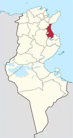
Sousse Governorate (Arabic: ولاية سوسة Wilāyat Sūsah pronounced [ˈsuː.sə]; French: Gouvernorat de Sousse) is one of the twenty-four governorates (provinces) of Tunisia. It is beside the eastern coast of Tunisia in the north-east of the country and covers an area of 2,621 km2 and has a population of 674,971 (2014 census).[1] The capital is Sousse.
Sousse
ولاية سوسة | |
|---|---|
 Map of Tunisia with Sousse highlighted | |
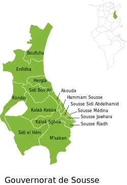
 Subdivisions of Sousse Governorate | |
| Coordinates: 35°50′N 10°38′E | |
| Country | |
| Created | 21 June 1956 |
| Capital | Sousse |
| Government | |
| • Governor | Nabil Ferjani (since 2022) |
| Area | |
| • Total | 2,669 km2 (1,031 sq mi) |
| • Rank | Ranked 19th of 24 |
| Population (2014) | |
| • Total | 674,971 |
| • Rank | Ranked 4th of 24 |
| • Density | 250/km2 (650/sq mi) |
| Time zone | UTC+01 (CET) |
| Postal prefix | xx |
| ISO 3166 code | TN-51 |
Geography
The area compasses most of the broad eastern coastal plain (which has a hot Mediterranean climate) featuring salt and fresh water lakes, fed by winter rains. A narrow strip of forest, the Foret Nationale de Tunisie, adjoins part of the beach swathe between Sousse and Hammamet to the far north, the beach forming most of the coastline. These cities are on the Gulf of Hammamet which is a gently-curved bay. The largest lake is the Sebkhet de Sidi El Hani which is shared with two other areas but is mostly in the Sousse Governorate.[2]
Elevations are pronounced in the second national park in the area, which is mainly in Nabeul Governorate, is on all of the seaward sides of Hammam Bent Djadidi adjoining the northern border.
Transport
Linked by the widest road in the country and railways to Tunis, the area has roads and railways leading further into the country and towards Libya as well as an airport beside the main port city of Sousse, Monastir Habib Bourguiba International Airport which is beyond its short eastern border in much smaller Monastir Governorate. There is a Metro line that goes from Sousse Beb Djedid threw Monastir to Mahdia.
Administrative divisions
The governorate is divided into sixteen delegations (mutamadiyat), listed below with their populations at the 2004 and 2014 Censuses:[3]
| Delegation | Area in km2 | Pop'n 2004 Census | Pop'n 2014 Census |
|---|---|---|---|
| Akouda | 44.6 | 25,717 | 34,494 |
| Bouficha | 261.8 | 23,581 | 26,760 |
| Enfidha | 369.8 | 43,426 | 49,335 |
| Hammam Sousse | 18.5 | 34,685 | 42,691 |
| Hergla | 84.4 | 7,913 | 9,343 |
| Kalâa Kebira | 232.9 | 51,196 | 59,132 |
| Kalâa Seghira | 102.9 | 27,726 | 37,797 |
| Kondar | 173.7 | 11,636 | 13,565 |
| M'saken | 332.5 | 85,380 | 97,225 |
| Sidi Bou Ali | 128.7 | 17,606 | 19,543 |
| Sidi El Hani | 318.7 | 11,614 | 13,505 |
| Sousse Jawhara | 14.3 | 62,663 | 86,517 |
| Sousse Médina | 6.3 | 29,680 | 35,288 |
| Sousse Riadh | 10.1 | .... | 64,532 |
| Sousse Sidi Abdelhamid | 12.3 | 46,257 | 52,787 |
| Zaouia-Ksiba-Thrayet | 36.5 | .... | 32,304 |
Sixteen municipalities are in Sousse Governorate:
| Code | Municipality | Population (2014)[4] |
|---|---|---|
| 3111 | Sousse | 221,530 |
| 3112 | Ksibet Thrayet | 11,623 |
| 3113 | Ezzouhour | 17,348 |
| 3114 | Zaouiet Sousse | 20,681 |
| 3115 | Hammam Sousse | 42,937 |
| 3116 | Akouda | 27,200 |
| 3117 | Kalâa Kebira | 53,323 |
| 3118 | Sidi Bou Ali | 10,282 |
| 3119 | Hergla | 7,419 |
| 3120 | Enfidha | 10,990 |
| 3121 | Bouficha | 9,931 |
| 3122 | Sidi El Hani | 2,706 |
| 3123 | M'saken | 60,165 |
| 3124 | Kalâa Seghira | 34,548 |
| 3125 | Messaadine | 12,916 |
| 3126 | Kondar | 3,804 |
References
- (in French) Census 2014 (National Institute of Statistics) Archived 2014-10-29 at the Wayback Machine
- Physical Map of Tunisia
- Institut National de la Statistique Tunisie (web).
- Recensement Général de la Population et de l'Habitat 2014 – Population, logements et ménages par commune et arrondissement [Census 2014 results – population, accommodation and households per municipality and delegation] (Report) (in French). National Institute of Statistics. 1 April 2015. Retrieved 18 February 2016.