South Carolina Highway 49
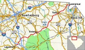
South Carolina Highway 49 (SC 49) is a 79.516-mile (127.969 km) primary state highway in the U.S. state of South Carolina. It is signed as a north–south highway, though it travels in a southwesterly–northeasterly direction, from Watts Mills to the North Carolina state line in Lake Wylie.
South Carolina Highway 49 | ||||
|---|---|---|---|---|
 | ||||
| Route information | ||||
| Maintained by SCDOT | ||||
| Length | 79.516 mi[1][2][3][4][5] (127.969 km) | |||
| Existed | 1937–present | |||
| Tourist routes | ||||
| Major junctions | ||||
| South end | ||||
| ||||
| North end | ||||
| Location | ||||
| Country | United States | |||
| State | South Carolina | |||
| Counties | Laurens, Spartanburg, Union, Chester, York | |||
| Highway system | ||||
| ||||
Route description

SC 49 is part of a three-state highway 49 (including North Carolina Highway 49 and Virginia State Route 49) that totals 325 miles (523 km) from Watts Mills, South Carolina to Crewe, Virginia.[6]
The portion in South Carolina runs 79+1⁄2 miles (127.9 km) from Watts Mills to Lake Wylie.[7]
History
Established in 1937 as a renumbering of SC 163, it traveled from U.S. Route 321 (US 321) in York to the North Carolina state line in Lake Wylie. In 1956, SC 49 was extended southwest to its current southern terminus at US 221 in Watts Mills replacing SC 91 from York to Monarch, SC 92 from Monarch to Cross Anchor, and SC 30 from Cross Anchor to Watts Mills.[8]
In 1960 or 1961, SC 49 was rerouted from Lockhart to Mount Tabor. At an unknown date, SC 49 was rerouted north around downtown Union.[8]
One previous SC 49 existed from around 1927–1935, from Myrtle Beach to the North Carolina state line in Little River. In 1932, most of SC 49 north of Myrtle Beach was replaced by US 117; by 1935, the rest of SC 49 (and US 117) was replaced by US 17.[8]
Major intersections
| County | Location | mi[1][2][3][4][5] | km | Destinations | Notes |
|---|---|---|---|---|---|
| Laurens | Watts Mills | 0.000 | 0.000 | Southern terminus | |
| | 2.530 | 4.072 | I-385 exit 5 | ||
| | 4.840 | 7.789 | |||
| Spartanburg | | 9.353 | 15.052 | I-26 exit 44 | |
| | 10.400 | 16.737 | Eastern terminus of SC 92 | ||
| Cross Anchor | 12.590 | 20.262 | |||
| Union | Union | 27.750 | 44.659 | Western terminus of SC 496 and southern terminus of SC 49 Truck | |
| 28.430 | 45.754 | South end of US 176/SC 215 overlap and northern terminus of SC 49 Truck | |||
| 29.180 | 46.961 | Northern end of US 176 and SC 215 overlap | |||
| 29.970 | 48.232 | ||||
| Monarch Mill | 32.090 | 51.644 | Northern terminus of SC 49 Connector | ||
| | 39.010 | 62.781 | Southern terminus of SC 105 | ||
| Lockhart | 41.540 | 66.852 | Southern end of SC 9 overlap | ||
| Chester | | 42.250 | 67.995 | Northern end of SC 9 overlap | |
| York | Bullock Creek | 47.480 | 76.412 | Western terminus of SC 322 | |
| | 50.550 | 81.352 | |||
| Sharon | 55.940 | 90.027 | Southern terminus of SC 211 | ||
| York | 61.940 | 99.683 | |||
| 62.310 | 100.278 | Southern end of US 321 Bus. overlap | |||
| 62.830 | 101.115 | ||||
| 63.210 | 101.727 | Northern end of US 321 Bus. overlap | |||
| 64.826 | 104.327 | ||||
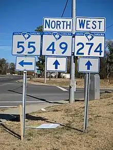
| | 74.146 | 119.326 | Southern end of SC 274 overlap | ||
| | 74.346 | 119.648 | Eastern terminus of SC 55 | ||
| Lake Wylie | 76.396 | 122.947 | Northern end of SC 274 overlap; eastern terminus of SC 557 | ||
| Catawba River / Lake Wylie | 79.516 | 127.969 | Northern terminus | ||
| Buster Boyd Bridge; South Carolina–North Carolina state line | |||||
1.000 mi = 1.609 km; 1.000 km = 0.621 mi
| |||||
Special routes
Union truck route
South Carolina Highway 49 Truck | |
|---|---|
| Location | Union, South Carolina |
| Length | 1.790 mi[9][10] (2.881 km) |
South Carolina Highway 49 Truck (SC 49 Truck) is a 1.790-mile (2.881 km) truck route that bypasses a portion of West Main Street (SC 49) in western portions of Union. The first 0.760 miles (1.223 km) of the highway travels along the two-lane Industrial Park Road, concurrent with the unsigned designation of SC 496. It then turns to the north-northwest along US 176/SC 18 Truck/SC 215 (Duncan Bypass) for its last 1.030 miles (1.658 km).[11]
The entire route is in Union, Union County.
| mi[9][10] | km | Destinations | Notes | ||
|---|---|---|---|---|---|
| 0.000 | 0.000 | Western end of SC 496 concurrency; western terminus of SC 49 Truck and SC 496 | |||
| 0.770 | 1.239 | Duncan Bypass south (US 176 east / SC 18 Truck south / SC 215 south) / Main Street east (SC 496 east) | Eastern end of SC 496 concurrency; western end of US 176/SC 18 Truck/SC 215 concurrency | ||
| 1.790 | 2.881 | Eastern end of US 176/SC 18 Truck/SC 215 concurrency; eastern terminus; provides access to Union Medical Center | |||
1.000 mi = 1.609 km; 1.000 km = 0.621 mi
| |||||
Monarch Mill connector route
South Carolina Highway 49 Connector | |
|---|---|
| Location | Monarch Mill, South Carolina |
| Length | 3.090 mi[12] (4.973 km) |
South Carolina Highway 49 Connector (SC 49 Conn.) is a 3.090-mile-long (4.973 km) connector route along Monarch Highway between SC 215 southeast of Union to SC 49 in the census-designated place of Monarch Mill.[13]
See also
References
- "Highway Logmile Report". South Carolina Department of Transportation. Retrieved December 23, 2020.
- "Highway Logmile Report". South Carolina Department of Transportation. Retrieved December 23, 2020.
- "Highway Logmile Report". South Carolina Department of Transportation. Retrieved December 23, 2020.
- "Highway Logmile Report". South Carolina Department of Transportation. Retrieved December 23, 2020.
- "Highway Logmile Report". South Carolina Department of Transportation. Retrieved December 23, 2020.
- Google (July 4, 2011). "SC,NC,VA 49" (Map). Google Maps. Google. Retrieved July 4, 2011.
- Google (July 4, 2011). "Overview map of SC 49" (Map). Google Maps. Google. Retrieved July 4, 2011.
- "Mapmikey's South Carolina Highways Page". Retrieved July 4, 2011.
- "Highway Logmile Report". South Carolina Department of Transportation. Retrieved December 23, 2020.
- "Highway Logmile Report". South Carolina Department of Transportation. Retrieved December 23, 2020.
- Google (December 23, 2020). "Overview map of SC 49 Truck" (Map). Google Maps. Google. Retrieved December 23, 2020.
- "Highway Logmile Report". South Carolina Department of Transportation. Retrieved December 23, 2020.
- Google (April 15, 2018). "Overview map of SC 49 Conn. (Monarch Mill)" (Map). Google Maps. Google. Retrieved April 15, 2018.
External links
 Media related to South Carolina Highway 49 at Wikimedia Commons
- SC 49 at Virginia Highways' South Carolina Highways Annex
