Hebron Hills
The Hebron Hills, also known as Mount Hebron (Arabic: جبل الخليل, romanized: Jabal al-Khalīl, Hebrew: הר חברון, romanized: Har Hevron), are a mountain ridge, geographic region, and geologic formation, constituting the southern part of the Judean Mountains.[1] The Hebron Hills are located in the southern West Bank.[2][3][4]
| Hebron Hills | |
|---|---|
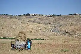 Harvesting in the South Hebron Hills | |
| Highest point | |
| Elevation | 1,026 m (3,366 ft) |
| Prominence | 1,026 m (3,366 ft) |
| Coordinates | 31°26′N 35°0′E |
| Naming | |
| Native name | |
| Geography | |
| Location | West Bank |
| Parent range | Judean Mountains |
Geography
The highest peak of the mountain ridge is in the Palestinian city of Halhul, where a tableland exists with an altitude of 1,026 metres (3,366 ft).
History
Iron Age
The Book of Joshua mentions Maon, Carmel, Adora, and Juttah among others as part of the tribal territory of the Tribe of Judah.[5] The modern Arabic names of Ma'in, al-Karmil, Dura, and Yatta respectively preserve the ancient names.[6][7][8][9]
As the Nabataeans pushed northwards, the Edomites were driven out of old Edom to the south of the Dead Sea and into the southern Hebron Hills between the southern part of the Dead Sea and the Mediterranean, establishing new Edom or Idumaea.[10][11][12]
Hellenistic period
During the Hellenistic period, the Edomites became the dominant population of the southern Hebron Hills.[13] Under Ptolemaic rule, the area became a separate administrative unit known as Idumea, named after its inhabitants. Marisa became its administrative center, with Ziph and Adoraim being of secondary importance.[13]
Hellenistic rule brought Greek and Phoenician culture into Idumea, while the prevalence of male circumcision shows a growing affinity with Judaism.[14]
In 113-112 BCE, the region was captured by the John Hyrcanus, who converted the Edomites to Judaism and incorporated Idumaea into the Hasmonean kingdom.[13][14]
Roman period
The region took part in the Bar Kokhva revolt against the Roman Empire (132-135 CE). The revolt left many settlements in the area destroyed or abandoned, and some of its residents migrated to the Galilee.[13] However, while many areas in Judea proper were depopulated during the revolt and subsequently resettled by foreigners loyal to the Romans, the southern Hebron Hills stood out with its continuing, albeit diminished, Jewish presence.[15] In his Geography, written around 150 CE, Claudius Ptolemy describes Idumea as a desolate area, in contrast to the relative density in the rest of the country north of Idumea to the Galilee.[13]
Late Roman and Byzantine period
During the Late Roman and Byzantine periods, the Hebron Hills were demographically divided into two distinct sub-regions. In the northern part, Christian settlements were established atop the remains of previously destroyed Jewish villages. Meanwhile, the southern Hebron Hills were inhabited by both Jewish and Christian communities.[16] The Jewish population in the southern Hebron Hills appears to have consisted of the descendants of the Jewish residents who remained in the area after the Bar Kokhba revolt, in addition to Jewish migrants from Galilee who joined them. This influx might have occurred during the time of Judah ha-Nasi, who maintained positive relations with the Roman authorities.[15]
During the same period, the southern Hebron Hills became known as Darom or Daroma (Aramaic and Hebrew for "South"). This term appears in rabbinic literature and in Eusebius' Onomasticon.[13][17]
In his Onomasticon, Eusebius mentions seven Jewish settlements that existed in his time in the southern Hebron Hills: Juttah, Carmel, Eshtemoa, Rimmon, Tele, Lower Anim, and Ein Gedi. Archaeological finds confirm the existence of Jewish and Christian settlements in Yatta, al-Karmil, as-Samu, Zif, Maon, Kfar Aziz, Eaton, Gomer, Kishor, Tela, Rimon, and Aristobolia. Jewish settlements were typically built surrounding a synagogue,[16] with the synagogues of Eshtemoa, Maon, Susya and Anim being particularly notable.[1] There is evidence that the region was also inhabited by pagans and Jewish Christians during that period.[13]
Early Islamic period
Following the Muslim conquest of the Levant, the Jewish population in the southern Hebron Hills had been gradually replaced by Muslims. During the early Islamic period, the synagogues of Susya and Eshtemoa were repurposed as mosques.[16] It remains unclear whether local Jews had fled the area or had converted to Islam.
Some Palestinians residing in the Hebron Hills, most notably the Makhamras of Yatta, view themselves as having Jewish ancestry.[18][19][20][21]
Crusader period
During the Crusades, at the time of the Kingdom of Jerusalem, all the Hebron Hills fell under the dominion of the seigneurie of St. Abraham.[22]
1967 and after
In recent times, several areas where traditional Palestinian herding communities live have been declared restricted military zones, forcing the displacement of many families. Several Israeli settlements have been established over the terrain. The Israeli military administration regards the area as a high priority for enforcing demolition orders regarding Palestinian dwellings.[23]
Flora and fauna
The Hebron Hills form the southern and eastern border of Mediterranean vegetation in the region of Palestine.
A 2012 survey by the Israel Nature and Parks Authority discovered 54 rare plant species in the region, more than half of them in cultivated fields. They include Boissiera squarrosa, a type of grass; Legousia hybrida, a plant from the bellflower family; and Reseda globulosa, a rare mignonette.[24]
The region has been known for its vineyards since biblical times. Palestinians and Israelis (from both parts of the Green Line) continue to farm grapes in this region. Local wineries include Yatir Winery.
References
- Werlin, Steven H. (2015). Ancient synagogues of Southern Palestine, 300-800 C.E. : living on the edge. Leiden. ISBN 978-90-04-29840-8. OCLC 918997476.
{{cite book}}: CS1 maint: location missing publisher (link) - Mijal Grinberg (2007-02-14). "Security forces demolish seven houses in Mt. Hebron villages". Haaretz. Archived from the original on 16 February 2007. Retrieved 2014-01-26.
- Europa World Year Book 2. Taylor & Francis Group. 29 July 2004. p. 3308. ISBN 978-1-85743-255-8.
- Dan P.Cole (2015). Lahav V: The Iron, Persian, and Hellenistic Occupation within the Walls at Tell Halif: Excavations in Field II: 1977-1980. Penn State Press. p. 1. ISBN 978-1-57506-366-9.
is strategically located at the juncture of three different ecological zones: the Hebron Hills to the northeast, the foothills of the Shephelah to the west and the Northern Negev Desert to the south
- Joshua 15:1–22
- Abel, F. -M. (1939). "Edward Robinson and the Identification of Biblical Sites". Journal of Biblical Literature. 58 (4): 365–372. doi:10.2307/3259708. ISSN 0021-9231. JSTOR 3259708.
- Conder, CR (1876). "Notes on the Language of the Native Peasantry in Palestine" (PDF). Palestine Exploration Quarterly (Taylor & Francis). Retrieved Mar 25, 2018.
- Robinson and Smith, 1841, vol 2, p. 190
- Conder and Kitchener, 1883, SWP III, p. 312
- Torrey, C. C. (1898). "The Edomites in Southern Judah". Journal of Biblical Literature. 17 (1): 16–20. doi:10.2307/3268802. ISSN 0021-9231. JSTOR 3268802.
Jews. As the Nabataeans, pushed from behind, gradually moved northward, the Edomites were the chief sufferers from their advance; and these in turn, being at length driven out from their old territory, were forced into southern Palestine, of which they finally gained possession; certainly not without a fierce and protracted struggle. The result was a complete shifting of the position of these two peoples; the Nabataeans ultimately occupying old Edom, while the Edomites moved into the region (new Edom, or Idumaea) lying between the southern part of the Dead Sea and the Mediterranean, territory formerly occupied for the most part by the tribe of Judah.
- Danielson, Andrew J. (2021-01-02). "Culinary Traditions in the Borderlands of Judah and Edom during the Late Iron Age". Tel Aviv. 48 (1): 87–111. doi:10.1080/03344355.2021.1904683. ISSN 0334-4355. S2CID 235189577.
- Levin, Yigal (2020-09-24). "The Religion of Idumea and Its Relationship to Early Judaism". Religions. 11 (10): 487. doi:10.3390/rel11100487. ISSN 2077-1444.
- ברוך, יובל (2009). חורבת סוסיה ורוג'ם אל-חמירי כמקרי מבחן להתפתחותו של הכפר והיישוב הכפרי בדרום הר-חברון מן התקופה הרומית הקדומה ועד לתקופה המוסלמית הקדומה [Baruch, Yuval (2009), Horbat Susya and Rujum el-Hamiri as a Case-Study for the Development of the Village and the Rural Settlement in the Southern Hebron Hills from the Early Roman to the Early Muslim Periods] (in Hebrew). Hebrew University of Jerusalem. OCLC 646899358.
- Levin, Yigal (2020-09-24). "The Religion of Idumea and Its Relationship to Early Judaism". Religions. 11 (10): 487. doi:10.3390/rel11100487. ISSN 2077-1444.
- Zissu, Boaz; Klein, Eitan (2013). "Some Remarks on the Jewish Settlement in Judea during the Mishnaic and Talmudic Periods in Light of Funerary Finds". In the Highland's Depth (in Hebrew) (3): 183–184.
- Avni, Gideon (2014). The Byzantine-Islamic transition in Palestine: an archaeological approach. Oxford University Press. pp. 197, 254–255. ISBN 978-0-19-150734-2. OCLC 871044531.
- Chapmann, et al. (2003), p. 72
- "Yatta, Ancient and Modern". The Palestine Post. 21 December 1938. p. 8.
- "The killers of Yatta". The Jerusalem Post | JPost.com. Retrieved 2022-02-16.
- Ben-Zvi, Yitzhak (1967). שאר ישוב: מאמרים ופרקים בדברי ימי הישוב העברי בא"י ובחקר המולדת (in Hebrew). תל אביב תרפ"ז. p. 407.
{{cite book}}: CS1 maint: location missing publisher (link) - "4 Palestinians Claim Descent From Jews Forced to Convert". Haaretz. Retrieved 2022-05-07.
- Claude Reignier Conder, The Latin Kingdom of Jerusalem, (1897) Routledge reprint 2005 ISBN 978-0-710-31080-4 p.78.
- Amira Hass, Hagar Shezaf, 'The Village Where Palestinians Are Rendered Completely Powerless,' Haaretz 5 January 2021
- Zafrir Rinat (15 March 2012). "Treasure trove of rare plants found in Israel's Hebron Hills". Haaretz. Archived from the original on 2012-03-18. Retrieved 26 January 2014.