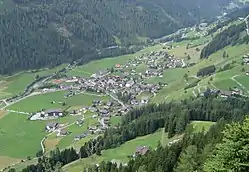
Sankt Jakob in Defereggen
Sankt Jakob in Defereggen (Southern Bavarian: St. Jakoub in Dejfreggin) is a municipality in the district of Lienz in the Austrian state of Tyrol.
St. Jakob in Defereggen
St. Jakoub in Dejfreggin | |
|---|---|
 St Jakob in Defereggen | |
 Coat of arms | |
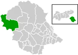 Location within Lienz district | |
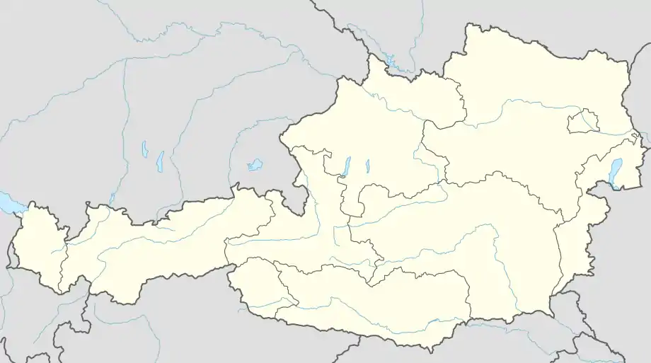 St. Jakob in Defereggen Location within Austria | |
| Coordinates: 46°55′00″N 12°19′00″E | |
| Country | Austria |
| State | Tyrol |
| District | Lienz |
| Government | |
| • Mayor | Ingo Hafele |
| Area | |
| • Total | 186.1 km2 (71.9 sq mi) |
| Elevation | 1,389 m (4,557 ft) |
| Population (2018-01-01)[2] | |
| • Total | 848 |
| • Density | 4.6/km2 (12/sq mi) |
| Time zone | UTC+1 (CET) |
| • Summer (DST) | UTC+2 (CEST) |
| Postal code | 9963 |
| Area code | 04873 |
| Vehicle registration | LZ |
| Website | www.stjakob.at |
Population
| Year | Pop. | ±% |
|---|---|---|
| 1869 | 1,063 | — |
| 1880 | 1,042 | −2.0% |
| 1890 | 946 | −9.2% |
| 1900 | 976 | +3.2% |
| 1910 | 804 | −17.6% |
| 1923 | 765 | −4.9% |
| 1934 | 821 | +7.3% |
| 1939 | 840 | +2.3% |
| 1951 | 914 | +8.8% |
| 1961 | 889 | −2.7% |
| 1971 | 1,020 | +14.7% |
| 1981 | 1,026 | +0.6% |
| 1991 | 1,005 | −2.0% |
| 2001 | 1,009 | +0.4% |
Climate
| Climate data for Sankt Jakob in Defereggen: 1383m (1991−2020 normals) | |||||||||||||
|---|---|---|---|---|---|---|---|---|---|---|---|---|---|
| Month | Jan | Feb | Mar | Apr | May | Jun | Jul | Aug | Sep | Oct | Nov | Dec | Year |
| Record high °C (°F) | 13.7 (56.7) |
14.3 (57.7) |
17.9 (64.2) |
22.0 (71.6) |
26.6 (79.9) |
31.8 (89.2) |
30.5 (86.9) |
30.7 (87.3) |
27.0 (80.6) |
21.4 (70.5) |
19.6 (67.3) |
14.3 (57.7) |
31.8 (89.2) |
| Average high °C (°F) | −1.4 (29.5) |
2.3 (36.1) |
6.6 (43.9) |
10.8 (51.4) |
14.7 (58.5) |
19.2 (66.6) |
20.3 (68.5) |
19.6 (67.3) |
15.7 (60.3) |
10.4 (50.7) |
4.1 (39.4) |
−1.5 (29.3) |
10.1 (50.1) |
| Daily mean °C (°F) | −6.5 (20.3) |
−4.0 (24.8) |
0.7 (33.3) |
4.8 (40.6) |
9.0 (48.2) |
12.5 (54.5) |
14.3 (57.7) |
14.0 (57.2) |
9.9 (49.8) |
5.5 (41.9) |
−0.2 (31.6) |
−5.7 (21.7) |
4.5 (40.1) |
| Average low °C (°F) | −11.5 (11.3) |
−11.2 (11.8) |
−5.4 (22.3) |
−1.6 (29.1) |
2.4 (36.3) |
5.8 (42.4) |
7.3 (45.1) |
7.2 (45.0) |
3.8 (38.8) |
−0.1 (31.8) |
−4.8 (23.4) |
−10.0 (14.0) |
−1.5 (29.3) |
| Record low °C (°F) | −25.1 (−13.2) |
−25.0 (−13.0) |
−25.6 (−14.1) |
−14.5 (5.9) |
−6.8 (19.8) |
−2.8 (27.0) |
−1.3 (29.7) |
−2.0 (28.4) |
−6.3 (20.7) |
−14.4 (6.1) |
−19.4 (−2.9) |
−27.1 (−16.8) |
−27.1 (−16.8) |
| Average precipitation mm (inches) | 33.7 (1.33) |
27.5 (1.08) |
41.7 (1.64) |
56.3 (2.22) |
94.0 (3.70) |
133.4 (5.25) |
149.2 (5.87) |
149.1 (5.87) |
94.7 (3.73) |
91.0 (3.58) |
82.6 (3.25) |
51.4 (2.02) |
1,004.6 (39.54) |
| Average snowfall cm (inches) | 46.1 (18.1) |
45.0 (17.7) |
47.1 (18.5) |
26.0 (10.2) |
3.2 (1.3) |
0.0 (0.0) |
0.0 (0.0) |
0.0 (0.0) |
2.0 (0.8) |
13.1 (5.2) |
46.1 (18.1) |
61.9 (24.4) |
290.5 (114.3) |
| Source: Central Institute for Meteorology and Geodynamics[3] | |||||||||||||
Personalities
- Mario Scheiber, skier
References
- "Dauersiedlungsraum der Gemeinden Politischen Bezirke und Bundesländer - Gebietsstand 1.1.2018". Statistics Austria. Retrieved 10 March 2019.
- "Einwohnerzahl 1.1.2018 nach Gemeinden mit Status, Gebietsstand 1.1.2018". Statistics Austria. Retrieved 9 March 2019.
- "Klimamittelwerte 1991-2020" (in German). Central Institute for Meteorology and Geodynamics. Retrieved 31 August 2023.
External links
- www.stjakob.at - city website
Wikimedia Commons has media related to St. Jakob in Defereggen.
This article is issued from Wikipedia. The text is licensed under Creative Commons - Attribution - Sharealike. Additional terms may apply for the media files.