Dinsdale, New Zealand
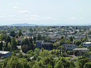
Dinsdale is the westernmost suburb of Hamilton in New Zealand. Originally called Frankton West, it was renamed in July 1961 after Thomas Dinsdale.[3] Dinsdale grew rapidly in the 1960s.[4] It is located around a low ridge with some views westward to open farm land. It has a large sports ground and shopping complex with a supermarket, shops and Dinsdale Library,[5] one of the branches of the Hamilton City Libraries. The community church of West Hamilton is located in the suburb.[6]
Dinsdale | |
|---|---|
 Dinsdale, Hamilton | |
| Coordinates: 37°47′45.42″S 175°14′33.28″E | |
| Country | New Zealand |
| City | Hamilton, New Zealand |
| Local authority | Hamilton City Council |
| Electoral ward | West Ward |
| Established | 1962 |
| Area | |
| • Land | 308 ha (761 acres) |
| Population (June 2022)[2] | |
| • Total | 8,800 |
| Western Heights | Livingstone | Maeroa |
| Whatawhata |
|
Frankton |
| Stonebridge | Ngāhinapōuri | Melville |
Demographics
Dinsdale covers 3.08 km2 (1.19 sq mi)[1] and had an estimated population of 8,800 as of June 2022,[2] with a population density of 2,857 people per km2.
| Year | Pop. | ±% p.a. |
|---|---|---|
| 2006 | 7,548 | — |
| 2013 | 7,764 | +0.40% |
| 2018 | 8,349 | +1.46% |
| Source: [7] | ||
Dinsdale had a population of 8,349 at the 2018 New Zealand census, an increase of 585 people (7.5%) since the 2013 census, and an increase of 801 people (10.6%) since the 2006 census. There were 2,874 households, comprising 4,122 males and 4,230 females, giving a sex ratio of 0.97 males per female, with 1,824 people (21.8%) aged under 15 years, 1,863 (22.3%) aged 15 to 29, 3,606 (43.2%) aged 30 to 64, and 1,053 (12.6%) aged 65 or older.
Ethnicities were 73.0% European/Pākehā, 29.2% Māori, 5.8% Pacific peoples, 9.2% Asian, and 2.4% other ethnicities. People may identify with more than one ethnicity.
The percentage of people born overseas was 15.9, compared with 27.1% nationally.
Although some people chose not to answer the census's question about religious affiliation, 51.5% had no religion, 35.1% were Christian, 1.1% had Māori religious beliefs, 2.2% were Hindu, 0.8% were Muslim, 0.8% were Buddhist and 2.3% had other religions.
Of those at least 15 years old, 1,149 (17.6%) people had a bachelor's or higher degree, and 1,296 (19.9%) people had no formal qualifications. 894 people (13.7%) earned over $70,000 compared to 17.2% nationally. The employment status of those at least 15 was that 3,543 (54.3%) people were employed full-time, 876 (13.4%) were part-time, and 306 (4.7%) were unemployed.[7]
| Name | Area (km2) | Population | Density (per km2) | Households | Median age | Median income |
|---|---|---|---|---|---|---|
| Dinsdale North | 1.52 | 4,383 | 2,884 | 1,476 | 33.0 years | $32,400[8] |
| Dinsdale South | 1.56 | 3,966 | 2,542 | 1,398 | 34.3 years | $35,300[9] |
| New Zealand | 37.4 years | $31,800 |

Education
Aberdeen School is acoeducational contributing primary school (years 1–6) with a roll of 653 students as of April 2023.[10][11] Aberdeen opened in the mid-1970s.[12]
St. Columba's Catholic School is a state-integrated coeducational full primary school (years 1–8) with a roll of 470.[13]
Neighboring surroundings
The Taitua Arboretum may be accessed via Tills Lookout. Hamilton, New Zealand[14][15]
See also
References
- "ArcGIS Web Application". statsnz.maps.arcgis.com. Retrieved 17 October 2022.
- "Population estimate tables - NZ.Stat". Statistics New Zealand. Retrieved 25 October 2022.
- Williams, Lyn (27 September 2018). "History: The dead tell tales". Stuff.
- Dinsdale — Where Town Meets Country.
- "One-day closure for Central Library | Scoop News". www.scoop.co.nz.
- Smallman, Elton (30 July 2015). "Challenge of exile brings church community closer". Stuff.
- "Statistical area 1 dataset for 2018 Census". Statistics New Zealand. March 2020. Dinsdale North (177900) and Dinsdale South (178100).
- 2018 Census place summary: Dinsdale North
- 2018 Census place summary: Dinsdale South
- "New Zealand Schools Directory". New Zealand Ministry of Education. Retrieved 12 December 2022.
- Education Counts: Aberdeen School
- "History of Frankton School". Frankton School. Retrieved 17 October 2020.
- Education Counts: St. Columba's Catholic School
- "Taitua Arboretum". Hamilton City Council. Retrieved 12 February 2020.
- "Taitua Arboretum". The Mighty Waikato (New Zealand). Retrieved 12 February 2020.