Shirley Parish Church
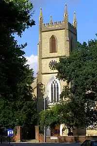
St James' by the Park (sometimes known as Shirley Parish Church) is an Anglican parish church which meets in Shirley, Southampton. Following the closure of St John's church, the church has one church building, the grade II listed St James'.[1]

History

The Domesday Book records a church being present at Shirley in 1085, but on 1 May 1574 the parish of Shirley was amalgamated with that of Millbrook as the small Shirley congregation could not afford the upkeep of the Shirley church building.[2] The Shirley church was demolished in 1609, with stones from the old building used to enlarge St Nicholas' Church building in Millbrook.[2]
By 1836, the population of the combined parish had reached 2,375 inhabitants, and the old Millbrook parish church was too small.[2] Land was donated for a new church building in Shirley by Nathaniel Newman Jefferys,[3] and Church Building Society combined with private funding to pay for the structure itself.[2] The new church, dedicated to St. James, was designed by local architect William Hinves[3] and consecrated on 20 August 1836 by the Bishop of Winchester with a large crowd present despite "unfavourable weather", according to the Hampshire Advertiser newspaper.[2] The newspaper went on to give this description of the new building:
It contains six hundred sittings. At the back of the altar is a gothic screen, divided into three components, the outer entablatures contain the Commandments, the Lord's Prayer and the Belief, the centre entablature the crucifixion by Shayer, a first rate painting, the head of life itself and the expression of subdued anguish is beautifully conceived and awakes the feeling of an intense degree of interest. It is one of the happiest of his late products.[2]
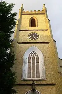
The building was also described in 1848 as "a handsome structure in the later English style, with a square embattled tower".[2]
The first vicar of Shirley was the Reverend William Orger, who looked after the parish for 25 years.[2] During this time, the church grew quickly, to such an extent that the building was added to within a few years of its consecration. Balconies added in 1840 raised the capacity to 1080.[2][4] In 1848, only 432 of these pews were free, implying a regular congregation of around 600.[4] A church clock was provided in 1875,[2] and further new pews and a new chancel were added in 1881.[2]
The parish register for St John's was started in 1912.[5]

Plans to rebuild St John's church were submitted in 1957,[6] with amended plans submitted and approved in 1959.[7] The foundation stone of the new building was laid by the Bishop of Winchester, Dr Alwyn Williams.[8] The building was subsequently adapted into a community centre named St John's Centre.[9]
The interior of the St James' building was renovated in 1994; the pews were removed and the floor levelled and carpeted. On 1 March 2016, they further updated their seating with the addition of new chairs that now blue and are more cushioned than the previous ones.
In 2020 it was reported that St John's Centre could be demolished and replaced with housing[10] and plans were submitted later that year to replace the building with five houses.[11] Permission for those plans was refused[11] and new plans were submitted in 2021 to replace the St John's building with four houses; this planning application was withdrawn in October 2022.[12] The St John's building was sold to the Church of Pentecost and handed over at a joint celebration in early 2023.[13]
References
- Southampton City Council: Listed buildings in Southampton Archived 7 February 2012 at the Wayback Machine Accessed 13 September 2007.
- Shirley from Domesday to D Day. Southampton: Southampton City Council. 1997. ISBN 1-872649-07-6.
- Preston, Richard. "William Hinves and Alfred Bedborough: architects in nineteenth-century Southampton" (PDF). Southampton Local History Forum Journal. Southampton City Council. p. 5. Archived from the original (PDF) on 27 January 2013. Retrieved 22 March 2012.
- 'Shirburn – Shitterton', A Topographical Dictionary of England (1848), pp. 85–7. URL: http://www.british-history.ac.uk/report.asp?compid=51273. Date accessed: 13 September 2007.
- "Southampton parish register dates". Lineone.net. Archived from the original on 27 August 2005. Retrieved 20 September 2017.
- "1102/H | Rebuild church | St John's Church, St James' Road". planningpublicaccess.southampton.gov.uk. Retrieved 31 March 2023.
- "1150/58 | Rebuild church | St John's Church, St James' Road". planningpublicaccess.southampton.gov.uk. Retrieved 31 March 2023.
- "Foundation stone of new Shirley church is laid by bishop" (PDF). The Southern Evening Echo. 14 November 1959.
- "910995/WA | INSTALLATION OF A NON-ILLUMINATED FASCIA SIGN FOR COMMUNITY CENTRE | St. Johns Church St. James Road Southampton - Application form" (PDF). planningpublicaccess.southampton.gov.uk. Retrieved 31 March 2023.
- "Southampton church centre could be demolished to make way for new houses". Daily Echo. Retrieved 31 March 2023.
- "20/00851/OUT | Demolition of the existing St. John's building and redevelopment of the site by the erection of 5 houses with associated access from St. James Road, parking and gardens (Outline application seeking approval for access, layout and scale). | St Johns Church St James Road Southampton SO15 5FB". planningpublicaccess.southampton.gov.uk. Retrieved 31 March 2023.
- "21/00162/OUT | Redevelopment of the site. Erection of 4 semi-detached houses, with associated access from St. James Road, parking and gardens, following demolition of the existing St John's Centre building (Outline application seeking approval for access, layout and scale) (Resubmission 20/00851/OUT) | St Johns Church St James Road Southampton SO15 5FB". planningpublicaccess.southampton.gov.uk. Retrieved 31 March 2023.
- Team, Diocese of Winchester-Communications (2 February 2023). "A joint celebration with the Church of Pentecost to mark historic church handover in Shirley". Diocese of WINCHESTER. Retrieved 31 March 2023.