Standley Chasm
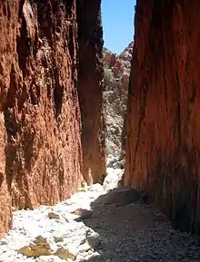
Standley Chasm is a geological formation located west of Alice Springs in the Northern Territory. It lies within the West MacDonnell National Park.[1] The Western Arrernte Aboriginal people are its original owners; it is traditionally known as Angkerle Atwatye, meaning the Gap of Water.[2] Standley Chasm is located in a reserve privately owned by the Iwupataka Land Trust.[3]
| Standley Chasm | |
|---|---|
| Type | Geological Formation |
| Location | |
| Coordinates | 23.722°S 133.470°E |
The first European name for the formation was Gall Springs but it was renamed Standley Chasm in honour of Ida Standley, the first school teacher in Alice Springs.[4][5]
The chasm is generally in shade for most of the day, but changes colour around noon when the sun is directly overhead, making this the most popular time of the day to visit.[6]
References
- "Standley Chasm Angkerle Atwatye". Northern Territory Government. Retrieved 2 December 2018.
- "Standley Chasm ANGKERLE". Standley Chasm. Retrieved 6 July 2018.
- "Standley Chasm ANGKERLE (about)". Standley Chasm. Retrieved 6 July 2018.
- "Place Names Register". www.ntlis.nt.gov.au. Retrieved 26 October 2019.
- Traynor, Stuart (2016). Alice Springs : from singing wire to iconic outback town. Mile End, South Australia. ISBN 9781743054499. OCLC 958933012.
{{cite book}}: CS1 maint: location missing publisher (link) - "Standley Chasm - A complete guide | Travel Guide". A Little Off Track. 1 July 2021. Retrieved 19 April 2022.
This article is issued from Wikipedia. The text is licensed under Creative Commons - Attribution - Sharealike. Additional terms may apply for the media files.