KwaDukuza
KwaDukuza, previously known as Stanger, is a city in KwaZulu-Natal, South Africa. In 2006, the municipal name was changed to KwaDukuza (which incorporates small towns such as Stanger, Balito, and Shaka's Kraal), but the Zulu people in the area called it "Dukuza" well before then.
KwaDukuza
Stanger | |
|---|---|
 KwaDukuza  KwaDukuza | |
| Coordinates: 29°20′00″S 31°17′30″E | |
| Country | South Africa |
| Province | KwaZulu-Natal |
| District | iLembe |
| Municipality | KwaDukuza |
| Established | 1825 as Dukuza, 1873 as Stanger[1] |
| Area | |
| • Total | 32.37 km2 (12.50 sq mi) |
| Population (2011)[2] | |
| • Total | 51,536 |
| • Density | 1,600/km2 (4,100/sq mi) |
| Racial makeup (2011) | |
| • Black African | 53.0% |
| • Coloured | 1.9% |
| • Indian/Asian | 43.7% |
| • White | 0.7% |
| • Other | 0.7% |
| First languages (2011) | |
| • English | 47.7% |
| • Zulu | 46.0% |
| • Xhosa | 1.4% |
| • Other | 4.8% |
| Time zone | UTC+2 (SAST) |
| Postal code (street) | 4449 |
| PO box | 4450 |
The city has been under major economical construction since 2015, having built a multi-million rand regional shopping mall in 2018.[3][4][5]
History
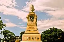
The city was founded about 1820 by King Shaka and was named KwaDukuza (Zulu: Place of the Lost Person) because of the capital's labyrinth of huts. After Shaka was assassinated on 22 September 1828 during a coup by two of his half-brothers, Dingane and Umthlangana (Mhlangane), the city was burnt to the ground. In 1873, European settlers built a town on the site, naming it Stanger after William Stanger, the surveyor-general of Natal.
Stanger became a municipality in 1949 and is the commercial, magisterial and railway centre of an important sugar-producing district. A small museum adjoins the site of Shaka's grave, a grain pit in the city centre. The city and its vibrant inhabitants are surrounded by sugar cane fields, bush and the mahogany tree where Shaka held meetings, which still stands in front of the municipal offices. The Shaka Day festival, a colourful ceremony of 10,000 or more Zulus, is held at the KwaDukuza Recreation Grounds on 24 September every year. The festival is usually attended by dignitaries to mark the significance of the Zulu nation.
In 2006, the Minister of Arts and Culture approved a name change from Stanger to KwaDukuza, which was published in the Government Gazette of South Africa on 3 March 2006.
The KwaDukuza Museum houses historical items and information on Shaka, the sugar industry and local history. The city has a South Asian influence because of the influx of labourers from India in the late 19th and the early 20th centuries for sugarcane barons, such as Liege Hulett. The first few hundred Indian families left Port Natal for the cane farms on 17 November 1860. The importation of Indian labourers was stopped in 1911, when their numbers exceeded 100,000. Most Indians did not return when their work contracts expired, but exchanged their return-trip passes for money or property. The growth of the Indian community changed the economic and cultural nature of the city and has successfully developed it into what it is today. Celebrations include Diwali and the Winter Fair, the latter being a fundraiser for child welfare.
In July, 2021, the city was significantly impacted by large scale looting, vandalism, property damage and civil unrest caused during the 2021 South African unrest, much to the dismay of the Indian population.[6][7][8]
Law and government
KwaDukuza forms part of the KwaDukuza Local Municipality and the larger iLembe District Municipality, serving as the seat for both municipalities. It has a Magistrate's Court and most central and provincial government departments maintain regional branches or other offices in the town.
Geography
Located on the hilly North Coast of KwaZulu-Natal, KwaDukuza lies approximately 73 km (45 mi) north-west of Durban and 106 km (67 mi) south-west of Richards Bay. Morevover, the city is situated 8 kilometres (5 miles) inland from Blythedale Beach on the Mbozamo River.
The nearest settlements to KwaDukuza other than Blythedale Beach include Darnall (12 km), Shakaskraal (16 km), Tinley Manor Beach (18 km), Zinkwazi Beach (21 km) and Ballito (30 km).
Suburban areas[9]
- Dawnside
- Gledhow
- Glen Hills
- High Ridge
- Larkfield
- Northlands
- Shakville
- Stanger Ext 2
- Stanger Ext 3
- Stanger Ext 5
- Stanger Ext 6
- Stanger Ext 7
- Stanger Ext 8
- Stanger Ext 9
- Stanger Ext 10
- Stanger Ext 12
- Stanger Ext 14
- Stanger Ext 15
- Stanger Ext 17
- Stanger Ext 18
- Stanger Ext 19
- Stanger Ext 21
- Stanger Ext 22
- Stanger Ext 24
- Stanger Ext 25
- Stanger Ext 26
- Stanger Ext 27
- Stanger Ext 29
- Stanger Ext 31
- Stanger Ext 32
- Stanger Ext 33
- Stanger Ext 34
- Stanger Ext 35
- Townview
- Warrenton
Climate
The Köppen-Geiger climate classification system classifies the KwaDuzuka climate as humid subtropical (Cfa),[10] with more rain in the summer.
The highest record temperature was 43 °C (109 °F) on February 3, 2008, and the lowest record temperature was 5 °C (41 °F) on June 12, 2013.[11]
| Climate data for KwaDukuza | |||||||||||||
|---|---|---|---|---|---|---|---|---|---|---|---|---|---|
| Month | Jan | Feb | Mar | Apr | May | Jun | Jul | Aug | Sep | Oct | Nov | Dec | Year |
| Record high °C (°F) | 40 (104) |
43 (109) |
41 (106) |
38 (100) |
39 (102) |
37 (99) |
35 (95) |
39 (102) |
43 (109) |
41 (106) |
41 (106) |
41 (106) |
43 (109) |
| Average high °C (°F) | 28.4 (83.1) |
28.7 (83.7) |
28.3 (82.9) |
26.5 (79.7) |
24.8 (76.6) |
23.2 (73.8) |
22.8 (73.0) |
23.8 (74.8) |
24.6 (76.3) |
25.2 (77.4) |
26.2 (79.2) |
27.8 (82.0) |
25.9 (78.5) |
| Daily mean °C (°F) | 24.2 (75.6) |
24.5 (76.1) |
23.9 (75.0) |
21.8 (71.2) |
19.4 (66.9) |
17.3 (63.1) |
16.9 (62.4) |
18.2 (64.8) |
19.6 (67.3) |
20.8 (69.4) |
21.9 (71.4) |
23.5 (74.3) |
21.0 (69.8) |
| Average low °C (°F) | 20.1 (68.2) |
20.4 (68.7) |
19.5 (67.1) |
17.1 (62.8) |
14.1 (57.4) |
11.5 (52.7) |
11.1 (52.0) |
12.6 (54.7) |
14.6 (58.3) |
16.4 (61.5) |
17.7 (63.9) |
19.3 (66.7) |
16.2 (61.2) |
| Record low °C (°F) | 16 (61) |
15 (59) |
15 (59) |
11 (52) |
6 (43) |
5 (41) |
6 (43) |
6 (43) |
5 (41) |
10 (50) |
7 (45) |
14 (57) |
5 (41) |
| Average precipitation mm (inches) | 118 (4.6) |
120 (4.7) |
125 (4.9) |
72 (2.8) |
60 (2.4) |
37 (1.5) |
33 (1.3) |
41 (1.6) |
60 (2.4) |
92 (3.6) |
114 (4.5) |
119 (4.7) |
991 (39) |
| Source 1: Climate-Data.org (altitude: 60m)[10] | |||||||||||||
| Source 2: Voodoo Skies for record temperatures[11] | |||||||||||||
Infrastructure
Healthcare
KwaDukuza has of two major hospitals, General Justice Gizenga Mpanza Regional Hospital, in the city centre which serves as iLembe's largest and main public hospital and the KwaDukuza Private Hospital, on the southern outskirts of the city which was opened in February 2018.[12][13] Other than hospitals, KwaDukuza has three public clinics which fall under the jurisdiction of the General Justice Gizenga Mpanza Regional Hospital, including Glenhills Clinic, to the west of the city, KwaDukuza Clinic, just south of the city centre and the Nandi Clinic, north of the city.[14]
Schools
- Stanger Manor Secondary School
- Stanger Secondary School
- Glenhills Secondary School
- Glenhills Primary School
- Stanger M.L. Sultan Secondary School
- Stanger High School
- Dawnview Primary School
- Zakkariyya Muslim School
- Stanger Primary School
- Stanger Manor Primary School
- Stanger South Secondary School
- Tshelenkosi secondary school
Rail Transport
KwaDukuza is located at the northern end of the North Coast Line, which is served by the commuter rail network, Metrorail KwaZulu-Natal and runs down south to Durban via Groutville, Shakaskraal, Umhlali, oThongathi (Tongaat), Verulam and Mount Edgecombe.
Road Transport
KwaDukuza's three main arterial routes include the N2, R74 and R102. The N2 highway is the main freeway passing KwaDukuza, running from Ballito and Durban in the south-west to Empangeni and Richards Bay in the north-east, with the R74 interchange (Exit 233) providing the main access way from the N2 into KwaDukuza. Alternatively the Groutville interchange (Exit 226), south of KwaDukuza can be used to access the town from the N2. The R74 begins at the interchange with the N2 just east of the city, bypassing the city centre to the north and runs north-westwards to Greytown in the Midlands of KwaZulu-Natal. The extension of the R74 from the N2 interchange is a small secondary road connecting to the coastal village of Blythedale Beach. The R102, running parallel to the N2 highway runs from Shakaskraal and oThongathi in the south-west, bypassing the city centre to the east and runs north-eastwards to KwaGingindlovu and Empangeni.
Notable residents
See also
References
- "KwaDUKUZA / STANGER – A History". sahistory.org. Retrieved 2009-08-31.
- "Main Place KwaDukuza". Census 2011.
- "Store Directory – Kwadukuza Regional Mall".
- "KWADUKUZA MALL CELEBRATES 2ND BIRTHDAY - 5 Star Durban - Showcasing Beautiful KwaZulu-Natal". Archived from the original on 2020-10-26.
- "KwaDukuza Mall's social media success | News24".
- "WATCH | Protesters storm KwaDukuza CBD and Tongaat in KZN | Witness".
- "WATCH: Mass looting across KwaDukuza and Mandeni | North Coast Courier".
- "Fear gripped KwaZulu-Natal residents on Monday night while others partied | Witness".
- "Census 2011: Main Place: Stanger". census2011.adrianfrith.com. Retrieved 2023-03-19.
- "Climate: KwaDukuza - Climate graph, Temperature graph, Climate table". Climate-Data.org. Retrieved 2014-01-17.
- "Stanger, South Africa". Voodoo Skies. Retrieved 2014-01-17.
- "General Justice Gizenga Mpanza Regional Hospital". www.kznhealth.gov.za. Retrieved 2023-03-20.
- "KwaDukuza Private Hospital – Private Healthcare Facility". Retrieved 2023-03-20.
- "Clinics in Ilembe district". www.kznhealth.gov.za. Retrieved 2023-03-20.
Municipalities and communities of ILembe District Municipality, KwaZulu-Natal | ||
|---|---|---|
District seat: Stanger (KwaDukuza) | ||
| Mandeni | .svg.png.webp) ILembe District within South Africa | |
| KwaDukuza | ||
| Ndwedwe | ||
| Maphumulo | ||