Oklahoma State Highway 165
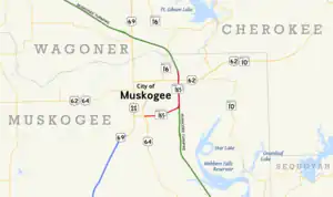
State Highway 165 (SH-165) is a state highway in Muskogee County, Oklahoma. It runs east along Peak Boulevard in the southern part of Muskogee from US-64 to the northern terminus of the southern section of the Muskogee Turnpike, then runs north as a freeway connecting the two sections of the turnpike. The total length of the highway is 8.21 miles (13.21 km).[1]
State Highway 165 | ||||
|---|---|---|---|---|
 | ||||
| Route information | ||||
| Maintained by ODOT | ||||
| Length | 8.21 mi[1] (13.21 km) | |||
| Existed | ca. 1969–present | |||
| Major junctions | ||||
| West end | ||||
| North end | ||||
| Location | ||||
| Country | United States | |||
| State | Oklahoma | |||
| Highway system | ||||
| ||||
| ||||

The freeway connecting the two halves of the Muskogee Turnpike was first numbered as SH-165 in 1969. The east–west portion of highway along Peak Boulevard was built and numbered as SH-165 by 1987.
Route description
SH-165 begins at an interchange on Peak Boulevard on the south side of Muskogee. To the west of this interchange, Peak Boulevard carries US-64; that highway exits from Peak at the interchange and proceeds south towards Warner. This interchange is also the eastern terminus of US-64 Business, which continues to the north towards downtown Muskogee.[1] From the interchange, SH-165 follows Peak Boulevard to the east as an expressway, crossing Coody Creek before turning to the east-northeast.[2] As the highway crosses York Street, it exits the Muskogee city limits.[1]
SH-165 then has an partial interchange with the Muskogee Turnpike; the turnpike is only accessible from southbound SH-165.[3] The Muskogee Turnpike consists of two disconnected sections of toll road with an untolled freeway segment in between; northbound SH-165 traffic merges with the northbound lanes of the turnpike to form this freeway. Shortly after this interchange, the highway re-enters Muskogee.[1] The SH-165 freeway serves the east side of Muskogee, with interchanges with city arterials such as Chandler Road, Hancock Street, and Gibson Street.[2] The highway also includes a full cloverleaf interchange with US-62.[3] SH-165 continues north of US-62 for 0.96 miles (1.54 km) to its final interchange with Hyde Park Road near the Port of Muskogee.[1] At this interchange, SH-165 ends; northbound traffic defaults onto the northbound Muskogee Turnpike towards Tulsa.
History
The freeway between the two sections of the Muskogee Turnpike that would later become SH-165 first appears on the official Oklahoma state map in 1969. The Muskogee inset of that map shows the freeway, unnumbered, and the southern SH-165–turnpike interchange in place, but with ramp stubs, as the SH-165 portion of Peak Boulevard had yet to be built.[4] The following year's map shows SH-165 in place along the connector freeway.[5] By 1975, the Peak Boulevard portion of SH-165 was under construction.[6] The highway was complete and in its present-day configuration by 1987.[7]
Junction list
The entire route is in Muskogee, Muskogee County.
| mi[1][3] | km | Destinations | Notes | ||
|---|---|---|---|---|---|
| 0.00 | 0.00 | ||||
| 0.00 | 0.00 | Western (southern) terminus | |||
| 4.44 | 7.15 | ||||
| 4.44 | 7.15 | Freeway segment begins | |||
| 5.2 | 8.4 | Chandler Road, Hancock Street | |||
| 6.2 | 10.0 | Gibson Street | |||
| 7.25 | 11.67 | ||||
| 7.25 | 11.67 | ||||
| 8.21 | 13.21 | Hyde Park Road – Port of Muskogee, War Memorial Park | Northern (eastern) terminus | ||
| 8.21 | 13.21 | ||||
| 1.000 mi = 1.609 km; 1.000 km = 0.621 mi | |||||
References
- Oklahoma Department of Transportation (n.d.). Control Section Maps: Muskogee County (PDF) (Map) (2010–2011 ed.). Scale not given. Oklahoma City: Oklahoma Department of Transportation. Retrieved August 10, 2012.
- Oklahoma Atlas and Gazetteer (Map). 1:200,000. DeLorme. 2006.
- Google (August 11, 2012). "Oklahoma State Highway 165" (Map). Google Maps. Google. Retrieved August 11, 2012.
- Oklahoma 1970 (PDF) (Map). Oklahoma Department of Highways. Muskogee inset. Retrieved August 13, 2012.
- Oklahoma 1970 (PDF) (Map). Oklahoma Department of Highways. Muskogee inset. Retrieved August 13, 2012.
- Official State Highway Map (PDF) (Map) (1975 ed.). Oklahoma Department of Highways. Muskogee inset. Retrieved August 14, 2012.
- Official State Map (PDF) (Map) (1987 ed.). Oklahoma Department of Transportation. Muskogee inset. Retrieved August 14, 2012.