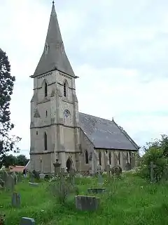
Staveley, North Yorkshire
Staveley is a village and civil parish in the Harrogate district of North Yorkshire, England. It is situated 4 miles (6.4 km) north of Knaresborough and near the A1(M) motorway. In the 2001 census, the village had a population of 444,[2] which had risen to 450 by the time of the 2011 census.[1] In 2015, North Yorkshire County Council estimated the population to have dropped to 440.[3]
| Staveley | |
|---|---|
 All Saints Church, Staveley | |
.svg.png.webp) Staveley Location within North Yorkshire | |
| Population | 450 (2011 census)[1] |
| OS grid reference | SE366627 |
| Civil parish |
|
| District | |
| Shire county | |
| Region | |
| Country | England |
| Sovereign state | United Kingdom |
| Post town | KNARESBOROUGH |
| Postcode district | HG5 |
| Police | North Yorkshire |
| Fire | North Yorkshire |
| Ambulance | Yorkshire |
History
The village is mentioned in the Domesday Book as belonging to Gospatric.[4] The name Staveley is Anglo-Saxon and means the clearing where the staves were brought from.[5]
The racehorse Staveley, winner of the 1805 St Leger Stakes, was born at nearby Boroughbridge.[6]
The village used to have a railway station on the now disused Pilmoor, Boroughbridge and Knaresborough Railway. When it opened, it was called Staveley, but from 1881 its name was taken from nearby Copgrove village to avoid confusion with Staveley in Derbyshire.[7]
The grade II listed, Church of All Saints, was built in 1864[8] and holds services twice-monthly.[9] The church replaces an earlier structure which is believed to have existed since Medieval times.[10]
Staveley was historically part of the West Riding of Yorkshire until 1974.[11]
Attractions
Staveley is home to many local attractions and has the following aspects:
- Staveley Community Primary School, rated 'good' in a 2015 Ofsted inspection.[12]
- The Royal Oak pub.[13]
- The railway line: abandoned for several years, it is now a significant feature of the landscape to the south east of the village.[14]
- Nature reserve: A long walk that stretches beyond Staveley. The reserve has many wild and rare species of flower and wildlife.[15]
References
- UK Census (2011). "Local Area Report – Staveley Parish (E04007421)". Nomis. Office for National Statistics. Retrieved 1 July 2019.
- UK Census (2001). "Local Area Report – Staveley Parish (36UD121)". Nomis. Office for National Statistics. Retrieved 1 July 2019.
- "2015 Population Estimates Parishes" (PDF). northyorks.gov.uk. December 2016. p. 13. Archived from the original (PDF) on 4 June 2022. Retrieved 1 July 2019.
- "Staveley | Domesday Book". opendomesday.org. Retrieved 1 July 2019.
- Staveley CACA 2011, p. 3.
- Sporting magazine (Oct. 1805-Mar. 1806). Wheble. 1806. p. 3. Retrieved 17 March 2013.
- Howat, Patrick (1991). The Pilmoor, Boroughbridge and Knaresborough Railway. Farsley: Martin Bairstow. p. 42. ISBN 978-1871944-05-1.
- Historic England. "Church of All Saints (Grade II) (1295924)". National Heritage List for England. Retrieved 1 July 2019.
- "Events - Staveley: All Saints - A Church Near You". www.achurchnearyou.com. Retrieved 1 July 2019.
- Staveley CACA 2011, p. 4.
- "History of Staveley, in Harrogate and West Riding | Map and description". www.visionofbritain.org.uk. Retrieved 24 November 2020.
- "Staveley Community Primary School URN: 121419". reports.ofsted.gov.uk. 28 December 2018. Retrieved 1 July 2019.
- Lemm, Elaine (25 August 2013). "Pub Of The Week: Royal Oak, Staveley". The Yorkshire Post. Retrieved 1 July 2019.
- Staveley CACA 2011, p. 5.
- "Staveley | YWT". www.ywt.org.uk. Retrieved 1 July 2019.
Sources
- Staveley Conservation Area Character Appraisal (PDF) (Report). Harrogate: Harrogate Borough Council. January 2011. Retrieved 1 July 2019.