Subtropical Cyclone Katie
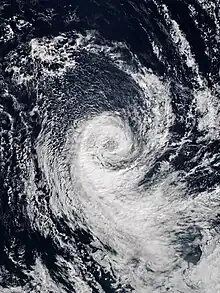
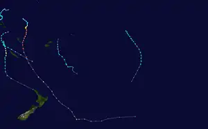
Subtropical Cyclone Katie, unofficially named by researchers, was an unusual weather event in early 2015. After the 2014–15 South Pacific cyclone season had officially ended, a rare subtropical cyclone was identified outside of the basin near Easter Island, during early May, and was unofficially dubbed Katie by researchers.[1] Katie was one of the few tropical or subtropical systems ever observed forming in the far Southeast Pacific, outside of the official basin boundary of 120°W, which marks the eastern edge of RSMC Nadi's and RSMC Wellington's warning areas, during the satellite era.[2] Due to the fact that this storm developed outside of the official areas of responsibility of the warning agencies in the South Pacific, the storm was not officially included as a part of the 2014–15 South Pacific cyclone season. However, the Chilean Navy Weather Service issued High Seas Warnings on the system as an extratropical low.[3]
 The storm near peak intensity, on 2 May | |
| Meteorological history | |
|---|---|
| Formed | 29 April 2015 |
| Remnant low | 4 May 2015 |
| Dissipated | 6 May 2015 |
| Subtropical cyclone | |
| 1-minute sustained | |
| Highest winds | 75 km/h (45 mph) |
| Lowest pressure | 993 hPa (mbar); 29.32 inHg |
| Overall effects | |
| Fatalities | None |
| Damage | None |
| Areas affected | Easter Island |
Part of the 2014–15 South Pacific cyclone season (unofficially) | |
Meteorological history

Tropical storm (39–73 mph, 63–118 km/h)
Category 1 (74–95 mph, 119–153 km/h)
Category 2 (96–110 mph, 154–177 km/h)
Category 3 (111–129 mph, 178–208 km/h)
Category 4 (130–156 mph, 209–251 km/h)
Category 5 (≥157 mph, ≥252 km/h)
Unknown
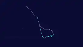
On 29 April 2015, near the end of the 2014–15 South Pacific cyclone season, an extratropical disturbance developed in the far Southeastern Pacific, before transitioning into a subtropical depression soon afterward.[4] The storm transitioned into a subtropical depression at 102.9°W, well to the east of the South Pacific basin's eastern boundary of 120°W.[4][2] Around this time, the Chilean Navy Weather Service began including the storm in their High Seas Warnings, continuing this until 4 May.[3] During the next couple of days, the system drifted to the southwest, before turning to the southeast. On 1 May, the storm intensified into a subtropical cyclone of tropical storm intensity, and looped westward.[4] During this time, the system encountered sea surface temperatures about 1 °C (1.8 °F) above average and low wind shear, due to an extremely strong El Niño event, allowing the storm to organize further.[1] On 2 May, the storm reached its peak intensity, with maximum sustained winds of 72 km/h (45 mph; 39 kn),[4][nb 1] and a minimum low pressure of 993 hPa (29.32 inHg).[3] Around this time, the storm was identified by researchers and unofficially named Katie.[1] During the next day, Katie slowly tracked westward while gradually weakening. On 4 May, Katie weakened into a subtropical depression and began accelerating to the northwest, passing to the east of Easter Island, before weakening further into a remnant low.[4] With this degeneration, the Chilean Navy Weather Service ceased issuing warnings on the storm.[3] On 6 May, Katie's remnant low dissipated.[3] During Katie's entire existence, the storm remained east of 120°W, outside of the South Pacific basin's official boundary.[4][3]
Records
Subtropical Cyclone Katie is unofficially the third-easternmost tropical or subtropical cyclone ever observed to form in the South Pacific Ocean, transitioning into a subtropical system near 102.9°W.[1][4] This broke the previous record of around 110°W, set by a tropical depression in May 1983.[5] "Katie" was also the first tropical or subtropical system to form east of the South Pacific basin's official eastern boundary of 120°W[2] since another tropical depression in May 1983.[5] However, in May 2018, Katie's record was broken by Subtropical Cyclone Lexi, which formed just a few hundred miles off the coast of Chile, near 80°W.[6][7] Tropical cyclogenesis is extremely rare in the far southeastern Pacific Ocean due to the cold sea-surface temperatures generated by the Humboldt Current, lack of tropical disturbance formation, and also due to unfavorable wind shear. As such, Cyclone Yaku in March 2023 is the only recorded instance of a tropical cyclone impacting western South America.[7][8][9][10] Tropical cyclone formation in this extreme part of the Southeast Pacific is so rare that no warning agencies have yet been assigned to the region east of 120°W.[1] Katie formed during an extremely strong El Niño event; the abnormally-warm waters 1 °C (1.8 °F) above average and low wind shear across the region may have contributed to the system's rare formation.[1] Although Katie's observed characteristics were consistent with that of a subtropical cyclone, detailed analysis revealed that the storm may have briefly transitioned into a tropical cyclone, around the time of its peak intensity.[3]
Notes
- All wind speeds in the article are maximum sustained winds sustained for one minute, unless otherwise noted.
See also
- Other storms of the same name
- Subtropical Cyclone Lexi
- Subtropical Cyclone Humberto
- 2006 Central Pacific cyclone
- Subtropical Storm 96C
- Hurricane Catarina
- Tropical Storm Rolf
- Cyclone Qendresa
- Cyclone Numa
- Cyclone Ianos
- 1996 Lake Huron cyclone
- Mediterranean tropical-like cyclone
- South Atlantic tropical cyclone
- 1982–83 South Pacific cyclone season – Saw a tropical depression developing east of 120°W
- 2017–18 South Pacific cyclone season
- Tropical cyclogenesis
- El Niño–Southern Oscillation
References
- Diamond, Howard J (25 August 2015). "Review of the 2014/15 Tropical Cyclone Season in the Southwest Pacific Ocean Basin". Climate Program Office. National Oceanic and Atmospheric Administration. Retrieved 16 October 2017.
- RA V Tropical Cyclone Committee (12 November 2012). Tropical Cyclone Operational Plan for the South-East Indian Ocean and the Southern Pacific Ocean 2012 (PDF) (Report No. TCP-24). World Meteorological Organization. pp. 15–20. Archived (PDF) from the original on 3 March 2016. Retrieved 29 March 2015.
- Blunden, J.; D. S. Arndt (October 2016). "State of the Climate in 2015". Bulletin of the American Meteorological Society. 97 (8): 149–150. Bibcode:2016BAMS...97.....B. doi:10.1175/2016BAMSStateoftheClimate.1. hdl:1874/353366.
- Steve Young (27 July 2015). "Monthly Global Tropical Cyclone Tracks April 2015". Australia Severe Weather. Retrieved 16 October 2017.
- Pacific ENSO Update — Quarter 1, 1998. Pacific ENSO Update (Report). Vol. 4. The Pacific ENSO Applications Climate Centre. Archived from the original on 4 March 2016.
- Levi Cowan (7 May 2018). "Subtropical Cyclone". Twitter. Retrieved 10 May 2018.
- John Leslie (9 May 2018). "Rare Subtropical Storm off the Coast of Chile". NOAA. Retrieved 10 May 2018.
- Jonathan Belles (9 May 2018). "Extremely Rare Southeast Pacific Subtropical Cyclone Forms Off the Chilean Coast". weather.com. The Weather Company. Retrieved 25 June 2019.
- Marshall Shepherd (10 May 2018). "Subtropical Cyclones Don't Normally Form Near Chile - But One Just Did". Forbes. Retrieved 22 February 2021.
- Rochabrun, Marcelo (14 March 2023). "Peru's Desert Coast Braces for More Deadly Rains From Cyclone". Bloomberg. Bloomberg News. Retrieved 20 April 2023.
