Sula, Montana
Sula is a census-designated place (CDP) in Ravalli County, Montana, United States.[2] It is named after the community of Sula, which it encompasses, and was established about 2010, prior to that year's census. The population of the CDP was 37 at the 2010 census.[3]
Sula, Montana | |
|---|---|
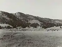 French basin near Sula, 1939 | |
 Sula | |
| Coordinates: 45°50′11″N 113°58′54″W | |
| Country | United States |
| State | Montana |
| County | Ravalli |
| Area | |
| • Total | 3.31 sq mi (8.57 km2) |
| • Land | 3.27 sq mi (8.47 km2) |
| • Water | 0.04 sq mi (0.09 km2) |
| Elevation | 4,422 ft (1,348 m) |
| Population (2020) | |
| • Total | 41 |
| • Density | 12.53/sq mi (4.84/km2) |
| Time zone | UTC-7 (Mountain (MST)) |
| • Summer (DST) | UTC-6 (MDT) |
| ZIP code | 59871 |
| Area code | 406 |
| FIPS code | 30-71800 |
| GNIS feature ID | 2583854[2] |
History
The area was originally called Ross's Hole from Alexander Ross, a Hudson’s Bay Company fur trader who had traveled through the area in spring 1824. In 1889, settlers named the post office after Ursula (Sula for short) Thompson, purportedly the first non-Indian child born in Ross’s Hole.[4]
Geography
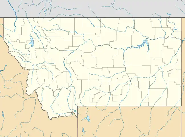
Sula is located at 45°50′12″N 113°58′54″W, along U.S. Route 93 in southern Ravalli County. It lies along the East Fork of the Bitterroot River at the west end of Ross' Hole, a wide valley surrounded by mountains. It is 35 miles (56 km) north along U.S. 93 to Hamilton, the county seat, and 58 miles (93 km) south over Lost Trail Pass to Salmon, Idaho.
According to the United States Census Bureau, the CDP has a total area of 3.3 square miles (8.6 km2), of which 3.3 square miles (8.5 km2) is land and 0.039 square miles (0.1 km2), or 1.09%, is water.[3]
Climate
This climatic region is typified by large seasonal temperature differences, with warm to hot (and often humid) summers and cold (sometimes severely cold) winters. According to the Köppen Climate Classification system, Sula has a humid continental climate, abbreviated "Dfb" on climate maps.[5]
| Climate data for Sula 14 NE, Montana 1991–2020 normals: 5155ft (1571m) | |||||||||||||
|---|---|---|---|---|---|---|---|---|---|---|---|---|---|
| Month | Jan | Feb | Mar | Apr | May | Jun | Jul | Aug | Sep | Oct | Nov | Dec | Year |
| Average high °F (°C) | 31.5 (−0.3) |
35.5 (1.9) |
43.1 (6.2) |
50.4 (10.2) |
61.3 (16.3) |
70.0 (21.1) |
81.3 (27.4) |
80.7 (27.1) |
69.7 (20.9) |
54.2 (12.3) |
37.8 (3.2) |
28.8 (−1.8) |
53.7 (12.0) |
| Daily mean °F (°C) | 20.8 (−6.2) |
23.7 (−4.6) |
31.3 (−0.4) |
37.7 (3.2) |
46.4 (8.0) |
53.3 (11.8) |
60.7 (15.9) |
59.5 (15.3) |
50.9 (10.5) |
40.1 (4.5) |
27.9 (−2.3) |
19.4 (−7.0) |
39.3 (4.1) |
| Average low °F (°C) | 10.1 (−12.2) |
11.9 (−11.2) |
19.5 (−6.9) |
25.0 (−3.9) |
31.6 (−0.2) |
36.7 (2.6) |
40.1 (4.5) |
38.4 (3.6) |
32.2 (0.1) |
26.0 (−3.3) |
17.9 (−7.8) |
9.9 (−12.3) |
24.9 (−3.9) |
| Average precipitation inches (mm) | 1.52 (39) |
1.38 (35) |
1.73 (44) |
1.72 (44) |
2.57 (65) |
2.87 (73) |
1.27 (32) |
1.08 (27) |
1.62 (41) |
1.48 (38) |
1.77 (45) |
1.81 (46) |
20.82 (529) |
| Average snowfall inches (cm) | 15.80 (40.1) |
17.00 (43.2) |
14.30 (36.3) |
6.30 (16.0) |
2.00 (5.1) |
0.90 (2.3) |
0.00 (0.00) |
0.00 (0.00) |
0.40 (1.0) |
2.40 (6.1) |
10.30 (26.2) |
19.00 (48.3) |
88.4 (224.6) |
| Source: NOAA[6] | |||||||||||||
References
- "ArcGIS REST Services Directory". United States Census Bureau. Retrieved September 5, 2022.
- U.S. Geological Survey Geographic Names Information System: Sula, Montana
- "Geographic Identifiers: 2010 Demographic Profile Data (DP-1): Sula CDP, Montana". U.S. Census Bureau, American Factfinder. Archived from the original on February 10, 2020. Retrieved March 22, 2013.
- "Sula". Montana Place Names Companion. Montana Historical Society. Retrieved April 9, 2021.
- Climate Summary for Sula, Montana
- "Sula 14 NE, Montana 1991-2020 Monthly Normals". Retrieved September 3, 2023.
- "Census of Population and Housing". Census.gov. Retrieved June 4, 2016.
Municipalities and communities of Ravalli County, Montana, United States | ||
|---|---|---|
| City |  Ravalli County map | |
| Towns | ||
| CDPs | ||
| Other communities | ||