Surandai
Surandai
Rajasooriyanallur,Suranthai | |
|---|---|
Town | |
 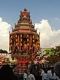  From top, left to right: Muppidathi Amman Temple, Baren Bruck School | |
 Surandai Location in Tamil Nadu, India | |
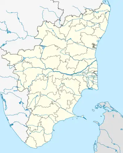
| Coordinates: 8.977272°N 77.420568°E | |
| Country | |
| State | Tamil Nadu |
| District | Tenkasi district |
| Government | |
| • Type | Municipality |
| • Body | Surandai Municipality[1] |
| Elevation | 132 m (433 ft) |
| Population (2011) | |
| • Total | 35,272[2] |
| Languages | |
| • Official | Tamil |
| Time zone | UTC+5:30 (IST) |
| PINCODE | 627859 |
| Telephone code | 04633 |
| Vehicle registration | TN76 |
History
Surandai Palayam was formed during the reign of Madurai Nayagam Khansagi. It was changed to Sameen during the British rule. Surandai city was formed by amalgamation of villages of Lower Surandai, Bangla Surandai and Surandai. This town, which used to be a village, was upgraded to a Town Panchayat in the 1980s. Surandai was upgraded to a municipality on 24 August 2021 after the creation of Tenkasi district in India.
Earlier “Surandai” was known as “Raja Sooriya Nallur” then it becomes “Suranthai”. For the past 50 years, the city name is Surandai.
Polygar rule and the revolts
As the Dalavay Mudali, the governor of Tirunelveli, became increasingly independent of Madurai during the time of troubles that began in 1732, some of the Marava polygars of the province openly defied the Dalavay's authority and stopped paying tribute. Polygar Kattari Velladurai was the leader of the defiant polygars from Vadagarai, Nerkattumseval ruled by Puli Thevar and Sivagiri. Surandai was one of the palayams that joined Puli Thevar’s coalition in 1754–1762 but abandoned the cause before the polygars’ final defeat in 1762. When Kollamkondan again rebelled in 1764, following the execution of Yusuf Khan for having betrayed the nawab, Surandai was quick to join. Victories over the Anglo-Nawabi forces helped the revolt spread to other polygars. At the end of the First Polygar War in 1799, the polygar of Surandai surrendered one fort and 61 armed men to Major J. Bannerman.
Zamindari
The Palaiyam survived into the 19th century as a zamindari; at the time of the permanent settlement of 1802, Polygar Sulava Tevar held seven villages. In 1879, the zamindari had an area of 1.34 sq. miles, and a population of 2,580; it was bought by Uthumalai and annexed to that estate in 1874.[3]
Geography
Surandai is located at 8.977272°N 77.420568°E.[4] It has an average elevation of 132 metres (433 feet). It is situated 20 km from Coutrallam Falls, 12 km away from Tenkasi and 50 km from Tirunelveli, District Head. It is 30 km away from Sankarankovil. The nearest railway station is Tenkasi and the nearest airport is Tuticorin(Thoothukudi), 86 km from Surandai. Surandai panchayat town comprised Surandai and Keelasurandai, Anai kulam, Kurungavanam, Kulayaneri, Kadayalurutti, Aladipatti, Kurichanpatti, Vadiur, Karayalanoor, Mariathaipuram, Paranguntrapuram, Kalingapatti, Achankundram, Bangalow Surandai and part of Ammayapuram. Surandai, which was once a village with primarily agricultural and palm tree cultivation with allied activities, presently has grown into a bustling centre for complete trade and business for nearby Panchayats.
Demographics
As of 2011India census,[5] Surandai Panchayat had a population of 35272. Males constitute 50% of the population and females 50%. Surandai has an average literacy rate of 65%, higher than the national average of 59.5%: male literacy is 73%, and female literacy is 57%. In Surandai, 12% of the population is under 6 years of age.
Municipal administration and politics
Surandai municipality established in 2021 [6] initially it was a Town panchayat and upgraded as municipality
Places of Worship
- St. Pauls's Church Keela Surandai
- Zion Church
- St. Antony's Church
- C.S.I Christ Church
- Srinivasa Perumal Kovil
- Alagu Parvathi Amman Kovil
- Sri Pathirakali Amman Kovil
- sri Hanuman & Theradi Madasamy Kovil
- Sri Vetri Pathirakali Amman Kovil
- Kulathur Ayyanar Kovil
- Sri Pottal Madasamy Kovil
- Sivagami Amman Sametha Veerapandeeswarar Temple
- Sivagami Amman Sametha SivaGurunathar Temple,
- Muppidathi Amman Temple, Sivagurunatha Puram,
- Sri Muppidathi Amman Temple, Varagunaramapuram.
- Sri Sudalai Madasamy Kovil
- Sri Mathalapandi Temple
- Arulmigu Kanniamman Kovil
- Thirumalai Aandavar Temple in Sivagurunatha Puram
- Alagu Parvathy Amman Temple
- Arulmigu Sri Vadakuththi Amman Temple, Thiravia Nagar
- Arulmigu Sri Thirattu Swamy Temple, Thiravia Nagar
- Arulmigu Sri Veyilkantha Amman Temple
- Arulmigu Sri Vetri Vinayagar Temple, Thiravia Nagar
- Arulmigu Sri Sorna
Schools and colleges
- Kamarajar Government Arts College, Surandai
- Government Higher Secondary School
- Baren Bruck Higher Secondary School
- Panchayad Union Primary School
- Shri Jayandra Matriculation Higher Secondary School
- Muslim Primary School
- Jawaharlal Middle School
- Jemimah Nursery and Primary School
- Sri Parasakthi Matriculation School (or)
- Sermathai Vasan Higher Secondary School
- Rajendra Wisdom School
- TDTA Middle School
- RC Middle School
- Perunthalaivar Kamarajar Government Girls Higher Secondary
- A.G Matriculation School
- TDTA Primary School in Bungalow Surandai
- S R Matriculation School
Hospitals
- Government Hospital,
- Ponra Nursing Home,
- Maris Hospital,
- Kamala Hospital,
- Jeyam Haspital,
- Thangamathi Hospital,
- Mahalakshmi Nursing Home,
- Gothai Hospital,
- mathura Hospital,
- Jeeva Teeth Hospital,
- ABI Dental Clinic,
- Aravind Eye Hospital, Etc...
References
- "மேலும் 6 மாநகராட்சிகள்!:அமைச்சர் நேரு அறிவிப்பு". 25 August 2021.
- https://censusindia.gov.in/census.website/data/data-visualizations/PopulationSearch_PCA_Indicators
- http://princelystatesofindia.com/Polegars/surandai.html
- Falling Rain Genomics, Inc - Surandai
- "Census of India 2001: Data from the 2001 Census, including cities, villages and towns (Provisional)". Census Commission of India. Archived from the original on 16 June 2004. Retrieved 1 November 2008.
- "Ahead of polls to urban local bodies, TN to have six more corporations, 28 new municipalities- The New Indian Express".